METAR & TAF W95
W95 does not publish a METAR.
Showing the nearest reporting station: KHSE (BILLY MITCHELL) · 18.8 NM away. Conditions at W95 may differ.
METAR · KHSE
Observed 14:51Z
KHSE 271451Z AUTO 12008KT 10SM CLR 27/19 A2989 RMK AO2 SLP122 T02720194 53007 $
- Wind
- 120° @ 8 kt
- Visibility
- 10 SM
- Temp / Dew
- 27°C / 19°C
- Altimeter
- 29.89 inHg
- Clouds
- CLR
- Density alt
- 1,482 ft
- Ceiling
- Unlimited
- Rules
- VFR
Airport info & contacts
Manager on record, flight service, ARTCC, attendance schedule and pattern altitude — published by the FAA and refreshed every 28 days.
Location
- From city
- 1 NM E
- VFR sectional
- CHARLOTTE
- ARTCC
- ZDC · WASHINGTON
- NOTAM facility
- RDU (NOTAM-D)
Airport manager
- Name
- MARK SEAMAN
- Phone
- 252-475-9000
- Address
- 1401 NATIONAL PARK DRIVE, MANTEO NC 27954
Flight service · Hours
- FSS RDU
- RALEIGH1-800-WX-BRIEF
- Attendance
- Unattended
Frequencies
Tap any row to copy the frequency to your clipboard.
Runways & pattern
Full pagePattern entry · RWY 06
LEFT TRAFFICRunway end performance
| End | TORA | TODA | ASDA | LDA | VGSI | Approach lights | Obstruction |
|---|---|---|---|---|---|---|---|
| 06 | — | — | — | — | — | — | 5', brush, 226' from thr, 107' R of cntrln, slope 5 |
| 24 | — | — | — | — | — | — | 9', brush, 226' from thr, 45' R of cntrln, slope 2 |
Declared distances in feet. TORA = takeoff run available, TODA = takeoff distance, ASDA = accelerate-stop, LDA = landing distance.
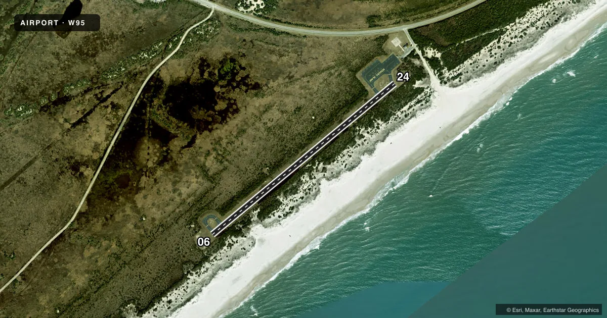
Airport sketch
Runways drawn to scale from FAA survey coordinates, rendered over satellite imagery. Not for navigation.
Approaches & charts
Services on the field
Fuel grades, oxygen, maintenance, ramp storage and lighting — as declared to the FAA by the airport operator.
Fuel & services
- Fuel
- Not available
- Oxygen (bottled)
- Not available
- Oxygen (bulk)
- Not available
- Airframe repair
- Not available
- Power plant repair
- Not available
Ramp & ground
- Transient storage
- Tie-down
- Landing fee
- No fee published
- Customs
- Not available
- Lighting schedule
- SEE RMK
- Beacon schedule
- SEE RMK
- Beacon
- White / Green / Yellow (heliport)(WGY)
- Wind indicator
- Yes
- Segmented circle
- No
Fuel & FBOs
Cheapest 100LL and Jet A on the field and nearby. Always confirm with the FBO before taxi.
Airport notes
Surface conditions, obstructions, local procedures, lighting outages and other notes published with each FAA cycle.
General notes
- ARPT CLSD 30 MIN AFTER SS TIL 30 MIN BEFORE SR.
- HIGH SPEED LOW LEVEL MIL OPS INVOF OF ARPT.
- FLOCKS OF SEAGULLS ON AND NEAR RWY ARND STANDING WATER AFTER HVY RAINS.
- RWY SAFETY AREA IS LOOSE SAND; NOT SUITABLE FOR ACFT.
- RWY NOT LGTD - NIGHT OPS PROHIBITED.
- ARPT IS WI CAPE HATTERAS NTL SEASHORE. MNTN 2000 FT VER & HORIZONTAL DIST FROM SEASHORE BEACHES.
- RWY SUBJ RESIDUAL FLOODING DURG AND AFT HEAVY RAIN.
- KEY CODE ACES TO PILOT LOUNGE.
- HELIPAD FOR EMERG OPS ONLY.
- FOR CD CTC WASHINGTON ARTCC AT 703-771-3587.
- 30 FT PLINE ALONG NC HWY 12 N OF HELIPAD.
Lighting notes
- ACTVT HELI BEACON - CTAF.
- ACTVT HELI PERIMETER LTS ONLY - CTAF.
Runway surface & condition
- H1BEST APCH FM NE OR SW.
Approach & departure obstructions
- 065 FT BRUSH 0-200 FT FM THR 81 FT R OF CNTRLN; 5 FT BRUSH 50-200 FT FM THR 145 FT L OF CNTRLN.
- 2412 FT SCRUB TREES 155 FT FM THR 94 FT R OF CNTRLN; 10 FT SCRUB TREES 0-200 FT FM THR 74 FT L OF CNTRLN.
- H1APCH SLOPE FOR NE HELI APCH IS 13:1 DUE TO 12 FT BRUSH 162 FT FM HELI OFFSET 31 FT L; AND APCH SLOPE FOR SW HELI APCH IS 10:1 DUE TO 15 FT TREES 151 FT FROM HELI OFFSET 0 FT BOTH SIDES.
Other notes
- WINDSOCK FOR HELI LGTD.
- OWNERNCDOT DIVISION OF AVIATION COOPERATING AGENCY UNDER MOU; CTC NR 919-814-0550.
- MANAGERNATL PARKS SVC NR ANSWERED 7 DAYS A WEEK BTWN 0800 TO 1700.
VFR map & nearby airports
VFR sectional. Tap any ICAO chip to open that airport.
Key facts · W95
Answer card- ICAO
- W95
- Name
- OCRACOKE ISLAND
- Location
- OCRACOKE, NORTH CAROLINA
- Elevation
- 4 ft MSL
- Traffic pattern altitude
- 1,004 ft MSL (1,000 AGL)
- Control tower
- Non-towered (use CTAF)
- Total runways
- 1
- Longest runway
- 06/24 · 2,998 ft
- Published ILS approaches
- 0
- Published frequencies
- 3
- Magnetic variation
- 9°
- Current flight rules
- VFR
- Current wind
- 120° at 8 kt
- Favored runway now
- RWY 06
Ocracoke Island Airport sits in Ocracoke, North Carolina. Field elevation is 4 ft MSL. It has one runway, 06/24, which is 2,998 ft long and asphalt. There is no control tower. CTAF is 122.9. Approach and departure service is handled by Cherry Point on 119.75 and 360.775.
No ILS approaches are published here. Pattern altitude is not published, so use the standard 1,000 ft AGL for light piston operations unless the current FAA Chart Supplement says otherwise. The airport is closed 30 minutes after sunset until 30 minutes before sunrise. Night operations are prohibited because the runway is not lighted.
This field has a few things a first-time pilot should plan for. The runway is subject to residual flooding during and after heavy rain. The runway safety area is loose sand, so do not count on it for a normal overrun. There are brush and tree obstructions near both runway ends. The published approach note says the best approach is from the northeast or southwest. There are no on-field FBOs listed. Key code access is available to the pilot lounge. Check the current FAA Chart Supplement for any updated local restrictions before you go.