METAR & TAF KFFA
Current METAR
Observed 10:35Z
KFFA 271035Z AUTO 16003KT 10SM SCT065 21/19 A2986 RMK AO2 T02070185
- Wind
- 160° @ 3 kt
- Visibility
- 10 SM
- Temp / Dew
- 21°C / 19°C
- Altimeter
- 29.86 inHg
- Clouds
- SCT
- Density alt
- 809 ft
- Ceiling
- Unlimited
- Rules
- VFR
Airport info & contacts
Manager on record, flight service, ARTCC, attendance schedule and pattern altitude — published by the FAA and refreshed every 28 days.
Location
- From city
- 1 NM W
- VFR sectional
- WASHINGTON
- ARTCC
- ZDC · WASHINGTON
- NOTAM facility
- FFA (NOTAM-D)
Airport manager
- Name
- MARK SEAMAN
- Phone
- 252-475-9000
- Address
- 1401 NATIONAL PARK DR., MANTEO NC 27984-2708
Flight service · Hours
- FSS RDU
- RALEIGH1-800-WX-BRIEF
- Attendance
- Unattended
Frequencies
Tap any row to copy the frequency to your clipboard.
Runways & pattern
Full pagePattern entry · RWY 21
RIGHT TRAFFICRunway end performance
| End | TORA | TODA | ASDA | LDA | VGSI | Approach lights | Obstruction |
|---|---|---|---|---|---|---|---|
| 03 | — | — | — | — | — | — | 59', trees, 296' from thr, 150' R of cntrln, slope 1 |
| 21 | — | — | — | — | — | — | 37', trees, 362' from thr, 214' R of cntrln, slope 4 |
Declared distances in feet. TORA = takeoff run available, TODA = takeoff distance, ASDA = accelerate-stop, LDA = landing distance.
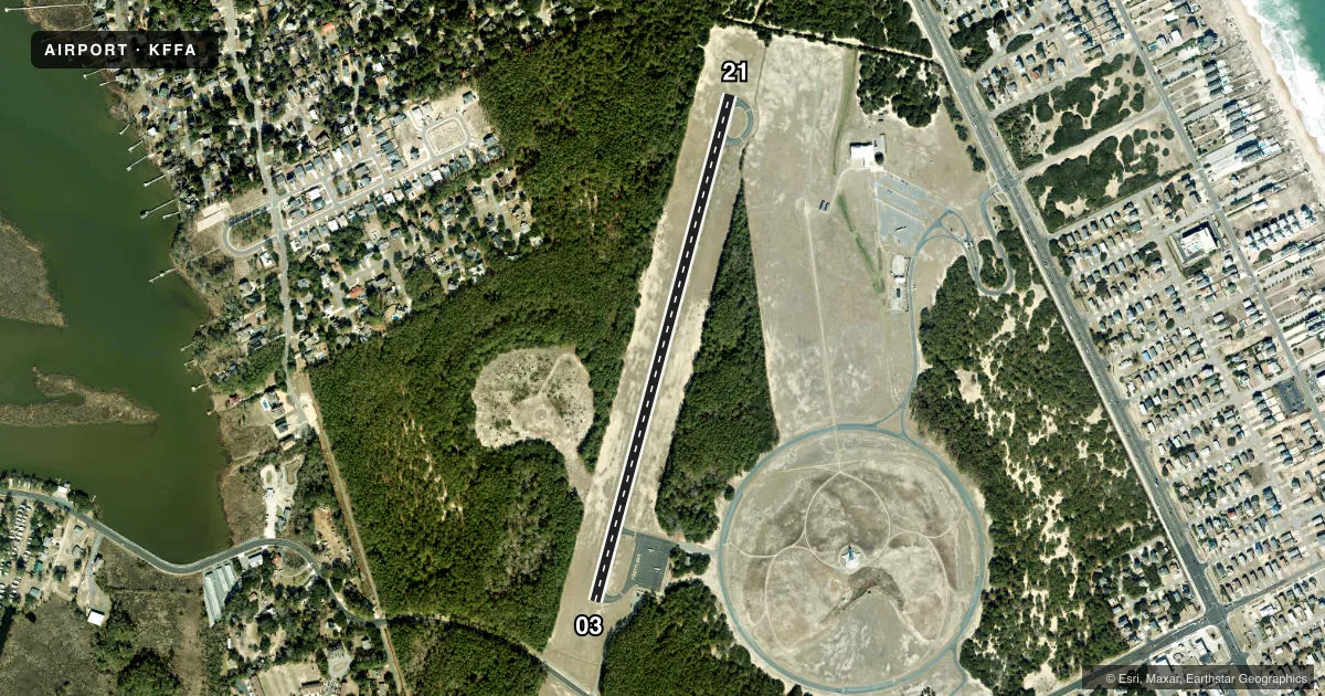
Airport sketch
Runways drawn to scale from FAA survey coordinates, rendered over satellite imagery. Not for navigation.
Approaches & charts
Services on the field
Fuel grades, oxygen, maintenance, ramp storage and lighting — as declared to the FAA by the airport operator.
Fuel & services
- Fuel
- Not available
- Oxygen (bottled)
- Not available
- Oxygen (bulk)
- Not available
- Airframe repair
- Not available
- Power plant repair
- Not available
Ramp & ground
- Transient storage
- Tie-down
- Landing fee
- No fee published
- Customs
- Not available
- Wind indicator
- Lighted
- Segmented circle
- Yes
Fuel & FBOs
Cheapest 100LL and Jet A on the field and nearby. Always confirm with the FBO before taxi.
Airport notes
Surface conditions, obstructions, local procedures, lighting outages and other notes published with each FAA cycle.
General notes
- MAX OF 24 HRS PRKG PMTD. NO MORE THAN TWO OVNGT STAYS PER MONTH.
- SITE OF FIRST FLIGHT BY WRIGHT BROTHERS.
- RESTROOM FAC ON SITE; KEY CODE ACES TO PILOT LOUNGE.
- HANG GLIDING & POWERED HANG GLIDING TO 4000 FT INVOF ARPT FROM SR-SS YEAR ROUND.
- ARPT CLSD 30 MIN AFT SS TIL 30 MIN BEFORE SR.
- 100 FT+ MKD TRANSMISSION PLINES W/HAZARD BALLS, LIGHTS 1300 FT FM THR IN APCH AREA RWY 21; 300 FT TWR AND TANK 1/2 MI N OF RWY 21 THR.
- HOLDLINES RWY 21 ARE 115 FT FM CNTRLN.
- RWY 21 HAS 10 FT DEEP DITCH 400 FT FM THR.
- DEER AND BIRDS ON & INVOF ARPT.
- FOR CD CTC WASHINGTON ARTCC AT 703-771-3587.
Approach & departure obstructions
- 0310 FT ROAD 125 FT R; 0-200 FT FM THR AND 35 FT TREES 82 FT FM THR OFFSET 206 FT L.
- 2137 FT TREES 109 FT FM THR OFFSET 213 FT R.
Other notes
- VFR OPS ONLY.
- OWNERNCDOT DIVISION OF AVIATION COOPERATING AGENCY UNDER MOU; CTC NR 919-814-0550.
- MANAGERNTL PARKS SVC NR ANSWERED 7 DAYS A WEEK BTWN 0800 TO 1700.
VFR map & nearby airports
VFR sectional. Tap any ICAO chip to open that airport.
Key facts · KFFA
Answer card- ICAO
- KFFA
- Name
- FIRST FLIGHT
- Location
- KILL DEVIL HILLS, NORTH CAROLINA
- Elevation
- 11.9 ft MSL
- Traffic pattern altitude
- 1,011.9 ft MSL (1,000 AGL)
- Control tower
- Non-towered (use CTAF)
- Total runways
- 1
- Longest runway
- 03/21 · 3,000 ft
- Published ILS approaches
- 0
- Published frequencies
- 3
- Magnetic variation
- 11°
- Current flight rules
- VFR
- Current wind
- 160° at 3 kt
- Favored runway now
- RWY 21
First Flight is in Kill Devil Hills, North Carolina. Field elevation is 11.9 ft MSL. The airport has one runway, 03/21, which is 3,000 ft of asphalt. There is no control tower. No ILS approaches are published. Pattern altitude is not published, so use the standard 1,000 ft AGL for light piston operations unless the current Chart Supplement says otherwise.
This field is VFR only. The airport is closed 30 minutes after sunset until 30 minutes before sunrise. Hang gliding and powered hang gliding operate in the vicinity up to 4,000 ft from sunrise to sunset year round. That matters for traffic planning near the field. Runway 21 also has published obstacles near the approach end, including trees, a road, a ditch and marked power lines farther out. There is also a tower and tank north of the threshold. Runway 21 hold lines sit 115 ft from centerline.
There are no on-field FBOs listed, so plan ahead and verify services with the airport operator or the FBO directly by phone before arrival. The airport has a 24-hour parking limit. No more than two overnight stays per month are allowed. For clearance delivery, contact Washington ARTCC at 703-771-3587. This is the site of the Wright Brothers' first flight, so expect a small field with special-use activity nearby and stay sharp on the published remarks.