METAR & TAF KCPK
Current METAR
Observed 13:35Z
KCPK 271335Z AUTO 00000KT 10SM SCT010 OVC085 24/21 A2987 RMK AO2 T02390207
- Wind
- 000° @ 0 kt
- Visibility
- 10 SM
- Temp / Dew
- 24°C / 21°C
- Altimeter
- 29.87 inHg
- Clouds
- OVC
- Density alt
- 1,165 ft
- Ceiling
- 8,500 ft AGL
- Rules
- VFR
Airport info & contacts
Manager on record, flight service, ARTCC, attendance schedule and pattern altitude — published by the FAA and refreshed every 28 days.
Location
- From city
- 12 NM S
- VFR sectional
- WASHINGTON
- ARTCC
- ZDC · WASHINGTON
- NOTAM facility
- CPK (NOTAM-D)
Airport manager
- Name
- CHRIS SCHRANTZ
- Phone
- 757-432-8110
- Address
- 2800 AIRPORT DRIVE, CHESAPEAKE VA 23323-6402
Flight service · Hours
- FSS DCA
- LEESBURG1-800-WX-BRIEF
- Attendance
- 0800-2000
Frequencies
Tap any row to copy the frequency to your clipboard.
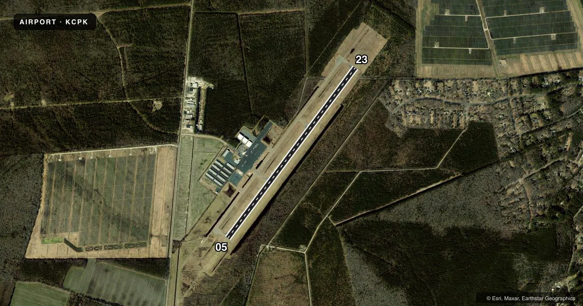
Runways & pattern
Full pagePattern entry · RWY 05
LEFT TRAFFICRunway end performance
| End | TORA | TODA | ASDA | LDA | VGSI | Approach lights | Obstruction |
|---|---|---|---|---|---|---|---|
| 05 | — | — | — | — | PAPI 4-box left(3°) | MALSR | 27', tree, 490' from thr, 285' R of cntrln, slope 10 |
| 23 | — | — | — | — | PAPI 4-box left(3°) | — | 28', tree, 443' from thr, 247' R of cntrln, slope 8 |
Declared distances in feet. TORA = takeoff run available, TODA = takeoff distance, ASDA = accelerate-stop, LDA = landing distance.
Airport sketch
Runways drawn to scale from FAA survey coordinates, rendered over satellite imagery. Not for navigation.
Approaches & charts
ILS · 1
Services on the field
Fuel grades, oxygen, maintenance, ramp storage and lighting — as declared to the FAA by the airport operator.
Fuel & services
- Fuel
- 100LLA
- Airframe repair
- Major
- Power plant repair
- Major
- Other services
- AVNCS,CHTR,INSTR,RNTL,SALES
Ramp & ground
- Transient storage
- Tie-down
- Hangar
- Landing fee
- No fee published
- Lighting schedule
- SEE RMK
- Beacon schedule
- SS-SR
- Beacon
- White / Green (civil land)(WG)
- Wind indicator
- Lighted
- Segmented circle
- Yes
Fuel & FBOs
Cheapest 100LL and Jet A on the field and nearby. Always confirm with the FBO before taxi.
Airport notes
Surface conditions, obstructions, local procedures, lighting outages and other notes published with each FAA cycle.
General notes
- DEER AND GEESE ON & INVOF RY.
- GCO AVBL ON FREQ 135.075 THRU NORFOLK CD. IF UN, FOR CD CTC NORFOLK APCH AT 757-464-0757.
- NOISE ABATEMENT PROCEDURES IN EFFECT; CTC AMGR 757-432-8110.
Lighting notes
- ACTVT HIRL RY 05/23, MALSR RY 05 AND REIL RY 23 - CTAF.
Fuel notes
- 100LLFOR FUEL AFTER HRS CALL 757-421-9000.
- AFOR FUEL AFT HRS CALL IN ADVANCE 757-421-9000. SELF-SVC AVBL.
Approach & departure obstructions
- 0518 FT TREE 276 FT R OF CNTRLN.
Other notes
- THIS AIRPORT HAS BEEN SURVEYED BY THE NATIONAL GEODETIC SURVEY.
- SPB ASP: PRVDD SAME TFC PAT IS USED FOR RWY & SEALANE; ARPT MGR ESTABS MIN CROSSWIND LNDG CRITERIA & HAS THIS INFO PUBLD LOCAL & IN AIM.
- TPA 1000FT AGL (1020 FT MSL) TURBINE/LARGE ACFT 1500 FT AGL (1520 FT MSL).
VFR map & nearby airports
VFR sectional. Tap any ICAO chip to open that airport.
Key facts · KCPK
Answer card- ICAO
- KCPK
- Name
- CHESAPEAKE RGNL
- Location
- NORFOLK, VIRGINIA
- Elevation
- 18.7 ft MSL
- Traffic pattern altitude
- 1,018.7 ft MSL (1,000 AGL)
- Control tower
- Non-towered (use CTAF)
- Total runways
- 1
- Longest runway
- 05/23 · 5,500 ft
- Published ILS approaches
- 1
- Published frequencies
- 5
- Magnetic variation
- 11°
- Current flight rules
- VFR
- Current wind
- 000° at 0 kt
- Favored runway now
- –
Chesapeake Regional Airport (KCPK) sits in Norfolk, Virginia. Field elevation is 18.7 ft MSL. The airport has one runway, 05/23, which is 5,500 ft long. There is no control tower. Traffic pattern altitude is 1,020 ft MSL. That is 1,000 ft AGL for light piston traffic. Turbine and large aircraft use 1,520 ft MSL. That is 1,500 ft AGL.
Runway 05 has an ILS. The field also has a special purpose beacon approach. High intensity runway lighting is available on 05/23. The approach lighting system with runway alignment indicator lights is on 05. Runway end identifier lights are on 23. Deer and geese are reported on and near the runway. Keep a sharp scan on arrival and departure. There is also an 18 ft tree 276 ft right of the centerline on runway 05.
Horizon Aviation Services is on the field. It carries 100LL, Jet A and Jet A Prist. Self-serve fuel is available. For after-hours fuel, call ahead at 757-421-9000. Noise abatement procedures are in effect. Contact the airport manager for the current local guidance before you go. For clearances, Norfolk Approach can help through the ground communications outlet on 135.075 when needed.