METAR & TAF KMRH
Current METAR
Observed 18:58Z
KMRH 271858Z AUTO 16007KT 130V200 10SM CLR 29/21 A2984 RMK AO2 SLP103 T02890211
- Wind
- 160° @ 7 kt
- Visibility
- 10 SM
- Temp / Dew
- 29°C / 21°C
- Altimeter
- 29.84 inHg
- Clouds
- CLR
- Density alt
- 1,792 ft
- Ceiling
- Unlimited
- Rules
- VFR
Airport info & contacts
Manager on record, flight service, ARTCC, attendance schedule and pattern altitude — published by the FAA and refreshed every 28 days.
Location
- From city
- 1 NM N
- VFR sectional
- CHARLOTTE
- ARTCC
- ZDC · WASHINGTON
- NOTAM facility
- MRH (NOTAM-D)
Airport manager
- Name
- JANIE MASON
- Phone
- 252-728-1928
- Address
- 180 AIRPORT ROAD, BEAUFORT NC 28516
Flight service · Hours
- FSS RDU
- RALEIGH1-800-WX-BRIEF
- Attendance
- 0800-DUSK
Frequencies
Tap any row to copy the frequency to your clipboard.
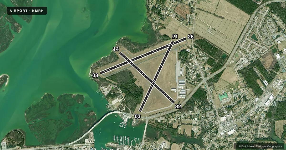
Runways & pattern
Full pagePattern entry · RWY 14
LEFT TRAFFIC| Runway | Heading (°M) | Length | Surface | Traffic |
|---|---|---|---|---|
| 08/26 | 60° / 240° | 5,004 ft | ASPH | 26 R |
| 03/21 | 17° / 197° | 4,192 ft | ASPH | 21 R |
| 14/32Favored | 125° / 305° | 4,001 ft | ASPH | Standard L |
Runway end performance
| End | TORA | TODA | ASDA | LDA | VGSI | Approach lights | Obstruction |
|---|---|---|---|---|---|---|---|
| 08 | — | — | — | — | PAPI 2-box left(3°) | — | 35', boat, 1000' from thr, 0' R of cntrln, slope 22 |
| 26 | — | — | — | — | PAPI 2-box right(3°) | — | 20', road, 325' from thr, 0' R of cntrln, slope 6 |
| 03 | — | — | — | — | PAPI 2-box left(4°) | — | 20', road, 312' from thr, 0' R of cntrln, slope 5 |
| 21 | — | — | — | — | PAPI 2-box left(4°) | — | 43', trees, 1125' from thr, 170' R of cntrln, slope 21 |
Declared distances in feet. TORA = takeoff run available, TODA = takeoff distance, ASDA = accelerate-stop, LDA = landing distance.
Airport sketch
Runways drawn to scale from FAA survey coordinates, rendered over satellite imagery. Not for navigation.
Approaches & charts
Services on the field
Fuel grades, oxygen, maintenance, ramp storage and lighting — as declared to the FAA by the airport operator.
Fuel & services
- Fuel
- 100LLA1+
- Oxygen (bottled)
- HIGH/LOW
- Oxygen (bulk)
- Not available
- Airframe repair
- Major
- Power plant repair
- Major
- Other services
- CHTR,INSTR,PAJA,RNTL,SURV
Ramp & ground
- Transient storage
- Tie-down
- Hangar
- Landing fee
- No fee published
- Customs
- Not available
- Lighting schedule
- SEE RMK
- Beacon schedule
- SS-SR
- Beacon
- White / Green (civil land)(WG)
- Wind indicator
- Lighted
- Segmented circle
- Yes
Fuel & FBOs
Cheapest 100LL and Jet A on the field and nearby. Always confirm with the FBO before taxi.
Airport notes
Surface conditions, obstructions, local procedures, lighting outages and other notes published with each FAA cycle.
General notes
- NO LINE OF SIGHT BTWN RWY ENDS.
- DEER AND BIRDS ON & INVOF ARPT AND BIRD-DROPPED SHELLS MAY CAUSE FOD.
- NOISE ABATEMENT PROCEDURES IN EFFECT, CTC AMGR 252-728-1928.
- AVOID OVERFLIGHTS OF BEAUFORT WATERFRONT AND BEAUFORT NATIONAL REGISTER HISTORIC DISTRICT.
- FOR CD CTC CHERRY POINT APCH AT 252-466-5960.
- MIL ACFT RWY 08/26 REQUIRED FOR NOISE ABATEMENT.
- SKYDIVING OPERATIONS - DO NOT OVERFLY ARPT.
- DUE TO VOLUME OF MIL TFC AND TRNG RCMD ALL ACFT USING MRH CTC CHERRY POINT APP 132.57 AB AND 125.65 PRIOR TO MRH DEP.
Lighting notes
- ACTVT REIL RWY 08 & 26; PAPI RWY 03 & 21; MIRL RWY 03/21 & RWY 08/26 - CTAF. PAPI RWY 08 & 26 OPER CONSLY.
Runway surface & condition
- 14/32RWY 14/32 CLSD.
Approach & departure obstructions
- 039 FT FENCE 191 FT FM END OF RWY BOTH SIDES OF CNTRLN.
- 087 FT BRUSH 100-200 FT FM THR OFFSET 109 FT R OF CNTRLN.
- 1410 FT BRUSH 0-200 FT FM THR OFFSET 171 FT R OF CNTRLN, AND 11 FT TREES 43 FT FM THR OFFSET 206 FT R OF CNTRLN.
- 2113 FT TREES 63 FT FM END OF RWY OFFSET 165 FT R OF CNTRLN.
- 03APCH RATIO 42:1 AT DSPLCD THR DUE TO 27 FT MAST 1366 FT FM DSPLCD THLD OFFSET 367 FT L OF CNTRLN.
- 08APCH RATIO 20:1 AT DSPLCD THR DUE TO 21 FT ROAD 627 FT FM DSPLCD THR BOTH SIDES OF CNTRLN.
- 21APCH RATIO 33:1 AT DSPLCD THR DUE TO 42 FT TREES 1622 FT FM DSPLCD THR OFFSET 142 FT L OF CNTRLN.
- 32APCH RATIO 13:1 AT DSPLCD THR DUE TO 61 FT TREES 995 FT FM DSPLCD THR OFFSET 85 FT R OF CNTRLN.
- 0845 FT MAST HGT.
- 1445 FT MAST HGT.
Other notes
- TPA: SINGLE ENGINE 1000 FT AGL, TWIN ENGINE 1500 FT AGL.
- CHECK IF HANGAR SPACE IS AVAIL W/ ARPT MAN.
- 1FOR SERVICE AFTER HOURS CALL 843-465-2846.
VFR map & nearby airports
VFR sectional. Tap any ICAO chip to open that airport.
Key facts · KMRH
Answer card- ICAO
- KMRH
- Name
- MICHAEL J SMITH FLD
- Location
- BEAUFORT, NORTH CAROLINA
- Elevation
- 10.1 ft MSL
- Traffic pattern altitude
- 1,010.1 ft MSL (1,000 AGL)
- Control tower
- Non-towered (use CTAF)
- Total runways
- 3
- Longest runway
- 08/26 · 5,004 ft
- Published ILS approaches
- 0
- Published frequencies
- 5
- Magnetic variation
- 8°
- Current flight rules
- VFR
- Current wind
- 160° at 7 kt
- Favored runway now
- RWY 14
Michael J Smith Fld sits in Beaufort, North Carolina. The field elevation is 10.1 ft MSL. It has 3 asphalt runways. The longest is runway 08/26 at 5,004 ft. There is no control tower. Pattern altitude is published at 1,000 ft AGL for single-engine aircraft and 1,500 ft AGL for twin-engine aircraft.
No ILS approaches are published here. Cherry Point handles approach and departure work on 132.575 and 299.6 MHz. CTAF and UNICOM are both 122.8. Crystal Coast Aviation is on the field. It carries 100LL and Jet A. Call (252) 728-2323 for current services.
This is a low-elevation coastal airport, so density altitude is usually not the main issue. The bigger concerns are local traffic flow, noise abatement and staying clear of the waterfront and the Beaufort National Register Historic District. Military aircraft use runway 08/26 as required for noise abatement. The Chart Supplement also notes deer, birds and bird-dropped shells on or near the airport. There is no line of sight between runway ends. Runway 08 and 26 have runway end identifier lights. Runway 03/21 and 08/26 have medium intensity runway lights controlled by CTAF. Precision approach path indicators are on 03/21. Check runway 14 for the published brush and tree obstructions near the threshold before you plan a landing there.