METAR & TAF KOAJ
Current METAR
Observed 15:56Z
KOAJ 271556Z 20004KT 10SM FEW027 SCT046 BKN090 29/23 A2988 RMK AO2 SLP119 T02890233 $
- Wind
- 200° @ 4 kt
- Visibility
- 10 SM
- Temp / Dew
- 29°C / 23°C
- Altimeter
- 29.88 inHg
- Clouds
- BKN
- Density alt
- 1,845 ft
- Ceiling
- 9,000 ft AGL
- Rules
- VFR
Airport info & contacts
Manager on record, flight service, ARTCC, attendance schedule and pattern altitude — published by the FAA and refreshed every 28 days.
Location
- From city
- 10 NM NW
- VFR sectional
- CHARLOTTE
- ARTCC
- ZDC · WASHINGTON
- NOTAM facility
- OAJ (NOTAM-D)
Airport manager
- Name
- MITCH SPRUNGER
- Phone
- 910-324-1100
- Address
- 264 ELLIS AIRPORT RD, RICHLANDS NC 28574
Flight service · Hours
- FSS RDU
- RALEIGH1-800-WX-BRIEF
- Attendance
- 0500-2400
Frequencies
Tap any row to copy the frequency to your clipboard.
Runways & pattern
Full pagePattern entry · RWY 23
LEFT TRAFFICRunway end performance
| End | TORA | TODA | ASDA | LDA | VGSI | Approach lights | Obstruction |
|---|---|---|---|---|---|---|---|
| 05 | — | — | — | — | PAPI 4-box left(3°) | MALSR | — |
| 23 | — | — | — | — | PAPI 4-box left(3°) | — | — |
Declared distances in feet. TORA = takeoff run available, TODA = takeoff distance, ASDA = accelerate-stop, LDA = landing distance.
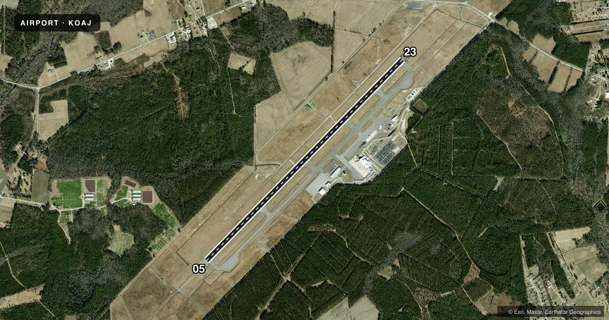
Airport sketch
Runways drawn to scale from FAA survey coordinates, rendered over satellite imagery. Not for navigation.
Approaches & charts
ILS · 1
Services on the field
Fuel grades, oxygen, maintenance, ramp storage and lighting — as declared to the FAA by the airport operator.
Fuel & services
- Fuel
- 100LLA
- Oxygen (bottled)
- Not available
- Oxygen (bulk)
- Not available
- Airframe repair
- Major
- Power plant repair
- Major
- Other services
- INSTR,RNTL,SALES
Ramp & ground
- Transient storage
- Tie-down
- Hangar
- Landing fee
- No fee published
- Customs
- Not available
- Lighting schedule
- SEE RMK
- Beacon schedule
- SS-SR
- Beacon
- White / Green (civil land)(WG)
- Wind indicator
- Lighted
- Segmented circle
- Yes
Fuel & FBOs
Cheapest 100LL and Jet A on the field and nearby. Always confirm with the FBO before taxi.
Airport notes
Surface conditions, obstructions, local procedures, lighting outages and other notes published with each FAA cycle.
General notes
- 180 DEG TURNS ON RWY 05/23 NA FOR ACFT 60000 LBS AND OVER.
- CLSD TO ALL MIL ACFT OVER 17000 LBS FOR ACR RAMP OPNS EXCP 24 HR PPR. CALL AMGR 910-324-1100 OR 910-989-3168.
- INDEX B ARFF COVERAGE PROVIDED DURING COMMERCIAL AIR TRC OPS. INDEX C AVAILABLE UPON REQ.
- FIELD CONDITIONS NOT MONITORED 0000LCL-0500LCL DAILY.
- FOR CD WHEN ATCT CLSD, CTC WILMINGTON APCH AT 910-815-4676, OR WHEN APCH CLSD CTC WASHINGTON ARTCC AT 703-771-3587.
Lighting notes
- ACTVT MALSR RWY 05; REIL RWY 23; PAPI RWY 05 & 23; HIRL RWY 05/23 - CTAF.
Fuel notes
- 100LLFOR FUEL OTHER HRS CALL 910-347-8366.
Runway surface & condition
- 05/23PCR VALUE: 590/F/A/W/T
Other notes
- CLSD TO UNSKED ACR OPNS WITH MORE THAN 30 PSGR SEATS EXCP PPR CALL AMGR 910-324-1100 OR 910-989-3168.
VFR map & nearby airports
VFR sectional. Tap any ICAO chip to open that airport.
Key facts · KOAJ
Answer card- ICAO
- KOAJ
- Name
- ALBERT J ELLIS
- Location
- JACKSONVILLE, NORTH CAROLINA
- Elevation
- 92.9 ft MSL
- Traffic pattern altitude
- 1,092.9 ft MSL (1,000 AGL)
- Control tower
- Towered · 0700-2200
- Total runways
- 1
- Longest runway
- 05/23 · 7,100 ft
- Published ILS approaches
- 1
- Published frequencies
- 10
- Magnetic variation
- 8°
- Current flight rules
- VFR
- Current wind
- 200° at 4 kt
- Favored runway now
- RWY 23
Albert J Ellis is in Jacksonville, North Carolina. The field elevation is 92.9 ft MSL. KOAJ has one runway, 05/23, at 7,100 ft. The airport has a control tower. Tower hours are 0700 to 2200. An ILS is published for runway 05. Pattern altitude is not published, so plan to verify the current traffic pattern altitude before arrival. For light piston traffic, use the standard 1,000 ft AGL pattern unless the current Chart Supplement says otherwise.
Skyport Aviation is on the field. It carries 100LL, Jet A and Jet A Prist. Call the FBO directly at (910) 324-2500 for current service details. Published remarks also note that MALSR is on runway 05. REIL is on runway 23. PAPI is available on both ends. High intensity runway lighting is available on 05/23. Use CTAF for lighting activation.
This is a controlled field with a single long runway. That helps with performance planning. The published remarks also note restricted access for some military and unscheduled air carrier operations. If you are operating anything unusual, call the airport manager before you go. Field conditions are not monitored from 0000 local time to 0500 local time daily. Check the airport or FBO directly if you are arriving in that window.