METAR & TAF KEWN
Current METAR
Observed 15:05Z
KEWN 271505Z VRB04KT 10SM BKN023 BKN034 OVC065 28/23 A2988 RMK AO2 T02830228
- Wind
- VAR @ 4 kt
- Visibility
- 10 SM
- Temp / Dew
- 28°C / 23°C
- Altimeter
- 29.88 inHg
- Clouds
- OVC
- Density alt
- 1,632 ft
- Ceiling
- 2,300 ft AGL
- Rules
- MVFR
Airport info & contacts
Manager on record, flight service, ARTCC, attendance schedule and pattern altitude — published by the FAA and refreshed every 28 days.
Location
- From city
- 3 NM SE
- VFR sectional
- CHARLOTTE
- ARTCC
- ZDC · WASHINGTON
- NOTAM facility
- EWN (NOTAM-D)
Airport manager
- Name
- ANDREW SHORTER
- Phone
- 252-638-8591
- Address
- 200 TERMINAL DRIVE, NEW BERN NC 28562-6455
Flight service · Hours
- FSS RDU
- RALEIGH1-800-WX-BRIEF
- Attendance
- 0500-2330
Frequencies
Tap any row to copy the frequency to your clipboard.
Runways & pattern
Full pagePattern entry · RWY 04
LEFT TRAFFIC| Runway | Heading (°M) | Length | Surface | Traffic |
|---|---|---|---|---|
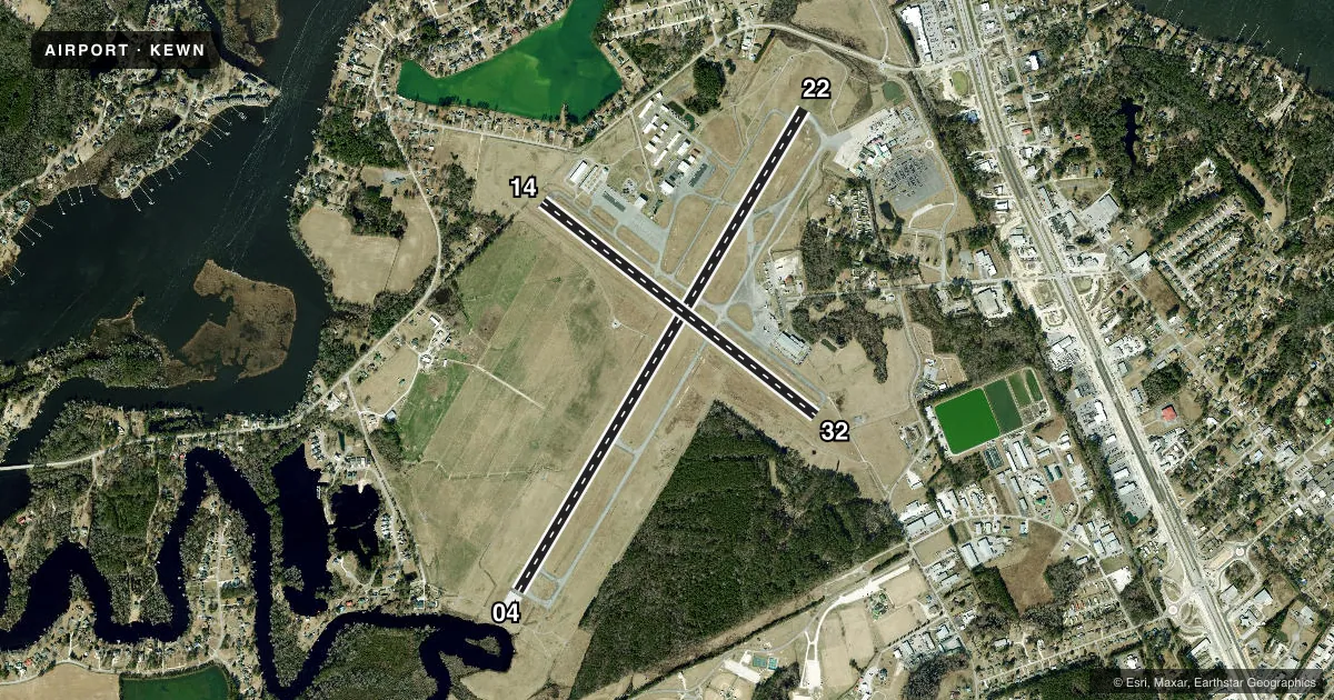
| 04/22Favored | 23° / 203° | 6,452 ft | ASPH | Standard L |
| 14/32 | 120° / 300° | 4,001 ft | ASPH | Standard L |
Runway end performance
| End | TORA | TODA | ASDA | LDA | VGSI | Approach lights | Obstruction |
|---|---|---|---|---|---|---|---|
| 04 | 6,453' | 6,453' | 6,053' | 5,753' | PAPI 4-box left(3°) | — | — |
| 22 | 6,453' | 6,453' | 6,153' | 6,153' | PAPI 4-box left(3°) | — | 68', trees, 2543' from thr, 558' R of cntrln, slope 34 |
| 14 | — | — | — | — | PAPI 2-box left(4°) | — | 28', trees, 1000' from thr, 500' R of cntrln, slope 20 |
| 32 | — | — | — | — | PAPI 2-box left(3°) | — | 26', tree, 862' from thr, 80' R of cntrln, slope 25 |
Declared distances in feet. TORA = takeoff run available, TODA = takeoff distance, ASDA = accelerate-stop, LDA = landing distance.
Airport sketch
Runways drawn to scale from FAA survey coordinates, rendered over satellite imagery. Not for navigation.
Approaches & charts
ILS · 1
Services on the field
Fuel grades, oxygen, maintenance, ramp storage and lighting — as declared to the FAA by the airport operator.
Fuel & services
- Fuel
- 100LLA
- Oxygen (bottled)
- Not available
- Oxygen (bulk)
- Not available
- Airframe repair
- Major
- Power plant repair
- Major
- Other services
- AFRT,CARGO,CHTR,INSTR,RNTL
Ramp & ground
- Transient storage
- Tie-down
- Hangar
- Landing fee
- No fee published
- Customs
- Not available
- Lighting schedule
- SEE RMK
- Beacon schedule
- SS-SR
- Beacon
- White / Green (civil land)(WG)
- Wind indicator
- Lighted
- Segmented circle
- No
Fuel & FBOs
Cheapest 100LL and Jet A on the field and nearby. Always confirm with the FBO before taxi.
Airport notes
Surface conditions, obstructions, local procedures, lighting outages and other notes published with each FAA cycle.
General notes
- MIL TACTICAL JET ACFT; STRAIGHT IN, FULL STOP LDGS ONLY; RWY 14/32 FOR EUO.
- RWY 14/32 ASSOCD TWYS NOT AVBL FOR SKED ACR OPNS WITH MORE THAN 9 PSGR SEATS OR UNSKED ACR AT LEAST 31 PSGR SEATS.
Lighting notes
- ACTVT REIL RWY 04, 22, 14 & 32; HIRL 04/22; MIRL 14/32 - CTAF. PAPI RWY 04, 22, 14 & 32 OPER CONSLY.
Runway surface & condition
- 04/22PCR VALUE: 250/F/B/X/T
- 14/32PCR VALUE: 250/F/C/X/T
- 14/32RWY 14/32 NOT AVBL FOR PART 121/PART 380 OPS WITH SKED PAX CARRYING OPS MORE THAN 9 PAX SEATS AND NON-SKED PAX CARRYING OPS MORE THAN 30 PAX SEATS.
Arresting gear
- 22_EMASARRESTING GEAR/SYSTEM: ENGINEERED MATERIALS ARRESTING SYSTEM (EMAS) 279.42 FT IN LENGTH BY 162 FT IN WIDTH LOCATED AT THE DEPARTURE END OF RWY 22.
Other notes
- ESTAB PRIOR 1958.
- CLSD TO UNSKED ACR OPNS WITH MORE THAN 30 PSGR SEATS EXCP 24 HR PPR CALL AMGR 252-638-8591.
VFR map & nearby airports
VFR sectional. Tap any ICAO chip to open that airport.
Key facts · KEWN
Answer card- ICAO
- KEWN
- Name
- COASTAL CAROLINA RGNL
- Location
- NEW BERN, NORTH CAROLINA
- Elevation
- 17.9 ft MSL
- Traffic pattern altitude
- 1,017.9 ft MSL (1,000 AGL)
- Control tower
- Towered · 0600-2200
- Total runways
- 2
- Longest runway
- 04/22 · 6,452 ft
- Published ILS approaches
- 1
- Published frequencies
- 8
- Magnetic variation
- 8°
- Current flight rules
- MVFR
- Current wind
- 000° at 4 kt
- Favored runway now
- RWY 04
Coastal Carolina Rgnl is in New Bern, North Carolina. The field elevation is 17.9 ft MSL. KEWN has 2 asphalt runways. The longest is runway 04/22 at 6,452 ft. The tower is open daily from 0600 to 2200. One ILS approach is published for runway 04.
Pattern altitude is not published in the facts. Use the current FAA Chart Supplement before you fly. Tidewater Air Services is on the field. It carries 100LL and Jet A with Prist. The airport sits near the coast, so expect low elevation operations with little terrain relief. The published remarks also note that runway 14/32 is for emergency use only. Runway 22 has engineered arresting gear at the departure end. Military tactical jet traffic is limited to straight-in, full-stop landings.
Runway lighting is worth a look before night work. Runway end identifier lights are active on all four runway ends. Runways 04 and 22 have high intensity lighting. Runways 14 and 32 have medium intensity lighting controlled by CTAF. PAPI is available on all runway ends. The airport also has published restrictions for larger passenger-carrying operations. Check the current FAA Chart Supplement and call the airport manager if your flight is outside normal general aviation use.