METAR & TAF KMQI
Current METAR
Observed 17:15Z
KMQI 271715Z AUTO 18008KT 10SM CLR 25/20 A2988 RMK AO2 T02510201
- Wind
- 180° @ 8 kt
- Visibility
- 10 SM
- Temp / Dew
- 25°C / 20°C
- Altimeter
- 29.88 inHg
- Clouds
- CLR
- Density alt
- 1,265 ft
- Ceiling
- Unlimited
- Rules
- VFR
Airport info & contacts
Manager on record, flight service, ARTCC, attendance schedule and pattern altitude — published by the FAA and refreshed every 28 days.
Location
- From city
- 1 NM NW
- VFR sectional
- CHARLOTTE
- ARTCC
- ZDC · WASHINGTON
- NOTAM facility
- MQI (NOTAM-D)
Airport manager
- Name
- STACY AMBROSE
- Phone
- 252-475-5571
- Address
- 410 AIRPORT ROAD, MANTEO NC 27954-9110
Flight service · Hours
- FSS RDU
- RALEIGH1-800-WX-BRIEF
- Attendance
- 0800-1900
Frequencies
Tap any row to copy the frequency to your clipboard.
Runways & pattern
Full pagePattern entry · RWY 17
LEFT TRAFFIC| Runway | Heading (°M) | Length | Surface | Traffic |
|---|---|---|---|---|
| 05/23 | 29° / 209° | 4,306 ft | ASPH | Standard L |
| 17/35Favored | 149° / 329° | 3,303 ft | ASPH | Standard L |
Runway end performance
| End | TORA | TODA | ASDA | LDA | VGSI | Approach lights | Obstruction |
|---|---|---|---|---|---|---|---|
| 05 | — | — | — | — | PAPI 4-box left(3°) | — | — |
| 23 | — | — | — | — | PAPI 4-box left(4°) | — | 25', bldg, 301' from thr, 262' R of cntrln, slope 4 |
| 17 | — | — | — | — | — | — | 67', trees, 364' from thr, 261' R of cntrln, slope 2 |
| 35 | — | — | — | — | — | — | 80', trees, 615' from thr, 206' R of cntrln, slope 5 |
Declared distances in feet. TORA = takeoff run available, TODA = takeoff distance, ASDA = accelerate-stop, LDA = landing distance.
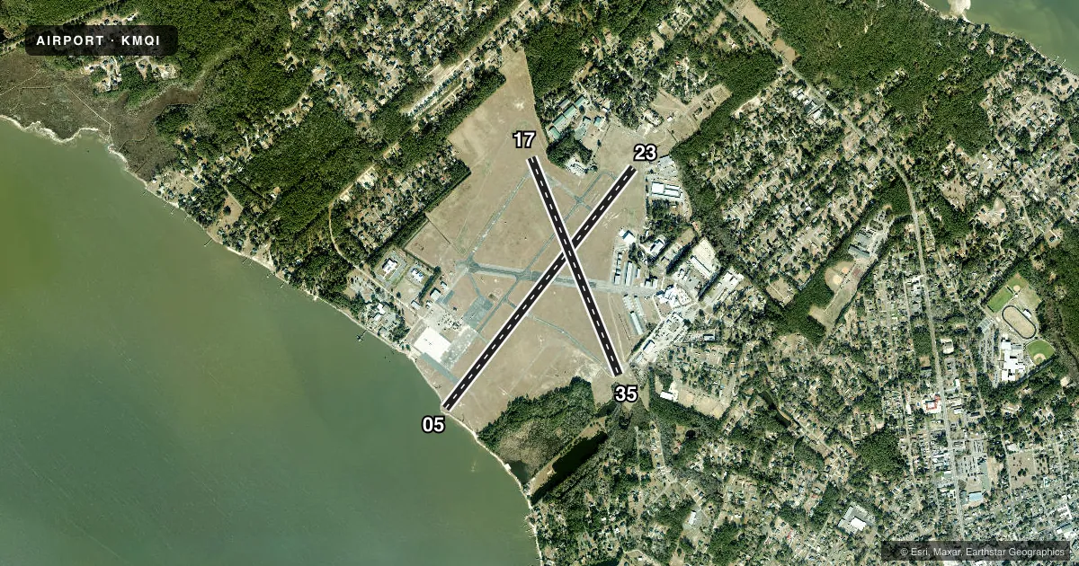
Airport sketch
Runways drawn to scale from FAA survey coordinates, rendered over satellite imagery. Not for navigation.
Approaches & charts
Services on the field
Fuel grades, oxygen, maintenance, ramp storage and lighting — as declared to the FAA by the airport operator.
Fuel & services
- Fuel
- 100LLA1+
- Oxygen (bottled)
- Not available
- Oxygen (bulk)
- Not available
- Airframe repair
- Major
- Power plant repair
- Major
- Other services
- AFRT,AMB,CHTR,INSTR,PAJA,RNTL
Ramp & ground
- Transient storage
- Tie-down
- Hangar
- Landing fee
- No fee published
- Customs
- Not available
- Lighting schedule
- SEE RMK
- Beacon schedule
- SS-SR
- Beacon
- White / Green (civil land)(WG)
- Wind indicator
- Lighted
- Segmented circle
- Yes
Fuel & FBOs
Cheapest 100LL and Jet A on the field and nearby. Always confirm with the FBO before taxi.
Airport notes
Surface conditions, obstructions, local procedures, lighting outages and other notes published with each FAA cycle.
General notes
- RWY 05 15 FT DROP-OFF 40 FT FM THR 0B.
- MIGRATORY WATERFOWL OCT - FEB.
- BANNER TOWING OPNS 200 FT W OF RWY 05.
- SEAPLANE RAMP NEAR APRON.
- TWY F CLSD PERMLY.
- FOR CD CTC CHERRY POINT APCH AT 252-466-5960, OR WHEN APCH CLSD CTC WASHINGTON ARTCC AT 703-771-3587.
Lighting notes
- PAPI RWY 05 & 23 OPR CONSLY, SS-SR - CTAF. ACTVT REIL RWY 05, 23; MIRL RWY 05/23 & 17/35 - CTAF.
Fuel notes
- 100LL100LL AVBL AFT HRS SELF SVC WITH CREDIT CARD.
Approach & departure obstructions
- 237 FT FENCE 100-300 FT FM END OF PAVEMENT BOTH SIDES OF CNTRLN; 15 FT ROAD 90 FT FM END OF PAVEMENT AND BOTH SIDES OF CNTRLN; 12 FT TRUCK 193 FT FM END OF PAVEMENT OFFSET 120 FT LEFT OF CNTRLN.
- 359 FT BRUSH 131 FT FM END OF PAVEMENT OFFSET 16 FT RIGHT OF CNTRLN.
- 17APCH SLOPE 6:1 AT DSPLCD.
- 23APCH SLOPE 11:1 AT DSPLCD THR DUE TO 15 FT ROAD 378 FT FM DSPLCD THR AND BOTH SIDES OF CNTRLN.
- 35APCH SLOPE 16:1 AT DSPLCD THR DUE TO 86 FT TREES 1597 FT FM DSPLCD THR OFFSET 154 FT RIGHT OF CNTRLN.
Other notes
- BUILT PRIOR TO 1958.
- 1UNATNDD CHRISTMAS DAY. FOR SVC AFT HRS CALL 252-216-7028 OR 252-216-8407.
VFR map & nearby airports
VFR sectional. Tap any ICAO chip to open that airport.
Key facts · KMQI
Answer card- ICAO
- KMQI
- Name
- DARE COUNTY RGNL
- Location
- MANTEO, NORTH CAROLINA
- Elevation
- 12.8 ft MSL
- Traffic pattern altitude
- 1,012.8 ft MSL (1,000 AGL)
- Control tower
- Non-towered (use CTAF)
- Total runways
- 2
- Longest runway
- 05/23 · 4,306 ft
- Published ILS approaches
- 0
- Published frequencies
- 4
- Magnetic variation
- 9°
- Current flight rules
- VFR
- Current wind
- 180° at 8 kt
- Favored runway now
- RWY 17
Dare County Regional Airport sits in Manteo, North Carolina. Field elevation is 12.8 ft MSL. It has two asphalt runways. The longest is 4,306 ft on runway 05/23. There is no control tower. CTAF and UNICOM are both 122.8. Approach and departure service is through Cherry Point.
No ILS approaches are published here. Pattern altitude is not published in the facts, so use the current Chart Supplement before you go. The airport sits low and close to the coast. Expect waterfowl activity from October through February. Banner towing also occurs 200 feet west of runway 05. Taxiway F is closed permanently.
The on-field FBO is Dare County Regional Airport. It carries 100LL and Jet A Prist. After-hours self-serve 100LL is available with a credit card. The published remarks also call out displaced-threshold obstacle notes on all three runway ends. That matters here. Runway 05 has a road close in on the approach side. Runway 35 has trees on the approach path. Runway 17 also has a steep approach-slope note at the displaced threshold. If you are planning a first stop here, review the current Chart Supplement and brief the runway environment carefully before arrival.