METAR & TAF KRDU
Current METAR
Observed 13:29Z
KRDU 271329Z 34006KT 10SM FEW008 25/23 A2987 RMK AO2 T02500228
- Wind
- 340° @ 6 kt
- Visibility
- 10 SM
- Temp / Dew
- 25°C / 23°C
- Altimeter
- 29.87 inHg
- Clouds
- FEW
- Density alt
- 1,802 ft
- Ceiling
- Unlimited
- Rules
- VFR
Airport info & contacts
Manager on record, flight service, ARTCC, attendance schedule and pattern altitude — published by the FAA and refreshed every 28 days.
Location
- From city
- 9 NM NW
- VFR sectional
- CHARLOTTE
- ARTCC
- ZDC · WASHINGTON
- NOTAM facility
- RDU (NOTAM-D)
Airport manager
- Name
- MICHAEL LANDGUTH
- Phone
- (919) 840-7701
- Address
- RALEIGH-DURHAM ARPT AUTH, P.O. BOX 80001, RDU AIRPORT NC 27623
Flight service · Hours
- FSS RDU
- RALEIGH1-800-WX-BRIEF
- Attendance
- ALL
Frequencies
Tap any row to copy the frequency to your clipboard.
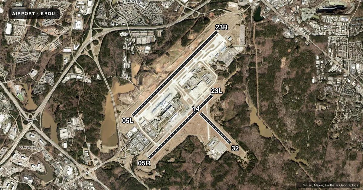
Runways & pattern
Full pagePattern entry · RWY 32
LEFT TRAFFIC| Runway | Heading (°M) | Length | Surface | Traffic |
|---|---|---|---|---|
| 05L/23R | 36° / 216° | 10,000 ft | CONC | 23R R |
| 05R/23L | 36° / 216° | 7,500 ft | ASPH | 05R R |
| 14/32Favored | 126° / 306° | 3,570 ft | ASPH | Standard L |
Runway end performance
| End | TORA | TODA | ASDA | LDA | VGSI | Approach lights | Obstruction |
|---|---|---|---|---|---|---|---|
| 05L | 10,000' | 10,000' | 10,000' | 10,000' | PAPI 4-box left(3°) | MALSR | — |
| 23R | 10,000' | 10,000' | 10,000' | 10,000' | PAPI 4-box left(3°) | ALSF2 | — |
| 05R | 7,500' | 7,500' | 7,500' | 7,500' | PAPI 4-box left(3°) | MALSR | — |
| 23L | 7,500' | 7,500' | 7,500' | 7,500' | PAPI 4-box left(3°) | MALSR | — |
| 32 | — | — | — | — | PAPI 4-box left(3.5°) | — | 120', trees, 3046' from thr, 1' R of cntrln, slope 24 |
Declared distances in feet. TORA = takeoff run available, TODA = takeoff distance, ASDA = accelerate-stop, LDA = landing distance.
Airport sketch
Runways drawn to scale from FAA survey coordinates, rendered over satellite imagery. Not for navigation.
Approaches & charts
ILS · 4
Services on the field
Fuel grades, oxygen, maintenance, ramp storage and lighting — as declared to the FAA by the airport operator.
Fuel & services
- Fuel
- 100LLA
- Oxygen (bottled)
- Not available
- Oxygen (bulk)
- HIGH/LOW
- Airframe repair
- Major
- Power plant repair
- Major
- Other services
- AFRT,AMB,AVNCS,CARGO,CHTR,INSTR,RNTL,SALES,SURV
Ramp & ground
- Transient storage
- Tie-down
- Hangar
- Landing fee
- No fee published
- Customs
- Not available
- Lighting schedule
- SS-SR
- Beacon schedule
- SS-SR
- Beacon
- White / Green (civil land)(WG)
- Wind indicator
- Lighted
- Segmented circle
- No
Fuel & FBOs
Cheapest 100LL and Jet A on the field and nearby. Always confirm with the FBO before taxi.
Airport notes
Surface conditions, obstructions, local procedures, lighting outages and other notes published with each FAA cycle.
General notes
- NO JET ENGINE MAINTENANCE RUNS BETWEEN 0000-0600.
- NG PPR FOR LDG CTC V582-9181 C(919)664-9181.
- NG 24 HR PPR FOR JET ACFT & TRANS MIL ACFT - 919-840-7510.
- RSTD: PPR FOR ALL MILITARY AIRCRAFT F/W - R/W & UNSCHEDULED CHARTER FLIGHTS WITH 30 OR MORE PASSENGERS. 24 HR PN RQR FOR MIL PRACTICE APCH. CTC ARPT OPS 919-840-7510 OR RDU APP C919-380-3125. 24 HR PN RQR FOR PPR FOR ALL F/W AND R/W MIL ACFT GOING TO ARNG RAMP, POC C984-661-6200. OSACOM FLT DET C984-661-6202.
- ARPT CLSD TO AIRSHIPS.
- TWY E BEHIND SOUTH CARGO 4 & TWY J BEHIND CORPORATE HANGARS NOT VSBL FM ATCT.
- ARNG: LTD PRK. ARNG OPS C984-661-6200. CTC FORECAST BASE 10 MIN PRIOR LDG. RAMP CLSD TO ALL F/W EXCEPT ARMY & MIL TRANSPORT WITH PPR, FACILITY HRS 1300-2130Z++ MON-FRI EXC HOL. MAKE APPT FOR AFTER DUTY HRS. OSACOM FLT DET C984-661-6202.
- TWY F4 & F5 IS CLSD UFN.
- ALL TDG V AIRCRAFT TXG ON TWY A ARE RSTD TO TAXI SPD OF 15 MPH.
- APN TXL F BTN TWY T1 AND TWY T7 CLSD TO ACFT WITH WINGSPAN MORE THAN 171 FT.
- TWY D CLSD TO ACFT WITH WINGSPAN MORE THAN 171 FT WHEN TWY G AND H ARE OCCUPIED.
- TRML 1 ACFT MUST CTC ATC ON 121.9 PRIOR TO PUSH ONTO TWY A. TRML 2 ACFT MUST CTC RAMP TWR ON 130.175 PRIOR TO PUSH. NORTH CARGO APRON ADG IV OR V ACFT MUST CTC ATC ON 121.9 PRIOR TO PUSH.
- TWY C BTN TWY F AND G IS RSTRD TO ACFT LESS THAN A MAX GROSS TKOF WEIGHT OF 490000 LBS.
- TWY E CLSD TO AFCT WITH WINGSPAN MORE THAN 171 FT.
Lighting notes
- VISIBILITY OF BCN SHIELDED TO THE NORTH.
Runway surface & condition
- 05L/23RPCR VALUE: 801/R/B/W/T
- 05R/23LPCR VALUE: 783/F/C/X/T
- 05L/23RRWY 05L/23R UNGROOVED.
VFR map & nearby airports
VFR sectional. Tap any ICAO chip to open that airport.
Key facts · KRDU
Answer card- ICAO
- KRDU
- Name
- RALEIGH-DURHAM INTL
- Location
- RALEIGH/DURHAM, NORTH CAROLINA
- Elevation
- 435.2 ft MSL
- Traffic pattern altitude
- 1,435.2 ft MSL (1,000 AGL)
- Control tower
- Towered · 24
- Total runways
- 3
- Longest runway
- 05L/23R · 10,000 ft
- Published ILS approaches
- 4
- Published frequencies
- 21
- Magnetic variation
- 9°
- Current flight rules
- VFR
- Current wind
- 340° at 6 kt
- Favored runway now
- RWY 32
Raleigh-Durham Intl sits in Raleigh and Durham, North Carolina. Field elevation is 435.2 ft MSL. The airport has 3 runways. The longest is 10,000 ft on 05L/23R. Tower service is 24 hours. Four ILS approaches are published for the 05L, 05R, 23L and 23R runway ends.
Pattern altitude is not published in the facts. Use the current FAA Chart Supplement before you fly the pattern. This is a busy Class C field. Expect standard radar procedures and active coordination on the ground and in the air. The beacon is shielded to the north. Runway 05L/23R is ungrooved. Plan for that in wet conditions.
Atlantic Aviation is on the field. It carries 100LL and Jet A. Signature Aviation is also on the field. It carries 100LL, Jet A and Jet A Prist. Taxi and ramp details matter here. Taxiway A has a 15 mph limit. Taxiway E behind South Cargo 4 and taxiway J behind the corporate hangars are not visible from the tower. Some taxiways and apron areas are closed or restricted. Review the current Chart Supplement and coordinate with airport operations if you are bringing in a large aircraft or a military flight.