METAR & TAF KTTA
Current METAR
Observed 11:35Z
KTTA 271135Z AUTO 00000KT 7SM CLR 21/21 A2988 RMK AO2 T02100210
- Wind
- 000° @ 0 kt
- Visibility
- 7 SM
- Temp / Dew
- 21°C / 21°C
- Altimeter
- 29.88 inHg
- Clouds
- CLR
- Density alt
- 1,075 ft
- Ceiling
- Unlimited
- Rules
- VFR
Airport info & contacts
Manager on record, flight service, ARTCC, attendance schedule and pattern altitude — published by the FAA and refreshed every 28 days.
Location
- From city
- 7 NM NE
- VFR sectional
- CHARLOTTE
- ARTCC
- ZDC · WASHINGTON
- NOTAM facility
- TTA (NOTAM-D)
Airport manager
- Name
- BOB HEUTS
- Phone
- 919-776-2939
- Address
- 700 ROD SULLIVAN RD., SANFORD NC 27330
Flight service · Hours
- FSS RDU
- RALEIGH1-800-WX-BRIEF
- Attendance
- MON-FRI · 0700-1800
- SAT-SUN · 0800-1800
Frequencies
Tap any row to copy the frequency to your clipboard.
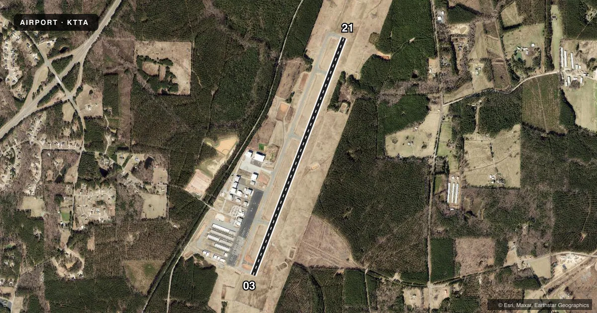
Runways & pattern
Full pagePattern entry · RWY 03
LEFT TRAFFICRunway end performance
| End | TORA | TODA | ASDA | LDA | VGSI | Approach lights | Obstruction |
|---|---|---|---|---|---|---|---|
| 03 | — | — | — | — | PAPI 4-box left(3°) | MALSR | — |
| 21 | — | — | — | — | PAPI 4-box left(3°) | — | 31', trees, 1673' from thr, 117' R of cntrln, slope 47 |
Declared distances in feet. TORA = takeoff run available, TODA = takeoff distance, ASDA = accelerate-stop, LDA = landing distance.
Airport sketch
Runways drawn to scale from FAA survey coordinates, rendered over satellite imagery. Not for navigation.
Approaches & charts
ILS · 1
Services on the field
Fuel grades, oxygen, maintenance, ramp storage and lighting — as declared to the FAA by the airport operator.
Fuel & services
- Fuel
- 100LLA1+
- Oxygen (bottled)
- High pressure
- Airframe repair
- Major
- Power plant repair
- Major
- Other services
- AVNCS,CARGO,CHTR,INSTR,RNTL,SALES
Ramp & ground
- Transient storage
- Tie-down
- Lighting schedule
- SEE RMK
- Beacon schedule
- SS-SR
- Beacon
- White / Green (civil land)(WG)
- Wind indicator
- Lighted
- Segmented circle
- Yes
Fuel & FBOs
Cheapest 100LL and Jet A on the field and nearby. Always confirm with the FBO before taxi.
Airport notes
Surface conditions, obstructions, local procedures, lighting outages and other notes published with each FAA cycle.
General notes
- FOR CD CTC RALEIGH APCH AT 919-380-3144.
- USE RWY 03 FOR CALM WIND RWY.
- TWY A 15-30 FT DROP-OFF INVOF TWYS A3 AND A4.
Lighting notes
- DUSK-DAWN. ACTVT MALSR RWY 03; REIL RWY 21; HIRL RWY 03/21 - CTAF. PAPI RWYS 03 & 21 ON CONSLY.
Fuel notes
- 100LL100LL 24 HR SELF-SVC WITH CREDIT CARD.
Approach & departure obstructions
- 03PAPI UNUSBL BYD 8 DEGS LEFT OF CNTRLN.
Other notes
- 1FOR SVC AFTER HOURS CALL 919-708-3065.
- CARGOCARGO SVC ON DEMAND.
VFR map & nearby airports
VFR sectional. Tap any ICAO chip to open that airport.
Key facts · KTTA
Answer card- ICAO
- KTTA
- Name
- RALEIGH EXEC JETPORT AT SANFORD-LEE COUNTY
- Location
- SANFORD, NORTH CAROLINA
- Elevation
- 246.6 ft MSL
- Traffic pattern altitude
- 1,246.6 ft MSL (1,000 AGL)
- Control tower
- Non-towered (use CTAF)
- Total runways
- 1
- Longest runway
- 03/21 · 6,501 ft
- Published ILS approaches
- 1
- Published frequencies
- 4
- Magnetic variation
- 8°
- Current flight rules
- VFR
- Current wind
- 000° at 0 kt
- Favored runway now
- –
Raleigh Executive Jetport at Sanford-Lee County sits in Sanford, North Carolina. Field elevation is 246.6 ft MSL. The airport has one runway. It is 03/21 and it is 6,501 ft long. There is no control tower. Pattern altitude is not published, so light piston traffic should plan on the standard 1,000 ft AGL unless the current FAA Chart Supplement says otherwise.
The field has one ILS approach. It is for runway 03. Raleigh Approach handles clearance delivery. Published remarks also say to use runway 03 for calm wind operations. That matters here because the field has a single runway. The published lighting setup is tied to CTAF control at night. Lighting is dusk to dawn. Runway 03 has a MALSR. Runway 21 has REILs. High intensity runway lights are on both ends.
Raleigh Executive Jetport is home to Raleigh Executive Jetport FBO. It carries 100LL and Jet A. 100LL is available 24 hours self-service with credit card. Pilots should also note the taxiway A drop-off near A3 and A4. That is a real taxi hazard. The airport sits in the Raleigh area, so expect busy local traffic. Keep an eye on the current Chart Supplement for any updated procedures before you go.