METAR & TAF KSCR
Current METAR
Observed 13:15Z
KSCR 271315Z AUTO 00000KT 10SM CLR 24/23 A2989 RMK AO2 T02430225
- Wind
- 000° @ 0 kt
- Visibility
- 10 SM
- Temp / Dew
- 24°C / 23°C
- Altimeter
- 29.89 inHg
- Clouds
- CLR
- Density alt
- 1,881 ft
- Ceiling
- Unlimited
- Rules
- VFR
Airport info & contacts
Manager on record, flight service, ARTCC, attendance schedule and pattern altitude — published by the FAA and refreshed every 28 days.
Location
- From city
- 3 NM SW
- VFR sectional
- CHARLOTTE
- ARTCC
- ZTL · ATLANTA
- NOTAM facility
- RDU (NOTAM-D)
Airport manager
- Name
- KAREN MCCRAW
- Phone
- 919-742-3847
- Address
- 80 AVIATION DR., SILER CITY NC 27344
Flight service · Hours
- FSS RDU
- RALEIGH1-800-WX-BRIEF
- Attendance
- MON-SAT · 0900-1700
- SUN · 1200-1700
Frequencies
Tap any row to copy the frequency to your clipboard.
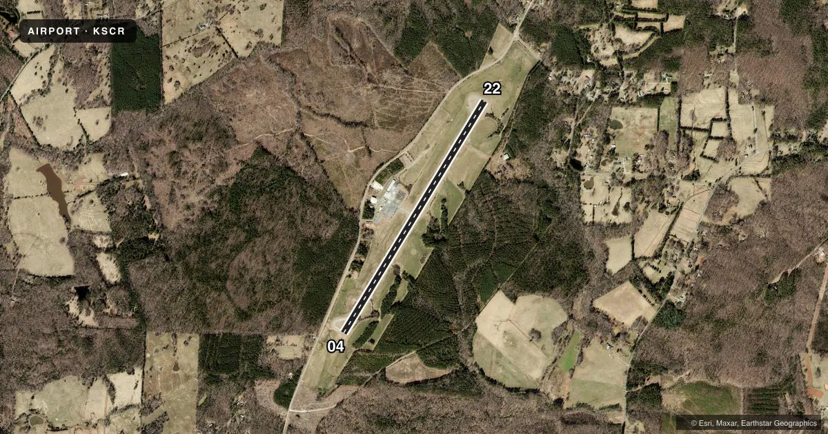
Runways & pattern
Full pagePattern entry · RWY 04
LEFT TRAFFICRunway end performance
| End | TORA | TODA | ASDA | LDA | VGSI | Approach lights | Obstruction |
|---|---|---|---|---|---|---|---|
| 04 | — | — | — | — | PAPI 4-box left(4.2°) | — | 45', trees, 1183' from thr, 247' R of cntrln, slope 21 |
| 22 | — | — | — | — | PAPI 4-box left(3.5°) | — | 48', trees, 1283' from thr, 249' R of cntrln, slope 22 |
Declared distances in feet. TORA = takeoff run available, TODA = takeoff distance, ASDA = accelerate-stop, LDA = landing distance.
Airport sketch
Runways drawn to scale from FAA survey coordinates, rendered over satellite imagery. Not for navigation.
Approaches & charts
Services on the field
Fuel grades, oxygen, maintenance, ramp storage and lighting — as declared to the FAA by the airport operator.
Fuel & services
- Fuel
- 100LLA1+
- Oxygen (bulk)
- Not available
- Airframe repair
- Major
- Power plant repair
- Major
- Other services
- INSTR,RNTL
Ramp & ground
- Transient storage
- Tie-down
- Landing fee
- No fee published
- Customs
- Not available
- Lighting schedule
- SEE RMK
- Beacon schedule
- SS-SR
- Beacon
- White / Green (civil land)(WG)
- Wind indicator
- Lighted
- Segmented circle
- Yes
Fuel & FBOs
Cheapest 100LL and Jet A on the field and nearby. Always confirm with the FBO before taxi.
Airport notes
Surface conditions, obstructions, local procedures, lighting outages and other notes published with each FAA cycle.
General notes
- AFT HRS FUEL OR SVCS, CALL 919-619-2707.
- DEER & BIRDS ON & INVOF ARPT.
- ASPH SECTION OF RAMP PAVEMENT STRENGTH IS CSDRBLY LESS THAN RWY.
- SEASONAL FARMING OPNS AND EQPT INVOF RWY.
- FOR CD CTC GREENSBORO APCH AT 336-333-5119.
Lighting notes
- ACTVT REILS RWY 04 & 22; MIRL RWY 04/22 - CTAF. PAPI RWY 04 & 22 OPER CONSLY.
Fuel notes
- 100LL24 HR CREDIT CARD SVC AVBL FOR 100LL AND JET A.
VFR map & nearby airports
VFR sectional. Tap any ICAO chip to open that airport.
Key facts · KSCR
Answer card- ICAO
- KSCR
- Name
- SILER CITY MUNI
- Location
- SILER CITY, NORTH CAROLINA
- Elevation
- 615.6 ft MSL
- Traffic pattern altitude
- 1,615.6 ft MSL (1,000 AGL)
- Control tower
- Non-towered (use CTAF)
- Total runways
- 1
- Longest runway
- 04/22 · 5,000 ft
- Published ILS approaches
- 0
- Published frequencies
- 4
- Magnetic variation
- 9°
- Current flight rules
- VFR
- Current wind
- 000° at 0 kt
- Favored runway now
- –
Siler City Muni sits in Siler City, North Carolina. The field elevation is 615.6 ft MSL. It has one runway, 04/22, which is 5,000 ft long. There is no control tower. CTAF and UNICOM are both 122.7. Greensboro Approach handles the published approach and departure frequencies. No ILS approaches are published here.
Pattern altitude is not published. Use 1,000 ft AGL as the standard light piston pattern unless local procedures or ATC say otherwise. For this field, that puts the pattern near 1,615.6 ft MSL. Cardinal Air is on the field. It carries 100LL and Jet A. After-hours fuel or services are available by calling the number in the Chart Supplement. Twenty-four hour credit card service is also published for 100LL and Jet A.
A first-time pilot should pay attention to the published remarks. Deer and birds are reported on and near the airport. Seasonal farming equipment is also in the vicinity of the runway. The asphalt section of ramp pavement is weaker than the runway, so taxi and park with that in mind. Runway end identifier lights are active on 04 and 22. Medium intensity runway lights are controlled by CTAF. Precision approach path indicators operate continuously on both runway ends.