METAR & TAF KBUY
Current METAR
Observed 12:21Z
KBUY 271221Z AUTO 31003KT 2SM BR OVC002 23/22 A2988 RMK AO2 T02280222
- Wind
- 310° @ 3 kt
- Visibility
- 2 SM
- Temp / Dew
- 23°C / 22°C
- Altimeter
- 29.88 inHg
- Clouds
- OVC
- Density alt
- 1,774 ft
- Ceiling
- 200 ft AGL
- Rules
- LIFR
Airport info & contacts
Manager on record, flight service, ARTCC, attendance schedule and pattern altitude — published by the FAA and refreshed every 28 days.
Location
- From city
- 3 NM SW
- VFR sectional
- CINCINNATI
- ARTCC
- ZTL · ATLANTA
- NOTAM facility
- BUY (NOTAM-D)
Airport manager
- Name
- DAN DANIELEY
- Phone
- 336-227-0771
- Address
- 3441. N AVIATION DRIVE, BURLINGTON NC 27215-6374
Flight service · Hours
- FSS RDU
- RALEIGH1-800-WX-BRIEF
- Attendance
- 0800-2000
Frequencies
Tap any row to copy the frequency to your clipboard.
Runways & pattern
Full pagePattern entry · RWY 24
LEFT TRAFFICRunway end performance
| End | TORA | TODA | ASDA | LDA | VGSI | Approach lights | Obstruction |
|---|---|---|---|---|---|---|---|
| 06 | — | — | — | — | PAPI 4-box left(3°) | — | 38', trees, 1161' from thr, 450' R of cntrln, slope 25 |
| 24 | — | — | — | — | PAPI 4-box left(3°) | — | 51', trees, 1505' from thr, 596' R of cntrln, slope 25 |
Declared distances in feet. TORA = takeoff run available, TODA = takeoff distance, ASDA = accelerate-stop, LDA = landing distance.
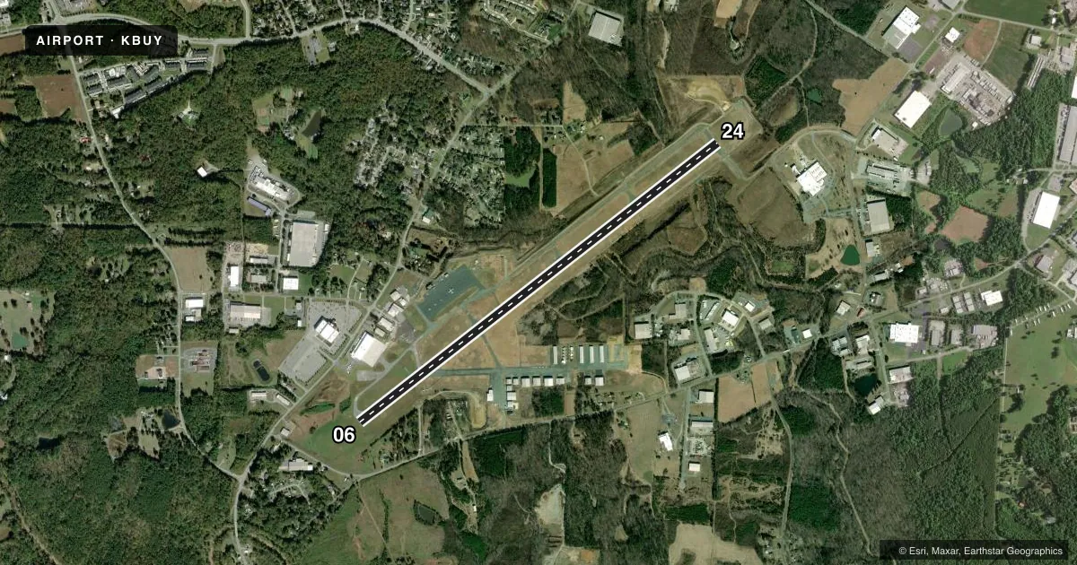
Airport sketch
Runways drawn to scale from FAA survey coordinates, rendered over satellite imagery. Not for navigation.
Approaches & charts
ILS · 1
Services on the field
Fuel grades, oxygen, maintenance, ramp storage and lighting — as declared to the FAA by the airport operator.
Fuel & services
- Fuel
- 100LLA1+
- Oxygen (bottled)
- High pressure
- Oxygen (bulk)
- Not available
- Airframe repair
- Major
- Power plant repair
- Major
- Other services
- AMB,CHTR,INSTR,RNTL,SALES
Ramp & ground
- Transient storage
- Tie-down
- Hangar
- Landing fee
- No fee published
- Customs
- Not available
- Lighting schedule
- SEE RMK
- Beacon schedule
- SS-SR
- Beacon
- White / Green (civil land)(WG)
- Wind indicator
- Lighted
- Segmented circle
- Yes
Fuel & FBOs
Cheapest 100LL and Jet A on the field and nearby. Always confirm with the FBO before taxi.
Airport notes
Surface conditions, obstructions, local procedures, lighting outages and other notes published with each FAA cycle.
General notes
- DEER AND WATERFOWL INVOF ARPT.
- RWY 06, 15 FT DROP-OFF 150 FT FM THR 250 FT LEFT OF CNTRLN.
- AFTER HRS FUEL OR EMERG ONLY 336-223-4994.
- FOR CD CTC GREENSBORO APCH AT 743-222-6129.
- RWY 24 HAS UNMKD HIGH VOLTAGE TRANSMISSION LINES APRXLY 4000 FT FROM THR AND BOTH SIDES OF CNTRLN.
Lighting notes
- ACTVT REIL RWY 06 & 24 - CTAF. PAPI RWY 06 & 24 OPER CONT. HIRL RWY 06/24 ON DUSK-DAWN, TO CHANGE INTST - CTAF.
Approach & departure obstructions
- 0616 FT TREES 116 FT FM END OF RWY OFFSET 363 FT RIGHT OF CNTRLN.
Other notes
- 3UNATNDD CHRISTMAS DAY.
- MANAGERARPT PH# 336-226-3330.
VFR map & nearby airports
VFR sectional. Tap any ICAO chip to open that airport.
Key facts · KBUY
Answer card- ICAO
- KBUY
- Name
- BURLINGTON/ALAMANCE RGNL
- Location
- BURLINGTON, NORTH CAROLINA
- Elevation
- 616.1 ft MSL
- Traffic pattern altitude
- 1,616.1 ft MSL (1,000 AGL)
- Control tower
- Non-towered (use CTAF)
- Total runways
- 1
- Longest runway
- 06/24 · 6,406 ft
- Published ILS approaches
- 1
- Published frequencies
- 5
- Magnetic variation
- 8°
- Current flight rules
- LIFR
- Current wind
- 310° at 3 kt
- Favored runway now
- RWY 24
Burlington/Alamance Rgnl Airport sits in Burlington, North Carolina. Field elevation is 616.1 ft MSL. The airport has one runway, 06/24, which is 6,406 ft long and paved with asphalt. There is no control tower. The published pattern altitude is not listed, so use the standard 1,000 ft AGL for light piston traffic unless the current Chart Supplement says otherwise. That puts the pattern at about 1,616 ft MSL.
KBUY has one ILS approach. It serves runway 06. CTAF and UNICOM are both 122.975. Greensboro Approach handles clearance delivery and approach or departure work on 126.6 and 327.075. SkySouth Aviation is the on-field FBO. It carries 100LL and Jet A Prist. The airport phone number is 336-226-3330.
A few published remarks matter here. Runway end identifier lights and PAPI for 06 and 24 are tied to CTAF. The runway lights are high intensity and can be adjusted on CTAF. Deer and waterfowl are reported in the area. Runway 06 has trees near the departure end. Runway 24 has unmarked high voltage transmission lines about 4,000 ft from the threshold on both sides of centerline. If you are planning a night or low-weather arrival, brief the ILS to 06 and review the lighting notes before you go.