METAR & TAF 6W4
6W4 does not publish a METAR.
Showing the nearest reporting station: KDAN (DANVILLE RGNL) · 10.7 NM away. Conditions at 6W4 may differ.
METAR · KDAN
Observed 15:53Z
KDAN 261553Z AUTO 10SM SCT018 BKN024 BKN065 26/21 A2997 RMK AO2 SLP140 T02610206 $
- Wind
- Calm
- Visibility
- 10 SM
- Temp / Dew
- 26°C / 21°C
- Altimeter
- 29.97 inHg
- Clouds
- BKN
- Density alt
- 2,062 ft
- Ceiling
- 2,400 ft AGL
- Rules
- MVFR
Airport info & contacts
Manager on record, flight service, ARTCC, attendance schedule and pattern altitude — published by the FAA and refreshed every 28 days.
Location
- From city
- 2 NM W
- VFR sectional
- CINCINNATI
- ARTCC
- ZDC · WASHINGTON
- NOTAM facility
- RDU (NOTAM-D)
Airport manager
- Name
- KAMARA BARNETT
- Phone
- 336-694-5431
- Address
- 158 EAST CHURCH STREET, POST OFFICE BOX 727, YANCEYVILLE NC 27379
Flight service · Hours
- FSS RDU
- RALEIGH1-800-WX-BRIEF
- Attendance
- Unattended
Frequencies
Tap any row to copy the frequency to your clipboard.
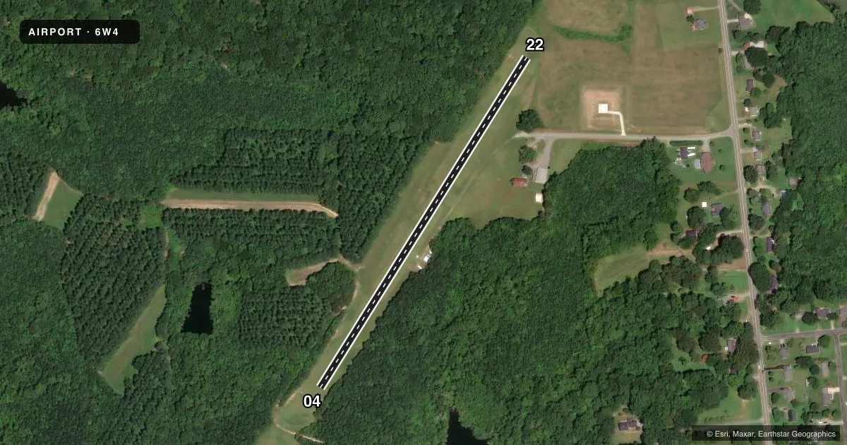
Runways & pattern
Full pagePattern entry · RWY 04
LEFT TRAFFICRunway end performance
| End | TORA | TODA | ASDA | LDA | VGSI | Approach lights | Obstruction |
|---|---|---|---|---|---|---|---|
| 04 | — | — | — | — | — | — | 29', trees, 17' from thr, 85' R of cntrln, slope 0 |
| 22 | — | — | — | — | — | — | 87', trees, 113' from thr, 125' R of cntrln, slope 1 |
Declared distances in feet. TORA = takeoff run available, TODA = takeoff distance, ASDA = accelerate-stop, LDA = landing distance.
Airport sketch
Runways drawn to scale from FAA survey coordinates, rendered over satellite imagery. Not for navigation.
Approaches & charts
Services on the field
Fuel grades, oxygen, maintenance, ramp storage and lighting — as declared to the FAA by the airport operator.
Fuel & services
- Fuel
- Not available
- Oxygen (bottled)
- Not available
- Oxygen (bulk)
- Not available
- Airframe repair
- Not available
- Power plant repair
- Not available
Ramp & ground
- Transient storage
- Not published
- Landing fee
- No fee published
- Wind indicator
- Yes
- Segmented circle
- No
Fuel & FBOs
Cheapest 100LL and Jet A on the field and nearby. Always confirm with the FBO before taxi.
Airport notes
Surface conditions, obstructions, local procedures, lighting outages and other notes published with each FAA cycle.
General notes
- DEER ON AND INVOF ARPT.
- FOR CD CTC WASHINGTON ARTCC AT 703-771-3587.
- RWY 04/22 +50-70 FT TREES ALONG BOTH SIDES OF RWY.
- OCNL NIGHTTIME MIL OPS.
Approach & departure obstructions
- 0404/22 ONLY RWY ENDS MARKED WITH YELLOW CONES.
- 04CTLNG OBSTN EXCEEDS A 45 DEG SLP.
Other notes
- EXISTED PRIOR TO 1959.
VFR map & nearby airports
VFR sectional. Tap any ICAO chip to open that airport.
Key facts · 6W4
Answer card- ICAO
- 6W4
- Name
- YANCEYVILLE MUNI
- Location
- YANCEYVILLE, NORTH CAROLINA
- Elevation
- 648 ft MSL
- Traffic pattern altitude
- 1,648 ft MSL (1,000 AGL)
- Control tower
- Non-towered (use CTAF)
- Total runways
- 1
- Longest runway
- 04/22 · 1,735 ft
- Published ILS approaches
- 0
- Published frequencies
- 1
- Magnetic variation
- 7°
- Current flight rules
- MVFR
- Current wind
- Calm / unavailable
- Favored runway now
- –
Yanceyville Muni sits in Yanceyville, North Carolina. The field elevation is 648 ft MSL. It has one runway. Runway 04/22 is 1,735 ft of turf, so performance margins are tight for heavier loads or soft-field conditions. The airport is non-towered. CTAF is 122.9. No ILS approaches are published here.
The pattern altitude is not published. Use 1,000 ft AGL for light piston operations unless the current Chart Supplement says otherwise. The runway ends are marked with yellow cones. Trees run 50 to 70 ft along both sides of the runway. Runway 04 also has a controlling obstruction that exceeds a 45 degree slope, so pay close attention on the approach path. Deer are reported on and near the airport. Occasional nighttime military operations also occur.
There are no on-field FBOs listed. Contact the airport operator directly before arrival, or call the field on CTAF for current fuel and service availability. For clearance delivery, contact Washington ARTCC at 703-771-3587. This is a turf strip with limited runway length, so plan conservatively and check current field conditions before you go.