METAR & TAF KTDF
Current METAR
Observed 13:15Z
KTDF 271315Z AUTO 36005KT 10SM SCT009 SCT080 23/22 A2991 RMK AO2 LTG DSNT S
- Wind
- 360° @ 5 kt
- Visibility
- 10 SM
- Temp / Dew
- 23°C / 22°C
- Altimeter
- 29.91 inHg
- Clouds
- SCT
- Density alt
- 1,727 ft
- Ceiling
- Unlimited
- Rules
- VFR
Airport info & contacts
Manager on record, flight service, ARTCC, attendance schedule and pattern altitude — published by the FAA and refreshed every 28 days.
Location
- From city
- 6 NM S
- VFR sectional
- WASHINGTON
- ARTCC
- ZDC · WASHINGTON
- NOTAM facility
- TDF (NOTAM-D)
Airport manager
- Name
- BILL TOUGAS
- Phone
- 336-364-1111
- Address
- 385 MONTGOMERY DRIVE, TIMBERLAKE NC 27583-5245
Flight service · Hours
- FSS RDU
- RALEIGH1-800-WX-BRIEF
- Attendance
- 0900-1700
Frequencies
Tap any row to copy the frequency to your clipboard.
Runways & pattern
Full pagePattern entry · RWY 06
LEFT TRAFFICRunway end performance
| End | TORA | TODA | ASDA | LDA | VGSI | Approach lights | Obstruction |
|---|---|---|---|---|---|---|---|
| 06 | — | — | — | — | PAPI 4-box left(3°) | MALSR | — |
| 24 | — | — | — | — | PAPI 2-box left(3°) | — | 48', trees, 2498' from thr, 83' R of cntrln, slope 47 |
Declared distances in feet. TORA = takeoff run available, TODA = takeoff distance, ASDA = accelerate-stop, LDA = landing distance.
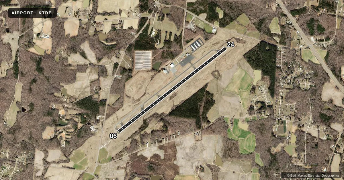
Airport sketch
Runways drawn to scale from FAA survey coordinates, rendered over satellite imagery. Not for navigation.
Approaches & charts
ILS · 1
Services on the field
Fuel grades, oxygen, maintenance, ramp storage and lighting — as declared to the FAA by the airport operator.
Fuel & services
- Fuel
- 100LLA1+
- Other services
- CARGO,INSTR,RNTL
Ramp & ground
- Transient storage
- Tie-down
- Lighting schedule
- SEE RMK
- Beacon schedule
- SS-SR
- Beacon
- White / Green (civil land)(WG)
- Wind indicator
- Lighted
- Segmented circle
- Yes
Fuel & FBOs
Cheapest 100LL and Jet A on the field and nearby. Always confirm with the FBO before taxi.
Airport notes
Surface conditions, obstructions, local procedures, lighting outages and other notes published with each FAA cycle.
General notes
- DEER & BIRDS ON & INVOF ARPT.
- GCO AVBL ON FREQ 119.700 THRU RALEIGH APCH.
- CONC HELIPAD, ADJ AND NE OF MAIN APRON, UNLGTD, VFR ONLY.
- NO LINE OF SIGHT BTN RWY ENDS.
- FOR CD IF UNA VIA GCO CTC RALEIGH APCH AT 919-380-3144.
Lighting notes
- REIL RWY 24; MIRL RWY 06/24 OPR SS-SR; TO ACTVT OTR TIMES AND ACTVT MALSR RWY 06; PAPI RWY 06 & 24 - CTAF.
Other notes
- 1ARPT UNATNDD THANKSGIVING & CHRISTMAS.
- 1FOR SVC AFT HRS CALL 615-351-9845.
- MANAGERFAX: 336-364-2224.
VFR map & nearby airports
VFR sectional. Tap any ICAO chip to open that airport.
Key facts · KTDF
Answer card- ICAO
- KTDF
- Name
- RALEIGH RGNL AT PERSON COUNTY
- Location
- ROXBORO, NORTH CAROLINA
- Elevation
- 608.9 ft MSL
- Traffic pattern altitude
- 1,608.9 ft MSL (1,000 AGL)
- Control tower
- Non-towered (use CTAF)
- Total runways
- 1
- Longest runway
- 06/24 · 6,005 ft
- Published ILS approaches
- 1
- Published frequencies
- 4
- Magnetic variation
- 8°
- Current flight rules
- VFR
- Current wind
- 360° at 5 kt
- Favored runway now
- RWY 06
KTDF is in Roxboro, North Carolina. Field elevation is 608.9 ft MSL. The airport has one runway, 06/24 and it is 6,005 ft long. There is no control tower. The published pattern altitude is not listed, so use the standard 1,000 ft AGL pattern unless the current Chart Supplement says otherwise.
Runway 06 has an ILS approach. The published remarks also note PAPI on both runway ends. Runway lights on 06 and 24 operate from sunset to sunrise. They can be activated at other times by using CTAF. The airport also has runway end identifier lights on runway 24. There is no line of sight between runway ends. Plan your ground calls with that in mind.
Red Mountain Aviation is on the field. It carries AVGAS 100LL and Jet A. The airport is unattended on Thanksgiving and Christmas. Deer and birds are reported on and near the field. Keep a sharp scan on arrival and departure. There is also a concrete helipad northeast of the main apron. It is unlighted and for VFR use only.
For first-time pilots, the main things to watch are the non-towered traffic flow, wildlife and the published lighting procedures. If you need current operational details, check the current FAA Chart Supplement or call the airport operator or the FBO directly by phone.