METAR & TAF KHNZ
Current METAR
Observed 14:55Z
KHNZ 271455Z AUTO 35004KT 10SM SCT015 SCT021 25/21 A2989 RMK AO2 T02460205
- Wind
- 350° @ 4 kt
- Visibility
- 10 SM
- Temp / Dew
- 25°C / 21°C
- Altimeter
- 29.89 inHg
- Clouds
- SCT
- Density alt
- 1,890 ft
- Ceiling
- Unlimited
- Rules
- VFR
Airport info & contacts
Manager on record, flight service, ARTCC, attendance schedule and pattern altitude — published by the FAA and refreshed every 28 days.
Location
- From city
- 4 NM NE
- VFR sectional
- WASHINGTON
- ARTCC
- ZDC · WASHINGTON
- NOTAM facility
- HNZ (NOTAM-D)
Airport manager
- Name
- AMANDA WELSH
- Phone
- 919-693-5769
- Address
- 6514 AIRPORT ROAD, OXFORD NC 27565-6459
Flight service · Hours
- FSS RDU
- RALEIGH1-800-WX-BRIEF
- Attendance
- MON-SAT · 0800-1700
- SUN · 1300-1700
Frequencies
Tap any row to copy the frequency to your clipboard.
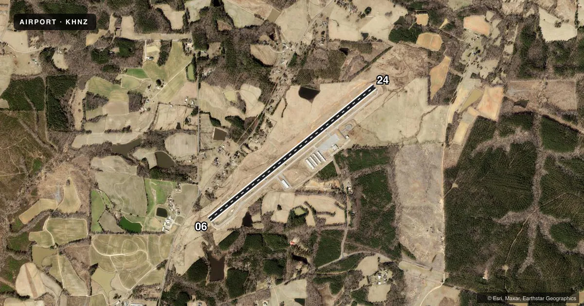
Runways & pattern
Full pagePattern entry · RWY 06
LEFT TRAFFICRunway end performance
| End | TORA | TODA | ASDA | LDA | VGSI | Approach lights | Obstruction |
|---|---|---|---|---|---|---|---|
| 06 | — | — | — | — | PAPI 4-box left(3.25°) | — | 48', trees, 1634' from thr, 63' R of cntrln, slope 29 |
| 24 | — | — | — | — | PAPI 4-box right(3°) | — | 33', pline, 1353' from thr, 0' R of cntrln, slope 34 |
Declared distances in feet. TORA = takeoff run available, TODA = takeoff distance, ASDA = accelerate-stop, LDA = landing distance.
Airport sketch
Runways drawn to scale from FAA survey coordinates, rendered over satellite imagery. Not for navigation.
Approaches & charts
ILS · 1
Services on the field
Fuel grades, oxygen, maintenance, ramp storage and lighting — as declared to the FAA by the airport operator.
Fuel & services
- Fuel
- 100LLA1+
- Oxygen (bottled)
- Not available
- Oxygen (bulk)
- Not available
- Airframe repair
- Major
- Power plant repair
- Major
- Other services
- INSTR,RNTL
Ramp & ground
- Transient storage
- Tie-down
- Landing fee
- No fee published
- Customs
- Not available
- Lighting schedule
- SEE RMK
- Beacon schedule
- SS-SR
- Beacon
- White / Green (civil land)(WG)
- Wind indicator
- Lighted
- Segmented circle
- Yes
Fuel & FBOs
Cheapest 100LL and Jet A on the field and nearby. Always confirm with the FBO before taxi.
Airport notes
Surface conditions, obstructions, local procedures, lighting outages and other notes published with each FAA cycle.
General notes
- RWY 24 HAS 60 FT DROP OFF 325 FT FM THR & 90 FT LEFT & RIGHT FM CNTRLN.
- FOR AFTER HOURS SERVICE CALL 919-693-5769.
- TREES EAST OF THE ARPT OBSCURE THE ROTG BCN.
- HOLD LINES ARE LESS THAN 150 FT FROM CNTRLN.
- RWY 24 HAS 30 FT UNMKD POWERLINE 1000 FT FM THR ON CNTRLN.
- FOR CD IF UNA VIA GCO CTC RALEIGH APCH AT 919-380-3144.
- RWY 6 HAS 30 FT DROP-OFF 280 FT FROM THR & 40-60 FT DROP-OFF 75 FT BOTH SIDES OF CNTRLN.
- RWY 6 HAS 28 FT UNMARKED POWERLINE 1000 FT FM THR ON CNTRLN.
- NO LINE OF SIGHT BTN RWY ENDS.
Lighting notes
- ACTVT REIL RWY 06; MIRL RWY 06/24 - CTAF. PAPI RWY 06 & 24 OPR CONSLY.
Fuel notes
- 100LLFUEL 24 HR CREDIT CARD SVC AVBL.
Other notes
- AND CITY OF HENDERSON.
- AND VANCE CO.
- 1UNATTENDED THANKSGIVING & CHRISTMAS DAYS.
VFR map & nearby airports
VFR sectional. Tap any ICAO chip to open that airport.
Key facts · KHNZ
Answer card- ICAO
- KHNZ
- Name
- HENDERSON/OXFORD
- Location
- OXFORD, NORTH CAROLINA
- Elevation
- 526.3 ft MSL
- Traffic pattern altitude
- 1,526.3 ft MSL (1,000 AGL)
- Control tower
- Non-towered (use CTAF)
- Total runways
- 1
- Longest runway
- 06/24 · 5,501 ft
- Published ILS approaches
- 1
- Published frequencies
- 4
- Magnetic variation
- 9°
- Current flight rules
- VFR
- Current wind
- 350° at 4 kt
- Favored runway now
- RWY 06
Henderson/Oxford is in Oxford, North Carolina, in Vance County. The field elevation is 526.3 ft MSL. It has one runway, 06/24, which is 5,501 ft long and paved with asphalt. There is no control tower. CTAF and UNICOM are both 122.8. Raleigh Approach handles approach and departure work on 132.35 and 256.9.
The airport has one ILS approach, published for runway 06. Pattern altitude is not published, so use the standard 1,000 ft AGL for light piston traffic unless the current FAA Chart Supplement says otherwise. The runway ends do not have line of sight to each other, so keep that in mind on the CTAF. Runway 6 has a drop-off near the threshold and a powerline on the centerline about 1,000 ft out. Runway 24 also has a drop-off near the threshold. Trees east of the airport can hide the rotating beacon.
flyHNZ is on the field. It carries 100LL and Jet A. Fuel has 24-hour credit card service. For after-hours service, call the FBO directly. The airport is unattended on Thanksgiving and Christmas days. The runway lights are CTAF-controlled. PAPI on both runway ends operates continuously.