METAR & TAF W63
Current METAR
Observed 13:35Z
KW63 271335Z AUTO 01003KT 10SM SCT012 25/22 A2988 RMK AO1
- Wind
- 010° @ 3 kt
- Visibility
- 10 SM
- Temp / Dew
- 25°C / 22°C
- Altimeter
- 29.88 inHg
- Clouds
- SCT
- Density alt
- 1,772 ft
- Ceiling
- Unlimited
- Rules
- VFR
Airport info & contacts
Manager on record, flight service, ARTCC, attendance schedule and pattern altitude — published by the FAA and refreshed every 28 days.
Location
- From city
- 2 NM S
- VFR sectional
- WASHINGTON
- Pattern altitude
- 800 ft AGL · 1,221 ft MSL
- ARTCC
- ZDC · WASHINGTON
- NOTAM facility
- DCA (NOTAM-D)
Airport manager
- Name
- MICHAEL DENTON
- Phone
- 434-374-8028
- Address
- LAKE COUNTRY REGIONAL AIRPORT, 11632 HWY 15, CLARKSVILLE VA 23927
Flight service · Hours
- FSS DCA
- LEESBURG1-800-WX-BRIEF
- Attendance
- 0800-1700
Frequencies
Tap any row to copy the frequency to your clipboard.
Runways & pattern
Full pagePattern entry · RWY 04
LEFT TRAFFICRunway end performance
| End | TORA | TODA | ASDA | LDA | VGSI | Approach lights | Obstruction |
|---|---|---|---|---|---|---|---|
| 04 | — | — | — | — | — | — | 29', tree, 416' from thr, 279' R of cntrln, slope 7 |
| 22 | — | — | — | — | — | — | 18', road, 200' from thr, 0' R of cntrln, slope 1 |
Declared distances in feet. TORA = takeoff run available, TODA = takeoff distance, ASDA = accelerate-stop, LDA = landing distance.
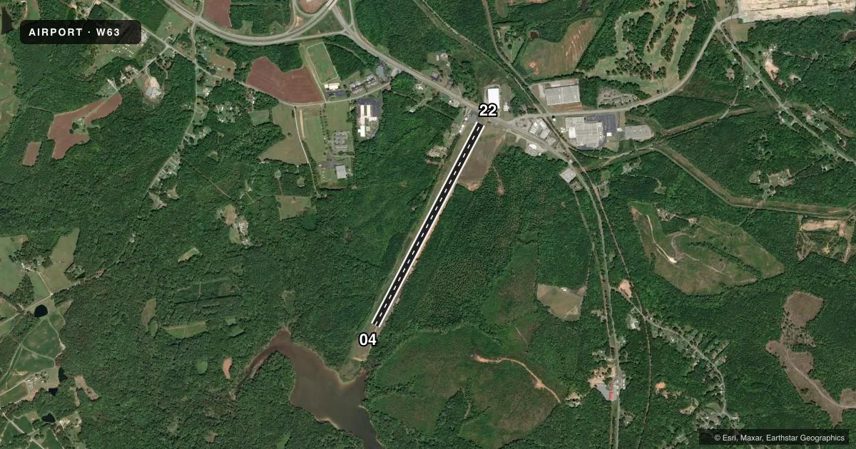
Airport sketch
Runways drawn to scale from FAA survey coordinates, rendered over satellite imagery. Not for navigation.
Approaches & charts
Services on the field
Fuel grades, oxygen, maintenance, ramp storage and lighting — as declared to the FAA by the airport operator.
Fuel & services
- Fuel
- 100LL
- Oxygen (bottled)
- Not available
- Oxygen (bulk)
- Not available
- Airframe repair
- Not available
- Power plant repair
- Not available
Ramp & ground
- Transient storage
- Tie-down
- Landing fee
- No fee published
- Customs
- Not available
- Lighting schedule
- SS-SR
- Beacon schedule
- SS-SR
- Beacon
- White / Green (civil land)(WG)
- Wind indicator
- Yes
- Segmented circle
- No
Fuel & FBOs
Cheapest 100LL and Jet A on the field and nearby. Always confirm with the FBO before taxi.
Airport notes
Surface conditions, obstructions, local procedures, lighting outages and other notes published with each FAA cycle.
General notes
- WILDLIFE INVOF ARPT.
- SELF SVC FUEL AVBL.
- FOR CD CTC WASHINGTON ARTCC AT 703-771-3587.
Approach & departure obstructions
- 04CLOSE-IN OBSTN, 27 FT ABV RWY SFC, ROW OF TREES 179 FT RIGHT OF CNTRLN ON APCH.
- 22ROAD CROSSING 170 FT FROM END OF RWY. BUILDING 27 FT, 90 FT FROM END OF RWY, 110 FT L.
- 22RYW 22 APCH SLOPE 15:1 TO DSPLCD THR FROM 82 FT TREE 1502 FT FR DSPLCD THR, 142 FT L.
VFR map & nearby airports
VFR sectional. Tap any ICAO chip to open that airport.
Key facts · W63
Answer card- ICAO
- W63
- Name
- LAKE COUNTRY RGNL
- Location
- CLARKSVILLE, VIRGINIA
- Elevation
- 420.9 ft MSL
- Traffic pattern altitude
- 1,220.9 ft MSL (800 AGL)
- Control tower
- Non-towered (use CTAF)
- Total runways
- 1
- Longest runway
- 04/22 · 4,007 ft
- Published ILS approaches
- 0
- Published frequencies
- 1
- Magnetic variation
- 8°
- Current flight rules
- VFR
- Current wind
- 010° at 3 kt
- Favored runway now
- RWY 04
Lake Country Rgnl (W63) sits in Clarksville, Virginia. Field elevation is 420.9 ft MSL. The airport has one runway, 04/22, which is 4,007 ft long. It is a non-towered field, so use CTAF 122.9 and keep your calls tight in the pattern.
Pattern altitude is 800 ft AGL, which is 1,220.9 ft MSL. No ILS approaches are published here, so plan with the current Chart Supplement and your normal VFR or non-ILS IFR backup. The published remarks also matter. Runway 04 has a close-in tree obstruction on the approach side. Runway 22 has a road near the departure end. There is also a building near the threshold area. Wildlife is also reported in the vicinity, so expect extra scanning on taxi, takeoff and landing.
Self-service fuel is available on the field. No on-field FBOs are listed in the facts, so verify current services with the airport operator or by calling the field before arrival. For clearance delivery, contact Washington ARTCC at 703-771-3587. The runway headings are 28° and 208° magnetic, with 8° magnetic variation. This is a small, non-towered airport with published obstructions, so a first-time pilot should brief the approach carefully and expect local traffic to be using the common traffic advisory frequency.