METAR & TAF KDAN
Current METAR
Observed 10:00Z
KDAN 271000Z AUTO 00000KT 1/4SM FG VV001 21/20 A2986 RMK AO2 T02060200 $
- Wind
- 000° @ 0 kt
- Visibility
- 0.25 SM
- Temp / Dew
- 21°C / 20°C
- Altimeter
- 29.86 inHg
- Clouds
- VV
- Density alt
- 1,503 ft
- Ceiling
- 100 ft AGL
- Rules
- LIFR
Airport info & contacts
Manager on record, flight service, ARTCC, attendance schedule and pattern altitude — published by the FAA and refreshed every 28 days.
Location
- From city
- 3 NM E
- VFR sectional
- CINCINNATI
- ARTCC
- ZDC · WASHINGTON
- NOTAM facility
- DAN (NOTAM-D)
Airport manager
- Name
- MARC ADELMAN
- Phone
- 434-799-5110
- Address
- 424 AIRPORT DRIVE, DANVILLE VA 24540
Flight service · Hours
- FSS DCA
- LEESBURG1-800-WX-BRIEF
- Attendance
- MON-FRI · 0700-1900
- SAT-SUN · 0700-1900
Frequencies
Tap any row to copy the frequency to your clipboard.
Runways & pattern
Full pagePattern entry · RWY 02
LEFT TRAFFIC| Runway | Heading (°M) | Length | Surface | Traffic |
|---|---|---|---|---|
| 02/20 | 7° / 187° | 5,900 ft | ASPH | Standard L |
| 13/31 | 116° / 296° | 3,910 ft | ASPH | Standard L |
Runway end performance
| End | TORA | TODA | ASDA | LDA | VGSI | Approach lights | Obstruction |
|---|---|---|---|---|---|---|---|
| 02 | 5,600' | 5,900' | 5,600' | 5,600' | PAPI 4-box left(3°) | MALSR | 53', tree, 2255' from thr, 750' R of cntrln, slope 38 |
| 20 | 5,900' | 5,900' | 5,900' | 5,600' | PAPI 4-box left(3°) | — | 129', tree, 4436' from thr, 552' R of cntrln, slope 32 |
| 13 | — | — | — | — | VASI 2-box left(3°) | — | 120', tree, 2708' from thr, 429' R of cntrln, slope 20 |
| 31 | — | — | — | — | PAPI 2-box left(4°) | — | 19', trees, 464' from thr, 61' R of cntrln, slope 13 |
Declared distances in feet. TORA = takeoff run available, TODA = takeoff distance, ASDA = accelerate-stop, LDA = landing distance.
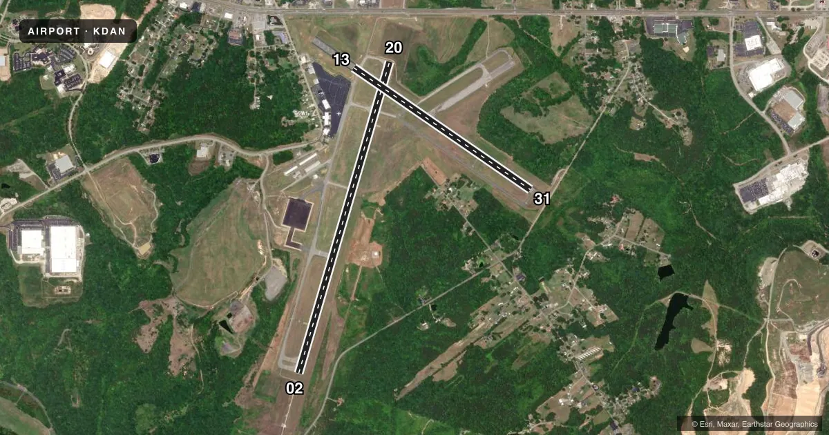
Airport sketch
Runways drawn to scale from FAA survey coordinates, rendered over satellite imagery. Not for navigation.
Approaches & charts
ILS · 1
Services on the field
Fuel grades, oxygen, maintenance, ramp storage and lighting — as declared to the FAA by the airport operator.
Fuel & services
- Fuel
- 100LLA+
- Oxygen (bottled)
- Not available
- Oxygen (bulk)
- Not available
- Airframe repair
- Major
- Power plant repair
- Major
- Other services
- INSTR,RNTL
Ramp & ground
- Transient storage
- Tie-down
- Hangar
- Landing fee
- No fee published
- Customs
- Not available
- Lighting schedule
- SEE RMK
- Beacon schedule
- SS-SR
- Beacon
- White / Green (civil land)(WG)
- Wind indicator
- Lighted
- Segmented circle
- Yes
Fuel & FBOs
Cheapest 100LL and Jet A on the field and nearby. Always confirm with the FBO before taxi.
Airport notes
Surface conditions, obstructions, local procedures, lighting outages and other notes published with each FAA cycle.
General notes
- BIRDS & DEER ON & INVOF ARPT.
- RY 02 IS DESIGNATED CALM WIND RY.
- CTC ARPT ADMIN PRIOR TO CONDUCTING SPECIALIZED AERO ACTIVITIES 434-799-5110.
- TREES PENETRATING 7:1 TRANSITIONAL SURFACE, RY 31 BOTH SIDES, FIRST 1000 FT.
- FOR CD IF UNA TO CTC ON FSS FREQ, CTC WASHINGTON ARTCC AT 703-771-3587.
Lighting notes
- ACTVT HIRL RY 02/20, MIRL RY 13/31, REIL RYS 13, 31, & 20, MALSR RY 02, VASI RY 13, & PAPIS RYS 02, 20, & 31 - CTAF.
Approach & departure obstructions
- 20SLP TO DTHR 39:1.
Other notes
- VFR DAYLIGHT USE ONLY; COORDINATION WITH DANVILLE MUNI ARPT; FOLLOW-ON FAA INSPECTION.
- TPA 800 FT AGL LGT ACFT; 1500 FT AGL TURBINE ACFT.
- 1ARPT UNATTND CHRISTMAS DAY
VFR map & nearby airports
VFR sectional. Tap any ICAO chip to open that airport.
Key facts · KDAN
Answer card- ICAO
- KDAN
- Name
- DANVILLE RGNL
- Location
- DANVILLE, VIRGINIA
- Elevation
- 571.1 ft MSL
- Traffic pattern altitude
- 1,571.1 ft MSL (1,000 AGL)
- Control tower
- Non-towered (use CTAF)
- Total runways
- 2
- Longest runway
- 02/20 · 5,900 ft
- Published ILS approaches
- 1
- Published frequencies
- 2
- Magnetic variation
- 9°
- Current flight rules
- LIFR
- Current wind
- 000° at 0 kt
- Favored runway now
- –
Danville Rgnl sits in Danville, Virginia at 571.1 ft MSL. It has two asphalt runways. The longest is 5,900 ft. There is no control tower. CTAF and UNICOM are both 123.05. One ILS approach is published for runway 02. Published pattern altitude is 800 ft AGL for light aircraft. Turbine traffic uses 1,500 ft AGL.
AU Aviation Services is on the field. It carries 100LL and Jet A. Call (434) 791-5750 for current service details before you go. The airport remarks matter here. Birds and deer are present on and near the field. Runway 02 is the calm wind runway. The airport is listed for VFR daylight use only. Coordination with Danville Municipal Airport is required. A follow-on FAA inspection is pending.
Runway 02/20 is 5,900 ft. Runway 13/31 is 3,910 ft. Runway lighting is available on both runways. Approach lighting and PAPI are published on multiple ends. Trees penetrate the transitional surface near runway 31 for the first 1,000 ft. That makes a careful look at departure and arrival profiles smart, especially if you are new to the airport. Check the current FAA Chart Supplement before flying in. That is the best source for any updated operating limits or local procedures.