METAR & TAF KSIF
Current METAR
Observed 12:35Z
KSIF 271235Z AUTO 00000KT 4SM BR SCT060 SCT070 22/22 A2991 RMK AO2 T02190217
- Wind
- 000° @ 0 kt
- Visibility
- 4 SM
- Temp / Dew
- 22°C / 22°C
- Altimeter
- 29.91 inHg
- Clouds
- SCT
- Density alt
- 1,712 ft
- Ceiling
- Unlimited
- Rules
- MVFR
Airport info & contacts
Manager on record, flight service, ARTCC, attendance schedule and pattern altitude — published by the FAA and refreshed every 28 days.
Location
- From city
- 8 NM NW
- VFR sectional
- CINCINNATI
- ARTCC
- ZTL · ATLANTA
- NOTAM facility
- SIF (NOTAM-D)
Airport manager
- Name
- MIKE BROOKS
- Phone
- 336-573-3115
- Address
- 2691 SETTLE BRIDGE ROAD, STONEVILLE NC 27048
Flight service · Hours
- FSS RDU
- RALEIGH1-800-WX-BRIEF
- Attendance
- 0800-1700
Frequencies
Tap any row to copy the frequency to your clipboard.
Runways & pattern
Full pagePattern entry · RWY 13
LEFT TRAFFICRunway end performance
| End | TORA | TODA | ASDA | LDA | VGSI | Approach lights | Obstruction |
|---|---|---|---|---|---|---|---|
| 13 | — | — | — | — | PAPI 4-box left(3.7°) | — | 71', trees, 646' from thr, 298' R of cntrln, slope 6 |
| 31 | — | — | — | — | PAPI 4-box left(3.7°) | — | 41', trees, 771' from thr, 299' R of cntrln, slope 13 |
Declared distances in feet. TORA = takeoff run available, TODA = takeoff distance, ASDA = accelerate-stop, LDA = landing distance.
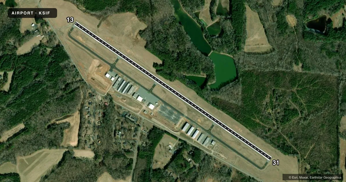
Airport sketch
Runways drawn to scale from FAA survey coordinates, rendered over satellite imagery. Not for navigation.
Approaches & charts
ILS · 1
Services on the field
Fuel grades, oxygen, maintenance, ramp storage and lighting — as declared to the FAA by the airport operator.
Fuel & services
- Fuel
- 100LLA1+
- Oxygen (bottled)
- Not available
- Oxygen (bulk)
- Not available
- Airframe repair
- Major
- Power plant repair
- Major
- Other services
- INSTR
Ramp & ground
- Transient storage
- Tie-down
- Landing fee
- No fee published
- Lighting schedule
- SEE RMK
- Beacon schedule
- SS-SR
- Beacon
- White / Green (civil land)(WG)
- Wind indicator
- Lighted
- Segmented circle
- Yes
Fuel & FBOs
Cheapest 100LL and Jet A on the field and nearby. Always confirm with the FBO before taxi.
Airport notes
Surface conditions, obstructions, local procedures, lighting outages and other notes published with each FAA cycle.
General notes
- DEER ON & INVOF ARPT.
- FOR CD CTC GREENSBORO APCH AT 743-222-6129.
- SEASONAL FARMING OPNS AND EQPT INVOF RWY.
Lighting notes
- ACTVT REIL RWY 13 & 31; PAPI RWY 13 & 31; HIRL RWY 13/31 - CTAF.
Fuel notes
- 100LL100LL FUEL 24 HR CREDIT CARD SVC AVBL.
Approach & departure obstructions
- 135 FT GND 0-200 FT FROM THR 150 FT RIGHT OF CNTRLN.
- 13APCH RATIO 11:1 AT DSPLCD THR; DUE TO 80 FT TREES 1149 FT FROM DSPLCD THR 261 FT RIGHT OF CNTRLN.
Other notes
- MANAGERMANAGER CELL 336-613-7671.
- MANAGERFAX 336-573-9415.
VFR map & nearby airports
VFR sectional. Tap any ICAO chip to open that airport.
Key facts · KSIF
Answer card- ICAO
- KSIF
- Name
- ROCKINGHAM COUNTY NC SHILOH
- Location
- REIDSVILLE, NORTH CAROLINA
- Elevation
- 693.5 ft MSL
- Traffic pattern altitude
- 1,693.5 ft MSL (1,000 AGL)
- Control tower
- Non-towered (use CTAF)
- Total runways
- 1
- Longest runway
- 13/31 · 5,200 ft
- Published ILS approaches
- 1
- Published frequencies
- 4
- Magnetic variation
- 7°
- Current flight rules
- MVFR
- Current wind
- 000° at 0 kt
- Favored runway now
- –
Rockingham County NC Shiloh is in Reidsville, North Carolina. Field elevation is 693.5 ft MSL. The airport has one runway, 13/31, which is 5,200 ft long. There is no control tower. The pattern altitude is not published, so use the standard 1,000 ft AGL for light piston traffic unless the current Chart Supplement says otherwise.
Runway 31 has an ILS approach. Runway 13 and 31 have runway end identifier lights and PAPI. The runway also has high intensity lighting. Use CTAF for lighting control. The field sits in a rural area with deer on and near the airport. Seasonal farming equipment is also in the vicinity, so keep a sharp scan on taxi and final.
Rockingham County Airport is on the field. It carries 100LL and Jet A Prist. 100LL is available 24 hours with credit card service. For clearance delivery, contact Greensboro Approach. The published remarks also note an approach limitation on runway 13 because of trees near the displaced threshold. There is also a small ground obstruction near the threshold on runway 13. First-time arrivals should brief the runway 13 environment carefully and check the current FAA Chart Supplement before departure.