METAR & TAF N63
N63 does not publish a METAR.
Showing the nearest reporting station: KINT (SMITH REYNOLDS) · 10.7 NM away. Conditions at N63 may differ.
METAR · KINT
Observed 01:54Z
KINT 270154Z AUTO 19003KT 10SM FEW046 26/22 A2991 RMK AO2 SLP118 T02560217
- Wind
- 190° @ 3 kt
- Visibility
- 10 SM
- Temp / Dew
- 26°C / 22°C
- Altimeter
- 29.91 inHg
- Clouds
- FEW
- Density alt
- 2,135 ft
- Ceiling
- Unlimited
- Rules
- VFR
Airport info & contacts
Manager on record, flight service, ARTCC, attendance schedule and pattern altitude — published by the FAA and refreshed every 28 days.
Location
- From city
- 1 NM NW
- VFR sectional
- CINCINNATI
- ARTCC
- ZTL · ATLANTA
- NOTAM facility
- RDU (NOTAM-D)
Airport manager
- Name
- LOGAN FULP
- Phone
- 336-413-3967
- Address
- 1060 AIRPORT ROAD, WALNUT COVE NC 27052
Flight service · Hours
- FSS RDU
- RALEIGH1-800-WX-BRIEF
- Attendance
- IRREGULAR
Frequencies
Tap any row to copy the frequency to your clipboard.
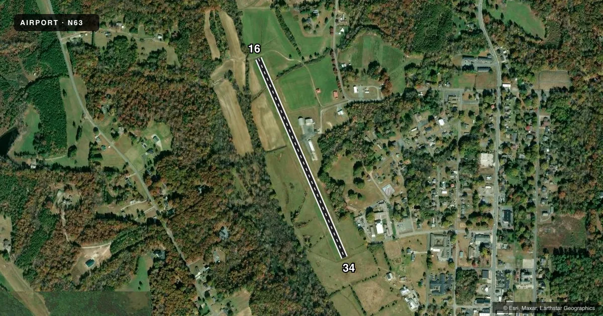
Runways & pattern
Full pagePattern entry · RWY 16
LEFT TRAFFICRunway end performance
| End | TORA | TODA | ASDA | LDA | VGSI | Approach lights | Obstruction |
|---|---|---|---|---|---|---|---|
| 16 | — | — | — | — | — | — | 39', trees, 331' from thr, 91' R of cntrln, slope 3 |
| 34 | — | — | — | — | — | — | 31', trees, 372' from thr, 164' R of cntrln, slope 5 |
Declared distances in feet. TORA = takeoff run available, TODA = takeoff distance, ASDA = accelerate-stop, LDA = landing distance.
Airport sketch
Runways drawn to scale from FAA survey coordinates, rendered over satellite imagery. Not for navigation.
Approaches & charts
Services on the field
Fuel grades, oxygen, maintenance, ramp storage and lighting — as declared to the FAA by the airport operator.
Fuel & services
- Fuel
- 100LL
- Airframe repair
- Not available
- Power plant repair
- Not available
Ramp & ground
- Transient storage
- Not published
- Landing fee
- No fee published
- Customs
- Not available
- Lighting schedule
- SEE RMK
- Wind indicator
- Yes
- Segmented circle
- No
Fuel & FBOs
Cheapest 100LL and Jet A on the field and nearby. Always confirm with the FBO before taxi.
Airport notes
Surface conditions, obstructions, local procedures, lighting outages and other notes published with each FAA cycle.
General notes
- HIGH TRRN IN ALL QUADS.
- +65 FT TREES WITHIN 110 FT OF CNTRLN EAST OF RWY.
- FENCING IN THE CLEAR ZONE RWYS 16 & 34.
- +8 FT DROP-OFF AREA RWY 16.
- ARPT CLSD TO TSNTS EXCP PPR CALL 336-403-1796.
- DO NOT LAND ON GRASS ADJ TO RWY. DEEP DITCHES.
- FOR CD CTC GREENSBORO APCH AT 336-333-5119.
- NO HEAVY TRNG TFC NO MORE THAN TWO TOUCH AND GOES AT ONE GIVEN TIME.
- NO TSNT TFC BEFORE DALGT OR AFT DARK.
Lighting notes
- ACTVT LIRL RWY 16/34 - CTAF.
Fuel notes
- 100LL100LL SELF SVC AVBL BY FBO.
Runway surface & condition
- 16/34NSTD LIRL; LGTS 30 FT EITHER SIDE OF ASPH ALONG OLD TURF RWY. NSTD THR LGTS WITH GREEN, RED, CLEAR AND BI-DIRECTIONAL LENS.
Approach & departure obstructions
- 16SCRUB TREES RANGING FROM 22 FT - 41 FT LCTD 0-200 FT FM THR OFFSET 100 FT RIGHT OF CNTRLN.
- 34+3 FT FENCE 30 FT FM THR BOTH SIDES OF CNTRLN.
- 16MKGS FADED AND OBSCURED BY RWY SEALANT.
- 34MKGS FADED AND OBSCURED BY RWY SEALANT.
- 16RWY MKNG SMALLER THAN NORMAL AND FADED.
- 34RWY MKNG SMALLER THAN NORMAL AND FADED; CNTRLN NSTD.
Other notes
- VFR USE ONLY.
VFR map & nearby airports
VFR sectional. Tap any ICAO chip to open that airport.
Key facts · N63
Answer card- ICAO
- N63
- Name
- MEADOW BROOK FLD
- Location
- WALNUT COVE, NORTH CAROLINA
- Elevation
- 647 ft MSL
- Traffic pattern altitude
- 1,647 ft MSL (1,000 AGL)
- Control tower
- Non-towered (use CTAF)
- Total runways
- 1
- Longest runway
- 16/34 · 2,725 ft
- Published ILS approaches
- 0
- Published frequencies
- 4
- Magnetic variation
- 6°
- Current flight rules
- VFR
- Current wind
- 190° at 3 kt
- Favored runway now
- RWY 16
Meadow Brook Fld is in Walnut Cove, North Carolina. The field elevation is 647 ft MSL. It has one runway. The longest is 2,725 ft of asphalt on 16/34. There is no control tower. No ILS approaches are published, so plan for VFR only and check the current FAA Chart Supplement before you go.
The pattern altitude is not published. Use 1,000 ft AGL for light piston operations unless the current Chart Supplement says otherwise. The airport is closed to transient aircraft except by prior permission required. Call 336-403-1796 before arrival. It is also for visual flight rules use only. Greensboro Approach handles clearance delivery at 336-333-5119.
The published remarks matter here. There is an 8 ft drop-off area on runway 16. Trees over 65 ft tall sit within 110 ft of the centerline east of the runway. Scrub trees are also reported near the threshold on runway 16. Runway 16 markings are faded and obscured by runway sealant. Low intensity runway lights on 16/34 are activated by the CTAF. 100LL self-serve fuel is available from the fixed base operator. No on-field FBO names are listed in the facts. No heavy training traffic is permitted. No more than two touch-and-go landings are allowed at one time. No transient traffic is permitted before daylight or after dark.