METAR & TAF KMWK
Current METAR
Observed 11:35Z
KMWK 271135Z AUTO 03002KT 10SM CLR 21/20 A2994 RMK AO2
- Wind
- 030° @ 2 kt
- Visibility
- 10 SM
- Temp / Dew
- 21°C / 20°C
- Altimeter
- 29.94 inHg
- Clouds
- CLR
- Density alt
- 2,269 ft
- Ceiling
- Unlimited
- Rules
- VFR
Airport info & contacts
Manager on record, flight service, ARTCC, attendance schedule and pattern altitude — published by the FAA and refreshed every 28 days.
Location
- From city
- 3 NM SE
- VFR sectional
- CINCINNATI
- ARTCC
- ZTL · ATLANTA
- NOTAM facility
- MWK (NOTAM-D)
Airport manager
- Name
- GEORGE CRATER
- Phone
- 336-789-5153
- Address
- 146 HOWARD WOLTZ JR. WAY, MOUNT AIRY NC 27030-9020
Flight service · Hours
- FSS RDU
- RALEIGH1-800-WX-BRIEF
- Attendance
- Continuous
Frequencies
Tap any row to copy the frequency to your clipboard.
Runways & pattern
Full pagePattern entry · RWY 36
LEFT TRAFFICRunway end performance
| End | TORA | TODA | ASDA | LDA | VGSI | Approach lights | Obstruction |
|---|---|---|---|---|---|---|---|
| 18 | — | — | — | — | PAPI 4-box right(3°) | — | 47', trees, 1219' from thr, 275' R of cntrln, slope 21 |
| 36 | — | — | — | — | PAPI 4-box left(3°) | — | 63', other, 1842' from thr, 32' R of cntrln, slope 26 |
Declared distances in feet. TORA = takeoff run available, TODA = takeoff distance, ASDA = accelerate-stop, LDA = landing distance.
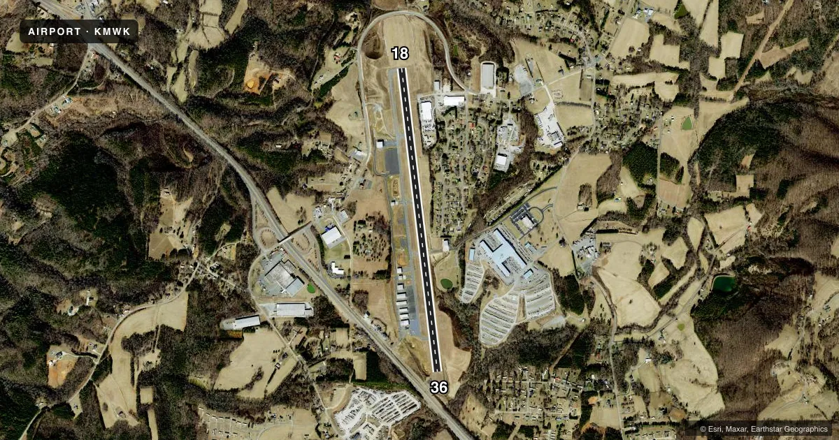
Airport sketch
Runways drawn to scale from FAA survey coordinates, rendered over satellite imagery. Not for navigation.
Approaches & charts
Services on the field
Fuel grades, oxygen, maintenance, ramp storage and lighting — as declared to the FAA by the airport operator.
Fuel & services
- Fuel
- 100LLAA1+
- Oxygen (bottled)
- Not available
- Oxygen (bulk)
- Not available
- Airframe repair
- Major
- Power plant repair
- Major
- Other services
- INSTR,RNTL
Ramp & ground
- Transient storage
- Tie-down
- Hangar
- Landing fee
- No fee published
- Customs
- Not available
- Lighting schedule
- SEE RMK
- Beacon schedule
- SS-SR
- Beacon
- White / Green (civil land)(WG)
- Wind indicator
- Lighted
- Segmented circle
- Yes
Fuel & FBOs
Cheapest 100LL and Jet A on the field and nearby. Always confirm with the FBO before taxi.
Airport notes
Surface conditions, obstructions, local procedures, lighting outages and other notes published with each FAA cycle.
General notes
- RWY 36 SLOPES UPHILL 34 FEET.
- AFTER HOURS SERVICE AVAILABLE/POSTED ON PHONE BOX.
- RWY 36 - 50 FT DROP-OFF 300 FT FM THR AND 150 FT RIGHT & LEFT OF CNTRLN.
- FOR CD CTC GREENSBORO APCH AT 743-222-6129.
- RWY HAS 100 FT DROP-OFFS 90 FT FM CNTRLN BOTH SIDES AND 300 FT FM THR.
Lighting notes
- ACTVT REIL RWY 18 & 36; PAPI RWY 18 & 36; MIRL RWY 18/36 - CTAF.
Other notes
- 10800- (EARLIER OF) 1800 LOCAL OR SS.
VFR map & nearby airports
VFR sectional. Tap any ICAO chip to open that airport.
Key facts · KMWK
Answer card- ICAO
- KMWK
- Name
- MOUNT AIRY/SURRY COUNTY
- Location
- MOUNT AIRY, NORTH CAROLINA
- Elevation
- 1,268.9 ft MSL
- Traffic pattern altitude
- 2,268.9 ft MSL (1,000 AGL)
- Control tower
- Non-towered (use CTAF)
- Total runways
- 1
- Longest runway
- 18/36 · 5,500 ft
- Published ILS approaches
- 0
- Published frequencies
- 4
- Magnetic variation
- 7°
- Current flight rules
- VFR
- Current wind
- 030° at 2 kt
- Favored runway now
- RWY 36
Mount Airy/Surry County Airport sits in Mount Airy, North Carolina. Field elevation is 1,268.9 ft MSL. The airport has one runway. Runway 18/36 is 5,500 ft long, so it gives light aircraft a solid margin, though the published remarks call out steep drop-offs near the runway edges and near the thresholds. Runway 36 also slopes uphill 34 ft, so plan for that on landing and departure.
This is a non-towered field. Airport attendance is from 0800 until the earlier of 1800 local or sunset. After-hours service is available and posted on the phone box. No ILS approaches are published, so check the current FAA Chart Supplement for the latest approach and procedure details before you go. Pattern altitude is not published. Use the standard 1,000 ft AGL pattern unless local procedures or current chart data say otherwise.
The on-field FBO is Mount Airy/Surry County Airport. It carries 100LL and Jet A. Runway end identifier lights are on both ends. PAPI is also installed on runways 18 and 36. Medium intensity runway lights are on runway 18/36 and are controlled by CTAF. For clearance delivery, Greensboro Approach is listed in the remarks. First-time pilots should pay close attention to the terrain and runway edge drop-offs here, especially if arriving at night or in marginal visibility.