METAR & TAF KMTV
Current METAR
Observed 11:15Z
KMTV 271115Z AUTO 00000KT 1SM BR BKN002 18/17 A2993 RMK AO2 T01830170
- Wind
- 000° @ 0 kt
- Visibility
- 1 SM
- Temp / Dew
- 18°C / 17°C
- Altimeter
- 29.93 inHg
- Clouds
- BKN
- Density alt
- 1,523 ft
- Ceiling
- 200 ft AGL
- Rules
- LIFR
Airport info & contacts
Manager on record, flight service, ARTCC, attendance schedule and pattern altitude — published by the FAA and refreshed every 28 days.
Location
- From city
- 8 NM SW
- VFR sectional
- CINCINNATI
- ARTCC
- ZTL · ATLANTA
- NOTAM facility
- MTV (NOTAM-D)
Airport manager
- Name
- JASON DAVIS
- Phone
- 276-957-2291
- Address
- 525 AIRPORT ROAD, MARTINSVILLE VA 24112
Flight service · Hours
- FSS DCA
- LEESBURG1-800-WX-BRIEF
- Attendance
- 0800-1700
Frequencies
Tap any row to copy the frequency to your clipboard.
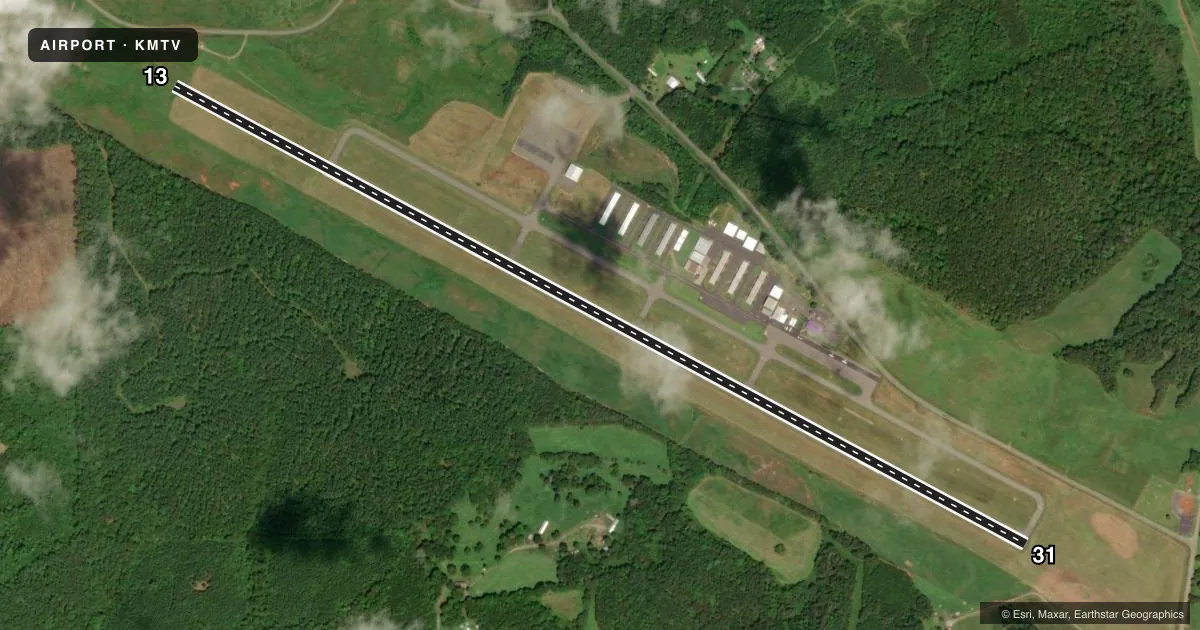
Runways & pattern
Full pagePattern entry · RWY 13
LEFT TRAFFICRunway end performance
| End | TORA | TODA | ASDA | LDA | VGSI | Approach lights | Obstruction |
|---|---|---|---|---|---|---|---|
| 13 | — | — | — | — | PAPI 4-box left(3.5°) | — | 85', tree, 2801' from thr, 524' R of cntrln, slope 30 |
| 31 | — | — | — | — | PAPI 4-box left(3°) | ODALS | 36', tree, 1104' from thr, 296' R of cntrln, slope 25 |
Declared distances in feet. TORA = takeoff run available, TODA = takeoff distance, ASDA = accelerate-stop, LDA = landing distance.
Airport sketch
Runways drawn to scale from FAA survey coordinates, rendered over satellite imagery. Not for navigation.
Approaches & charts
ILS · 1
Services on the field
Fuel grades, oxygen, maintenance, ramp storage and lighting — as declared to the FAA by the airport operator.
Fuel & services
- Fuel
- 100LLA+
- Oxygen (bottled)
- HIGH/LOW
- Oxygen (bulk)
- HIGH/LOW
- Airframe repair
- Major
- Power plant repair
- Major
- Other services
- CHTR,INSTR,RNTL,SALES
Ramp & ground
- Transient storage
- Tie-down
- Landing fee
- No fee published
- Customs
- Not available
- Lighting schedule
- SEE RMK
- Beacon schedule
- SS-SR
- Beacon
- White / Green (civil land)(WG)
- Wind indicator
- Lighted
- Segmented circle
- Yes
Fuel & FBOs
Cheapest 100LL and Jet A on the field and nearby. Always confirm with the FBO before taxi.
Airport notes
Surface conditions, obstructions, local procedures, lighting outages and other notes published with each FAA cycle.
General notes
- DEER ON AND INVOF ARPT.
- FOR CD CTC GREENSBORO APCH AT 743-222-6129.
- COLD TEMPERATURE AIRPORT. ALTITUDE CORRECTION REQUIRED AT OR BELOW -16C.
Lighting notes
- ACTVT REIL RWY 13 & 31; ODALS RWY 31; PAPI RWY 13 & 31; MIRL RWY 13/31 - CTAF.
Other notes
- MANAGERMANAGER CELL: 276-358-0749.
VFR map & nearby airports
VFR sectional. Tap any ICAO chip to open that airport.
Key facts · KMTV
Answer card- ICAO
- KMTV
- Name
- BLUE RIDGE
- Location
- MARTINSVILLE, VIRGINIA
- Elevation
- 948 ft MSL
- Traffic pattern altitude
- 1,948 ft MSL (1,000 AGL)
- Control tower
- Non-towered (use CTAF)
- Total runways
- 1
- Longest runway
- 13/31 · 6,077 ft
- Published ILS approaches
- 1
- Published frequencies
- 5
- Magnetic variation
- 7°
- Current flight rules
- LIFR
- Current wind
- 000° at 0 kt
- Favored runway now
- –
Blue Ridge Airport sits in Martinsville, Virginia. The field elevation is 940.9 ft MSL. It has one runway, 13/31, which is 5,002 ft long. There is no control tower. Use CTAF 122.7 or UNICOM 122.7 for local traffic calls.
The airport has one ILS approach to Runway 31. Runway 31 also has an omnidirectional approach lighting system, PAPI and medium intensity runway lights. Runway 13 has PAPI and medium intensity runway lights too. The published pattern altitude is not listed, so use the standard 1,000 ft AGL pattern unless the current Chart Supplement says otherwise. That puts the light-piston pattern at about 1,941 ft MSL here.
Blue Ridge Airport is served by Blue Ridge Airport on the field. It carries 100LL and Jet A. Call the FBO directly at (276) 957-2291 for current services. The remarks also note deer on and near the airport. Runway 13 is unusable beyond 9 degrees right of centerline. This is a cold temperature airport. Altitude correction is required at or below minus 16 degrees Celsius. For clearance delivery, contact Greensboro Approach at 743-222-6129. Pilots should plan for a non-towered field with published approach support from Greensboro. Stay alert for wildlife on taxi and final.