METAR & TAF KZEF
KZEF does not publish a METAR.
Showing the nearest reporting station: KUKF (WILKES COUNTY) · 15.5 NM away. Conditions at KZEF may differ.
METAR · KUKF
Observed 12:15Z
KUKF 271215Z AUTO 00000KT 10SM CLR 20/20 A2998 RMK AO2
- Wind
- 000° @ 0 kt
- Visibility
- 10 SM
- Temp / Dew
- 20°C / 20°C
- Altimeter
- 29.98 inHg
- Clouds
- CLR
- Density alt
- 1,849 ft
- Ceiling
- Unlimited
- Rules
- VFR
Airport info & contacts
Manager on record, flight service, ARTCC, attendance schedule and pattern altitude — published by the FAA and refreshed every 28 days.
Location
- From city
- 3 NM NE
- VFR sectional
- CINCINNATI
- ARTCC
- ZTL · ATLANTA
- NOTAM facility
- RDU (NOTAM-D)
Airport manager
- Name
- STEVE (SANDY) SHORE
- Phone
- 336-366-3433
- Address
- 1598 CC CAMP ROAD, ELKIN NC 28621
Flight service · Hours
- FSS RDU
- RALEIGH1-800-WX-BRIEF
- Attendance
- 0900-1700
Frequencies
Tap any row to copy the frequency to your clipboard.
Runways & pattern
Full pagePattern entry · RWY 07
LEFT TRAFFICRunway end performance
| End | TORA | TODA | ASDA | LDA | VGSI | Approach lights | Obstruction |
|---|---|---|---|---|---|---|---|
| 07 | — | — | — | — | PAPI 2-box left(3°) | — | 26', trees, 394' from thr, 147' R of cntrln, slope 7 |
| 25 | — | — | — | — | PAPI 2-box left(3°) | — | 50', trees, 331' from thr, 203' R of cntrln, slope 2 |
Declared distances in feet. TORA = takeoff run available, TODA = takeoff distance, ASDA = accelerate-stop, LDA = landing distance.
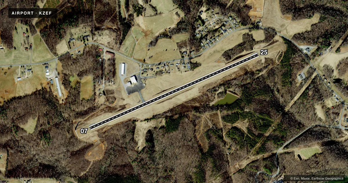
Airport sketch
Runways drawn to scale from FAA survey coordinates, rendered over satellite imagery. Not for navigation.
Approaches & charts
Services on the field
Fuel grades, oxygen, maintenance, ramp storage and lighting — as declared to the FAA by the airport operator.
Fuel & services
- Fuel
- 100LLA1+
- Oxygen (bottled)
- HIGH/LOW
- Oxygen (bulk)
- Not available
- Airframe repair
- Major
- Power plant repair
- Major
- Other services
- AMB,INSTR
Ramp & ground
- Transient storage
- Tie-down
- Hangar
- Landing fee
- No fee published
- Customs
- Not available
- Lighting schedule
- SEE RMK
- Beacon schedule
- SS-SR
- Beacon
- White / Green (civil land)(WG)
- Wind indicator
- Lighted
- Segmented circle
- Yes
Fuel & FBOs
Cheapest 100LL and Jet A on the field and nearby. Always confirm with the FBO before taxi.
Airport notes
Surface conditions, obstructions, local procedures, lighting outages and other notes published with each FAA cycle.
General notes
- RWY 07 SAFETY AREA HAS 80+ FT DROP-OFF AT END AND 90 FT BOTH SIDES OF CNTRLN.
- DEER ON AND INVOF ARPT.
- RWY 25 HAS AN UPHILL GRADE.
- FOR SERVICE AFTER HOURS CALL (336)-874-7171, (336)-874-2931, (336)-366-7994, OR (336)-926-6243.
- FOR CD CTC ATLANTA ARTCC AT 770-210-7692.
- RWY 25 HAS UP TO 100+ FT DROP-OFF FIRST 600 FT AND 90 FT BOTH SIDES OF CNTRLN.
- RWY 25 HAS UNMARKED POWER LINES 800 FT FM THR BOTH SIDES OF CNTRLN.
Lighting notes
- ACTVT REIL RWY 07 & 25; PAPI RWY 07 & 25; MIRL RWY 07/25 - CTAF.
Fuel notes
- 100LL24 HR SELF SERVICE W/ CREDIT CARD.
Approach & departure obstructions
- 2556 FT TREES 171 FT FM THR OFFSET 228 FT RIGHT OF CNTRLN.
- 07UNUSBL 7 DEG LEFT AND RIGHT OF RCL.
- 25UNUSBL 9 DEG RIGHT OF RCL.
Other notes
- MIN ALT 500 FT AGL BASE TURN TO FINAL RWY 25.
VFR map & nearby airports
VFR sectional. Tap any ICAO chip to open that airport.
Key facts · KZEF
Answer card- ICAO
- KZEF
- Name
- ELKIN MUNI
- Location
- ELKIN, NORTH CAROLINA
- Elevation
- 1,067.2 ft MSL
- Traffic pattern altitude
- 2,067.2 ft MSL (1,000 AGL)
- Control tower
- Non-towered (use CTAF)
- Total runways
- 1
- Longest runway
- 07/25 · 4,001 ft
- Published ILS approaches
- 0
- Published frequencies
- 2
- Magnetic variation
- 8°
- Current flight rules
- VFR
- Current wind
- 000° at 0 kt
- Favored runway now
- –
Elkin Muni is in Elkin, North Carolina. The field elevation is 1,067.2 ft MSL. It has one runway, 07/25. The longest runway is 4,001 ft of asphalt. There is no control tower. CTAF and UNICOM are both 123.05. No ILS approaches are published here.
Pattern altitude is not published. Use 1,000 ft AGL for light piston operations unless the current Chart Supplement says otherwise. The field sits in a higher-elevation part of northwest North Carolina. That means density altitude can matter on warm days. Runway 25 has an uphill grade. It also has unmarked power lines 800 ft from the threshold on both sides of the centerline. Trees are listed near the runway 25 threshold too. Runway 07 has a safety area with a sharp drop-off beyond the end.
Yadkin Valley Aviation is on the field. It carries 100LL and Jet A. 100LL is available 24 hours self-serve with credit card. Published remarks also note runway end identifier lights, PAPI and medium intensity runway lights on 07/25. Deer are reported on and near the airport. If you need clearance delivery, contact Atlanta ARTCC. For after-hours service, call the numbers in the current Chart Supplement or the airport operator before you go.