METAR & TAF KMKJ
Current METAR
Observed 12:35Z
KMKJ 271235Z AUTO 00000KT M1/4SM FG OVC002 19/18 A3004 RMK AO2 T01910177
- Wind
- 000° @ 0 kt
- Visibility
- —
- Temp / Dew
- 19°C / 18°C
- Altimeter
- 30.04 inHg
- Clouds
- OVC
- Density alt
- 3,503 ft
- Ceiling
- 200 ft AGL
- Rules
- LIFR
Airport info & contacts
Manager on record, flight service, ARTCC, attendance schedule and pattern altitude — published by the FAA and refreshed every 28 days.
Location
- From city
- 9 NM NE
- VFR sectional
- CINCINNATI
- ARTCC
- ZTL · ATLANTA
- NOTAM facility
- MKJ (NOTAM-D)
Airport manager
- Name
- BRIAN BURKETT
- Phone
- 276-783-8805
- Address
- 8223 LEE HIGHWAY, RURAL RETREAT VA 24368
Flight service · Hours
- FSS DCA
- LEESBURG1-800-WX-BRIEF
- Attendance
- MON-SAT · 0800-1800
- SUN · CLOSED
Frequencies
Tap any row to copy the frequency to your clipboard.
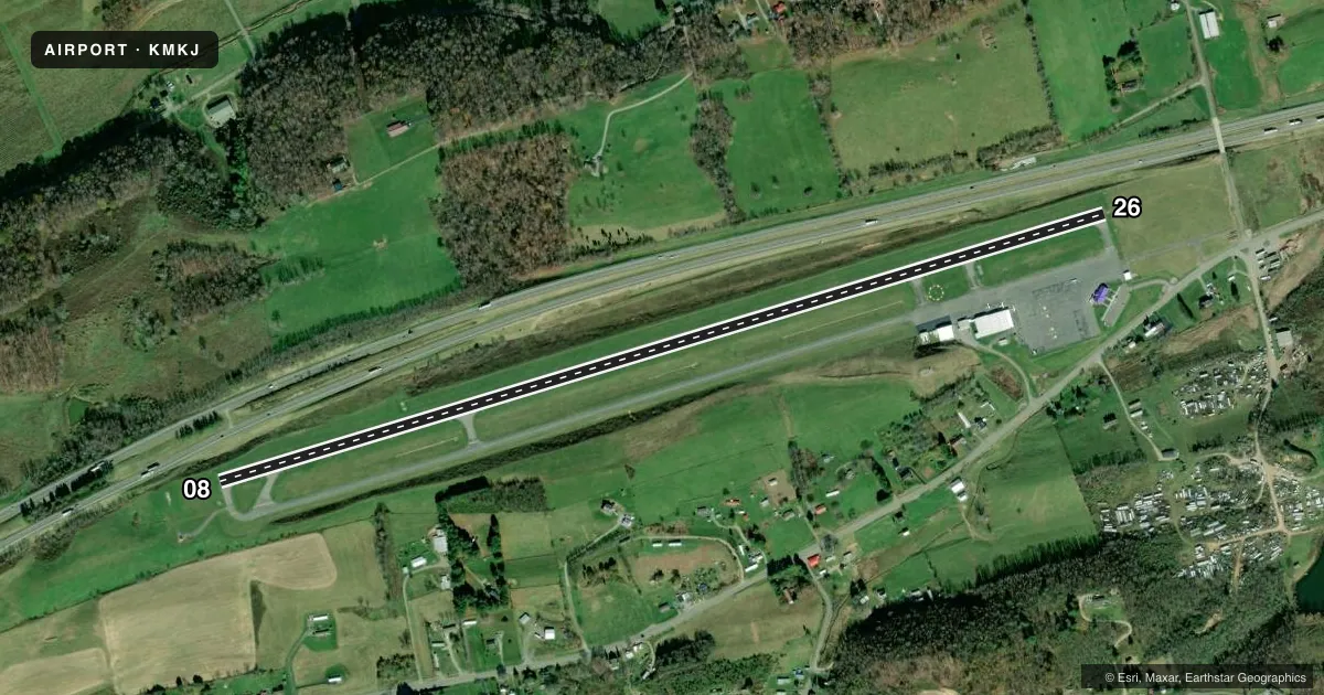
Runways & pattern
Full pagePattern entry · RWY 08
LEFT TRAFFICRunway end performance
| End | TORA | TODA | ASDA | LDA | VGSI | Approach lights | Obstruction |
|---|---|---|---|---|---|---|---|
| 08 | — | — | — | — | PAPI 2-box left(3°) | — | 26', trees, 612' from thr, 213' R of cntrln, slope 15 |
| 26 | — | — | — | — | PAPI 2-box left(3.75°) | — | 44', tree, 711' from thr, 321' R of cntrln, slope 11 |
Declared distances in feet. TORA = takeoff run available, TODA = takeoff distance, ASDA = accelerate-stop, LDA = landing distance.
Airport sketch
Runways drawn to scale from FAA survey coordinates, rendered over satellite imagery. Not for navigation.
Approaches & charts
ILS · 1
Services on the field
Fuel grades, oxygen, maintenance, ramp storage and lighting — as declared to the FAA by the airport operator.
Fuel & services
- Fuel
- 100LLA+
- Oxygen (bottled)
- Not available
- Oxygen (bulk)
- Not available
- Airframe repair
- Major
- Power plant repair
- Major
Ramp & ground
- Transient storage
- Tie-down
- Hangar
- Landing fee
- No fee published
- Customs
- Not available
- Lighting schedule
- SEE RMK
- Beacon schedule
- SS-SR
- Beacon
- White / Green (civil land)(WG)
- Wind indicator
- Lighted
- Segmented circle
- Yes
Fuel & FBOs
Cheapest 100LL and Jet A on the field and nearby. Always confirm with the FBO before taxi.
Airport notes
Surface conditions, obstructions, local procedures, lighting outages and other notes published with each FAA cycle.
General notes
- AFT HRS CTC 276-685-1122.
- FOR CD CTC ATLANTA ARTCC AT 770-210-7692.
Lighting notes
- MIRL RWY 08/26 PRESET LOW INTST; ACTVT HIGHER INTST - CTAF.
Approach & departure obstructions
- 088 FT BUSH 80 FT FRM THLD, 120 L OF CNTRLN ON APCH.
- 2617 FT ROADWAY CLNC PENETRATES APCH BY 9 FT. INTERSTATE TFC PENETRATES INTO PRI SFC.
Other notes
- THIS AIRPORT HAS BEEN SURVEYED BY THE NATIONAL GEODETIC SURVEY.
- IN OPERATION PRIOR 1959.
- LCTD 9 NM NE MARION.
- 8CALL 276-685-9314
VFR map & nearby airports
VFR sectional. Tap any ICAO chip to open that airport.
Key facts · KMKJ
Answer card- ICAO
- KMKJ
- Name
- MOUNTAIN EMPIRE
- Location
- MARION/WYTHEVILLE, VIRGINIA
- Elevation
- 2,558.2 ft MSL
- Traffic pattern altitude
- 3,558.2 ft MSL (1,000 AGL)
- Control tower
- Non-towered (use CTAF)
- Total runways
- 1
- Longest runway
- 08/26 · 5,252 ft
- Published ILS approaches
- 1
- Published frequencies
- 2
- Magnetic variation
- 6°
- Current flight rules
- LIFR
- Current wind
- 000° at 0 kt
- Favored runway now
- –
Mountain Empire Airport sits near Marion and Wytheville in Virginia. The field elevation is 2,558.2 ft MSL. It has one runway. Runway 08/26 is 5,252 ft long with asphalt pavement. The airport is non-towered. CTAF and UNICOM are both 122.7. The published ILS serves runway 26.
Pattern altitude is not published. Use the standard 1,000 ft AGL pattern unless the current Chart Supplement says otherwise. That puts the light piston pattern at about 3,558 ft MSL based on the listed field elevation. The on-field FBO is Mountain Empire Airport. It carries 100LL, Jet A and Jet A Prist. Call (276) 783-8805 for current service details.
There are a few items worth planning for. An 8-foot bush sits near the runway 08 approach path. Runway 26 has a roadway clearance issue noted in the remarks. Medium intensity runway lights on 08/26 start at low intensity. Higher intensity is activated on CTAF. The airport is in a higher-elevation part of Virginia, so expect performance and density altitude to matter more than at lowland fields. Check the current Chart Supplement for any noise or operational notes before you go. The remarks also list after-hours and clearance delivery contact numbers for current coordination.