METAR & TAF KUKF
Current METAR
Observed 12:15Z
KUKF 271215Z AUTO 00000KT 10SM CLR 20/20 A2998 RMK AO2
- Wind
- 000° @ 0 kt
- Visibility
- 10 SM
- Temp / Dew
- 20°C / 20°C
- Altimeter
- 29.98 inHg
- Clouds
- CLR
- Density alt
- 2,142 ft
- Ceiling
- Unlimited
- Rules
- VFR
Airport info & contacts
Manager on record, flight service, ARTCC, attendance schedule and pattern altitude — published by the FAA and refreshed every 28 days.
Location
- From city
- 4 NM NE
- VFR sectional
- CINCINNATI
- ARTCC
- ZTL · ATLANTA
- NOTAM facility
- UKF (NOTAM-D)
Airport manager
- Name
- DUSTIN CAUDILL
- Phone
- 336-696-2000
- Address
- 640 WOOD WALLACE, NORTH WILKESBORO NC 28659
Flight service · Hours
- FSS RDU
- RALEIGH1-800-WX-BRIEF
- Attendance
- DAWN-DUSK
Frequencies
Tap any row to copy the frequency to your clipboard.
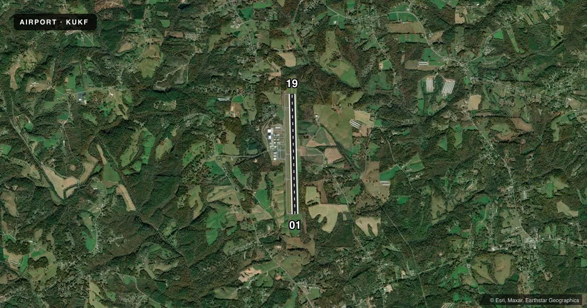
Runways & pattern
Full pagePattern entry · RWY 01
LEFT TRAFFICRunway end performance
| End | TORA | TODA | ASDA | LDA | VGSI | Approach lights | Obstruction |
|---|---|---|---|---|---|---|---|
| 01 | — | — | — | — | PAPI 2-box left(3°) | MALSR | 9', trees, 260' from thr, 243' R of cntrln, slope 6 |
| 19 | — | — | — | — | PAPI 2-box left(3°) | — | 62', trees, 632' from thr, 329' R of cntrln, slope 6 |
Declared distances in feet. TORA = takeoff run available, TODA = takeoff distance, ASDA = accelerate-stop, LDA = landing distance.
Airport sketch
Runways drawn to scale from FAA survey coordinates, rendered over satellite imagery. Not for navigation.
Approaches & charts
ILS · 1
Services on the field
Fuel grades, oxygen, maintenance, ramp storage and lighting — as declared to the FAA by the airport operator.
Fuel & services
- Fuel
- 100LLA1+
- Oxygen (bottled)
- HIGH/LOW
- Oxygen (bulk)
- Not available
- Airframe repair
- Major
- Power plant repair
- Major
- Other services
- CHTR,INSTR
Ramp & ground
- Transient storage
- Tie-down
- Lighting schedule
- SEE RMK
- Beacon schedule
- SS-SR
- Beacon
- White / Green (civil land)(WG)
- Wind indicator
- Lighted
- Segmented circle
- Yes
Fuel & FBOs
Cheapest 100LL and Jet A on the field and nearby. Always confirm with the FBO before taxi.
Airport notes
Surface conditions, obstructions, local procedures, lighting outages and other notes published with each FAA cycle.
General notes
- DEER ON & INVOF ARPT.
- NO LINE OF SIGHT BTN RWY ENDS.
- FOR CD IF UNA TO CTC ON FSS FREQ, CTC ATLANTA ARTCC AT 770-210-7692.
- THERE IS AN UNLGTD WATER TANK IN THE APCH OF RWY 01.
Lighting notes
- ACTVT MALSR RWY 01; REIL 19; PAPI RWY 01 & 19; MIRL RWY 01/19; TWY LGTS - CTAF.
Fuel notes
- 100LLFUELING DRG RGLR FBO BUS HRS, PLUS 24 HRS CALL-OUT SVC (WITH PRIOR ARNGMT AND/OR A CALLOUT FEE); CALL FBO FOR DETAILS.
Approach & departure obstructions
- 0110 FT BRUSH 50 FT FM THR OFFSET 436 FT R OF CNTRLN.
- 1933 FT TREES 89 FT FM THR OFFSET 285 FT L OF CNTRLN.
- 01RWY 01 PAPI UNUSBL BYD 8 DEGS RIGHT OF CNTRLN.
Other notes
- 1ARPT UNATNDD THANKSGIVING & CHRISTMAS.
- MANAGERFOR SVC AFT HRS CALL NR POSTED ON DOOR.
VFR map & nearby airports
VFR sectional. Tap any ICAO chip to open that airport.
Key facts · KUKF
Answer card- ICAO
- KUKF
- Name
- WILKES COUNTY
- Location
- NORTH WILKESBORO, NORTH CAROLINA
- Elevation
- 1,303.4 ft MSL
- Traffic pattern altitude
- 2,303.4 ft MSL (1,000 AGL)
- Control tower
- Non-towered (use CTAF)
- Total runways
- 1
- Longest runway
- 01/19 · 6,201 ft
- Published ILS approaches
- 1
- Published frequencies
- 2
- Magnetic variation
- 8°
- Current flight rules
- VFR
- Current wind
- 000° at 0 kt
- Favored runway now
- –
Wilkes County Airport sits in North Wilkesboro, North Carolina. Field elevation is 1,303.4 ft MSL. The airport has one runway. Runway 01/19 is 6,201 ft long with asphalt pavement. There is no control tower. CTAF and UNICOM are both 122.7. The field has one ILS approach to runway 01. Pattern altitude is not published. Plan on the standard 1,000 ft AGL unless the current FAA Chart Supplement says otherwise.
Wilkes County Airport has one on-field FBO. Wilkes County Airport carries 100LL and Jet A. Fueling is available during normal FBO hours. There is also 24-hour call-out service with prior arrangement or a callout fee. Call the FBO directly for current details. The published remarks also note that the airport is unattended on Thanksgiving and Christmas.
This is a field where the details matter. Runway 01 has approach lighting, sequenced flashing lights and a PAPI. Runway 19 has a PAPI and runway end identifier lights. The airport also has medium intensity runway lights. Deer are reported on and near the airport. There is no line of sight between runway ends. There is an unlighted water tank in the approach to runway 01. The runway 01 PAPI is unusable beyond 8 degrees right of centerline. Check the current FAA Chart Supplement for any current operational notes before you go.