METAR & TAF 80C
80C does not publish a METAR.
Showing the nearest reporting station: KSVH (STATESVILLE RGNL) · 21.9 NM away. Conditions at 80C may differ.
METAR · KSVH
Observed 11:15Z
KSVH 271115Z AUTO 00000KT 1/2SM FG OVC001 22/22 A2992 RMK AO2 T02150215
- Wind
- 000° @ 0 kt
- Visibility
- 0.5 SM
- Temp / Dew
- 22°C / 22°C
- Altimeter
- 29.92 inHg
- Clouds
- OVC
- Density alt
- 2,099 ft
- Ceiling
- 100 ft AGL
- Rules
- LIFR
Airport info & contacts
Manager on record, flight service, ARTCC, attendance schedule and pattern altitude — published by the FAA and refreshed every 28 days.
Location
- From city
- 6 NM S
- VFR sectional
- CINCINNATI
- ARTCC
- ZTL · ATLANTA
- NOTAM facility
- RDU (NOTAM-D)
Airport manager
- Name
- HAROLD DEAN HOLCOMB
- Phone
- (336) 468-0641
- Address
- 1205 RUNWAY TRAIL, YADKINVILLE NC 27055
Flight service · Hours
- FSS RDU
- RALEIGH1-800-WX-BRIEF
- Attendance
- IREG
Frequencies
Tap any row to copy the frequency to your clipboard.
Runways & pattern
Full pagePattern entry · RWY 16
LEFT TRAFFICRunway end performance
| End | TORA | TODA | ASDA | LDA | VGSI | Approach lights | Obstruction |
|---|---|---|---|---|---|---|---|
| 16 | — | — | — | — | — | — | 60', tree, 107' from thr, 68' R of cntrln, slope 1 |
| 34 | — | — | — | — | — | — | 24', trees, 140' from thr, 63' R of cntrln, slope 5 |
Declared distances in feet. TORA = takeoff run available, TODA = takeoff distance, ASDA = accelerate-stop, LDA = landing distance.
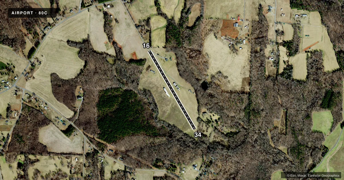
Airport sketch
Runways drawn to scale from FAA survey coordinates, rendered over satellite imagery. Not for navigation.
Approaches & charts
Services on the field
Fuel grades, oxygen, maintenance, ramp storage and lighting — as declared to the FAA by the airport operator.
Fuel & services
- Fuel
- Not available
Ramp & ground
- Transient storage
- Not published
- Wind indicator
- Yes
- Segmented circle
- No
Fuel & FBOs
Cheapest 100LL and Jet A on the field and nearby. Always confirm with the FBO before taxi.
Airport notes
Surface conditions, obstructions, local procedures, lighting outages and other notes published with each FAA cycle.
General notes
- ACFT OPERATING FM PINEY RIDGE ARPT 1.3 MI NW.
- UNMARKED PLINES 500-1000 FT N RWY 16 THR.
- RWY 16/34 HAS 3% GRADE; WINDS PERMITTING TKOF RWY 16 LND RWY 34.
- NO FLIGHT TRAINING OR STUDENT PILOTS; ONLY EXPERIENCED PILOTS PERMITTED.
- RWY 16 DEPARTURES MAKE LEFT TURN FOR NOISE & OBSTRUCTION AVOIDANCE.
- FOR CD CTC ATLANTA ARTCC AT 770-210-7692.
- RWY CLOSED TO TURBINE AIRCRAFT AND GROSS WEIGHTS GREATER THAN 5000 POUNDS EXCEPT WITH PRIOR PERMISSION (DUE TO SOFT TURF).
- RWY 16 APCH HAS 62 FT TREE 111 FT FM RWY END OFFSET 73 FT LEFT.
Other notes
- PRVDD VFR; WIND INDICATOR IS MAINTAINED; NO NGT OPNS WITHOUT LIGHTING; WRITTEN AGREEMENT WITH PINEY RIDGE ARPT.
VFR map & nearby airports
VFR sectional. Tap any ICAO chip to open that airport.
Key facts · 80C
Answer card- ICAO
- 80C
- Name
- LONE HICKORY
- Location
- YADKINVILLE, NORTH CAROLINA
- Elevation
- 1,015 ft MSL
- Traffic pattern altitude
- 2,015 ft MSL (1,000 AGL)
- Control tower
- Non-towered (use CTAF)
- Total runways
- 1
- Longest runway
- 16/34 · 2,000 ft
- Published ILS approaches
- 0
- Published frequencies
- 1
- Magnetic variation
- 6°
- Current flight rules
- LIFR
- Current wind
- 000° at 0 kt
- Favored runway now
- –
Lone Hickory sits near Yadkinville, North Carolina. Field elevation is 1,015 ft MSL. The airport has one runway. Runway 16/34 is 2,000 ft long and turf. No tower is published, so use CTAF 122.9 and standard see-and-avoid discipline. No ILS approaches are published here.
The pattern altitude is not published. Use the standard 1,000 ft AGL pattern unless current local guidance says otherwise. The field is set up for VFR use. The FAA remarks also say only experienced pilots are allowed. No flight training or student pilots are permitted. That matters if you are planning a first stop in a new airplane.
Runway 16 has a few things to brief before arrival. There is a 62-foot tree near the approach end, offset left of the centerline. Unmarked power lines also sit north of the runway 16 threshold. Runway 16 departures call for a left turn for noise and obstruction avoidance. The runway has a 3 percent grade. When winds allow, takeoff is from runway 16 and landing is on runway 34. The runway is closed to turbine aircraft and to aircraft over 5,000 pounds gross weight unless prior permission is obtained. There are no on-field FBOs listed. Aircraft also operate from Piney Ridge Airport 1.3 miles northwest. For clearance delivery, contact Atlanta ARTCC at 770-210-7692.