METAR & TAF 8A7
8A7 does not publish a METAR.
Showing the nearest reporting station: KEXX (DAVIDSON COUNTY EXEC) · 11.0 NM away. Conditions at 8A7 may differ.
METAR · KEXX
Observed 16:35Z
KEXX 251635Z AUTO 00000KT 10SM OVC008 21/21 A3012 RMK AO2 T02120212
- Wind
- 000° @ 0 kt
- Visibility
- 10 SM
- Temp / Dew
- 21°C / 21°C
- Altimeter
- 30.12 inHg
- Clouds
- OVC
- Density alt
- 1,486 ft
- Ceiling
- 800 ft AGL
- Rules
- IFR
Airport info & contacts
Manager on record, flight service, ARTCC, attendance schedule and pattern altitude — published by the FAA and refreshed every 28 days.
Location
- From city
- 5 NM NE
- VFR sectional
- CHARLOTTE
- ARTCC
- ZTL · ATLANTA
- NOTAM facility
- RDU (NOTAM-D)
Airport manager
- Name
- BRIAN MEADOWS
- Phone
- 336-998-8101
- Address
- 1105 FORK BIXBY RD, ADVANCE NC 27006
Flight service · Hours
- FSS RDU
- RALEIGH1-800-WX-BRIEF
- Attendance
- 0800-1700
Frequencies
Tap any row to copy the frequency to your clipboard.
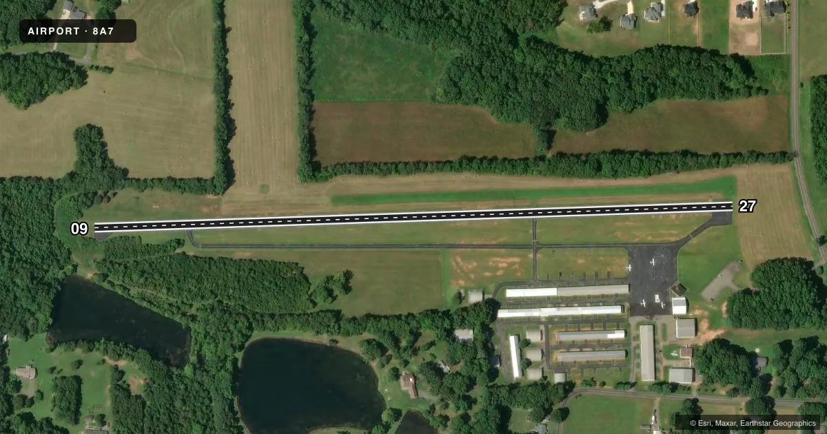
Runways & pattern
Full pagePattern entry · RWY 09
LEFT TRAFFICRunway end performance
| End | TORA | TODA | ASDA | LDA | VGSI | Approach lights | Obstruction |
|---|---|---|---|---|---|---|---|
| 09 | — | — | — | — | PAPI 2-box left(3.5°) | — | 11', trees, 222' from thr, 18' R of cntrln, slope 2 |
| 27 | — | — | — | — | — | — | 75', trees, 401' from thr, 186' R of cntrln, slope 2 |
Declared distances in feet. TORA = takeoff run available, TODA = takeoff distance, ASDA = accelerate-stop, LDA = landing distance.
Airport sketch
Runways drawn to scale from FAA survey coordinates, rendered over satellite imagery. Not for navigation.
Approaches & charts
Services on the field
Fuel grades, oxygen, maintenance, ramp storage and lighting — as declared to the FAA by the airport operator.
Fuel & services
- Fuel
- 100LL
- Oxygen (bottled)
- Low pressure
- Oxygen (bulk)
- Not available
- Airframe repair
- Major
- Power plant repair
- Major
- Other services
- AVNCS,INSTR,SALES
Ramp & ground
- Transient storage
- Tie-down
- Landing fee
- No fee published
- Lighting schedule
- SS-SR
- Beacon schedule
- SS-SR
- Beacon
- White / Green (civil land)(WG)
- Wind indicator
- Yes
- Segmented circle
- No
Fuel & FBOs
Cheapest 100LL and Jet A on the field and nearby. Always confirm with the FBO before taxi.
Airport notes
Surface conditions, obstructions, local procedures, lighting outages and other notes published with each FAA cycle.
General notes
- RWY 09 -18 FT DROP-OFF 150 FT FROM THR LEFT & RIGHT OF CNTRLN.
- RWY 09 UPHILL GRADE.
- DEER/MIGRATORY BIRDS OCNLLY ON ARPT.
- FOR CD CTC GREENSBORO APCH AT 336-333-5119.
- FOR AFT HRS SVC CTC 336-998-2126.
Fuel notes
- 100LL24 HR SELF SERVICE WITH CC.
Runway surface & condition
- 09/27RWY 09/27 NSTD LIGHTING DUE TO NUMBER AND LOCATION.
Approach & departure obstructions
- 09HAS 10-15 FT BRUSH STARTING 0-200 FT FM THR OFFSET 37-58 FT R OF CNTRLN AND HAS 12-31 FT BRUSH 0-200 FT FM THR OFFSET 55-95 FT L OF CNTRLN.
- 09RWY 09 MARKINGS NONSTANDARD DUE TO SIZE AND LOCATION.
- 27RWY 27 MARKINGS NONSTANDARD DUE TO SIZE AND LOCATION.
Other notes
- THIS AIRPORT HAS BEEN SURVEYED BY THE NATIONAL GEODETIC SURVEY.
VFR map & nearby airports
VFR sectional. Tap any ICAO chip to open that airport.
Key facts · 8A7
Answer card- ICAO
- 8A7
- Name
- TWIN LAKES
- Location
- MOCKSVILLE, NORTH CAROLINA
- Elevation
- 818 ft MSL
- Traffic pattern altitude
- 1,818 ft MSL (1,000 AGL)
- Control tower
- Non-towered (use CTAF)
- Total runways
- 1
- Longest runway
- 09/27 · 2,943 ft
- Published ILS approaches
- 0
- Published frequencies
- 4
- Magnetic variation
- 6°
- Current flight rules
- IFR
- Current wind
- 000° at 0 kt
- Favored runway now
- –
Twin Lakes Airport (8A7) sits in Mocksville, North Carolina. Field elevation is 818 ft MSL. The airport has one runway. Runway 09/27 is 2,943 ft long with an asphalt surface. There is no control tower. CTAF and UNICOM are both 122.7. Greensboro Approach handles approach and departure work on 124.35 and 269.225. No ILS approaches are published here.
The published pattern altitude is not listed. Use the standard 1,000 ft AGL for light piston operations unless the current FAA Chart Supplement says otherwise. The field is surveyed by the National Geodetic Survey. That matters if you care about precise airport reference data.
Twin Lakes Airport has on-field FBO service from Twin Lakes Airport. It carries 100LL. 24-hour self-serve fuel with credit card is available. For after-hours service, the published number is 336-998-2126. Runway 09 has an uphill grade. The FAA also notes nonstandard runway markings and lighting on 09/27. There is an 18-foot drop-off near the 09 threshold. Brush is also reported near the 09 end. Deer and migratory birds are occasionally on the airport. A first-time pilot should plan a careful look at the runway environment, especially on 09. Verify current airport notes with the FAA Chart Supplement before arrival.