METAR & TAF KEXX
Current METAR
Observed 10:15Z
KEXX 271015Z AUTO 00000KT 1 1/4SM BR BKN002 21/21 A2987 RMK AO2 T02100210
- Wind
- 000° @ 0 kt
- Visibility
- 0.25 SM
- Temp / Dew
- 21°C / 21°C
- Altimeter
- 29.87 inHg
- Clouds
- BKN
- Density alt
- 1,690 ft
- Ceiling
- 200 ft AGL
- Rules
- LIFR
Airport info & contacts
Manager on record, flight service, ARTCC, attendance schedule and pattern altitude — published by the FAA and refreshed every 28 days.
Location
- From city
- 3 NM SW
- VFR sectional
- CHARLOTTE
- ARTCC
- ZTL · ATLANTA
- NOTAM facility
- EXX (NOTAM-D)
Airport manager
- Name
- KAREL VAN DER LINDEN
- Phone
- 336-956-7774
- Address
- 1673 AVIATION WAY, LEXINGTON NC 27292
Flight service · Hours
- FSS RDU
- RALEIGH1-800-WX-BRIEF
- Attendance
- 0800-1900
Frequencies
Tap any row to copy the frequency to your clipboard.
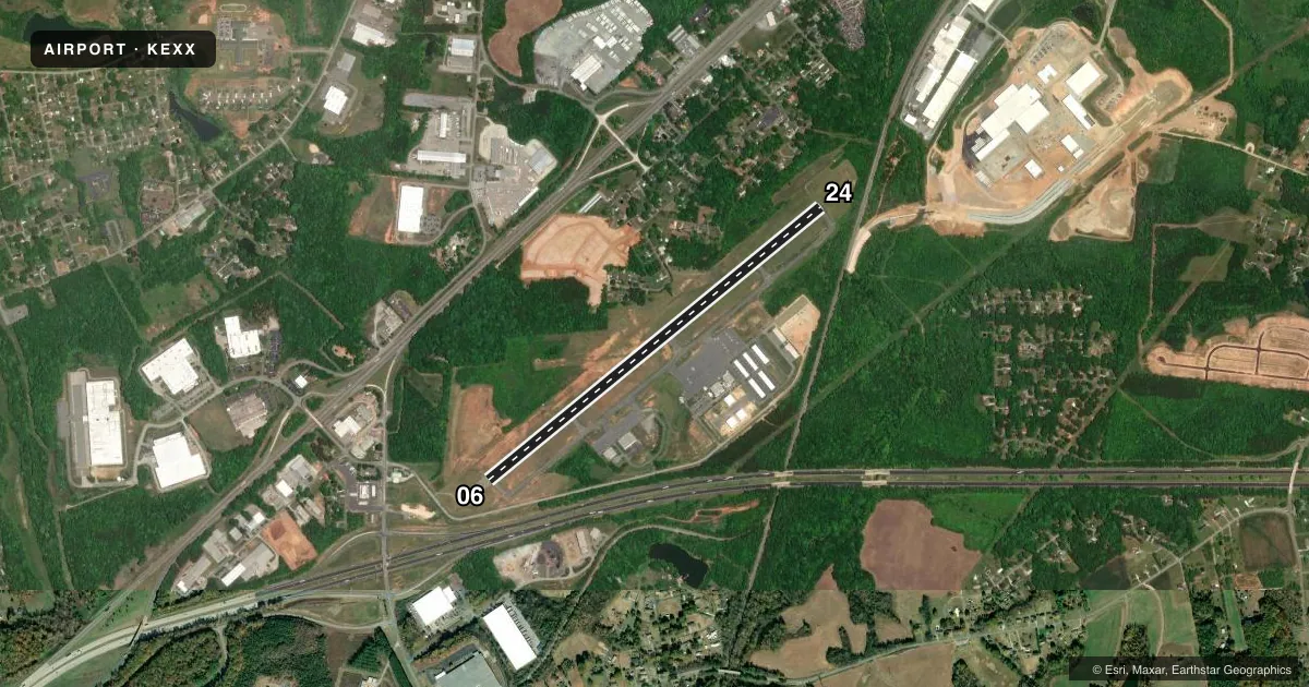
Runways & pattern
Full pagePattern entry · RWY 06
LEFT TRAFFICRunway end performance
| End | TORA | TODA | ASDA | LDA | VGSI | Approach lights | Obstruction |
|---|---|---|---|---|---|---|---|
| 06 | — | — | — | — | PAPI 2-box left(4°) | MALSR | 50', trees, 1879' from thr, 684' R of cntrln, slope 33 |
| 24 | — | — | — | — | PAPI 2-box left(3°) | — | 26', trees, 453' from thr, 39' R of cntrln, slope 9 |
Declared distances in feet. TORA = takeoff run available, TODA = takeoff distance, ASDA = accelerate-stop, LDA = landing distance.
Airport sketch
Runways drawn to scale from FAA survey coordinates, rendered over satellite imagery. Not for navigation.
Approaches & charts
ILS · 1
Services on the field
Fuel grades, oxygen, maintenance, ramp storage and lighting — as declared to the FAA by the airport operator.
Fuel & services
- Fuel
- 100LLA+
- Oxygen (bottled)
- Not available
- Oxygen (bulk)
- Not available
- Airframe repair
- Major
- Power plant repair
- Major
- Other services
- AMB,INSTR,RNTL
Ramp & ground
- Transient storage
- Tie-down
- Hangar
- Landing fee
- No fee published
- Customs
- Not available
- Lighting schedule
- SEE RMK
- Beacon schedule
- SS-SR
- Beacon
- White / Green (civil land)(WG)
- Wind indicator
- Lighted
- Segmented circle
- Yes
Fuel & FBOs
Cheapest 100LL and Jet A on the field and nearby. Always confirm with the FBO before taxi.
Airport notes
Surface conditions, obstructions, local procedures, lighting outages and other notes published with each FAA cycle.
General notes
- GCO AVBL ON FREQ 135.075 THRU GSO CD & FLT SVCS.
- MAX RAMP WT 30000 LBS SINGLE WHEEL, 60000 LBS DUAL WHEEL.
- FOLLOW TWY CNTRLN TO PRKG.
- WILDLIFE ON & INVOF ARPT.
- TWY A FM RWY 24 TO TWY A3 HAS DROP-OFF UP TO 60 FT 20 FT FM PAVEMENT EDGE.
- FOR CD CTC GREENSBORO APCH AT 743-222-6129. FOR CD IF UNA VIA GCO CTC ATLANTA ARTCC AT 770-210-7692.
Lighting notes
- ACTVT MALSR RWY 06; REILS RWY 24; PAPI RWY 06 & 24; MIRL RWY 06/24 - CTAF.
Fuel notes
- 100LL100LL 24 HR SELF SVC WITH CREDIT CARD.
Runway surface & condition
- 06/24PCR VALUE: 369/F/C/X/T
Other notes
- 1FOR SVC AFT HRS CALL 336-847-2983. UNATNDD JULY 4TH, THANKSGIVING, CHRISTMAS, NEW YEARS DAY.
VFR map & nearby airports
VFR sectional. Tap any ICAO chip to open that airport.
Key facts · KEXX
Answer card- ICAO
- KEXX
- Name
- DAVIDSON COUNTY EXEC
- Location
- LEXINGTON, NORTH CAROLINA
- Elevation
- 732.5 ft MSL
- Traffic pattern altitude
- 1,732.5 ft MSL (1,000 AGL)
- Control tower
- Non-towered (use CTAF)
- Total runways
- 1
- Longest runway
- 06/24 · 5,004 ft
- Published ILS approaches
- 1
- Published frequencies
- 4
- Magnetic variation
- 7°
- Current flight rules
- LIFR
- Current wind
- 000° at 0 kt
- Favored runway now
- –
Davidson County Exec is in Lexington, North Carolina. Field elevation is 732.5 ft MSL. The airport has one runway, 06/24, which is 5,004 ft long. There is no control tower. Traffic uses CTAF 122.8. Pattern altitude is not published, so plan on the standard 1,000 ft AGL for light piston traffic unless the current Chart Supplement says otherwise.
Runway 06 has an ILS. The field also has MALSR on 06. REILs are on 24. PAPI is on both ends. Runway lights are medium intensity on both ends. Fly High Lexington is on the field. It carries 100LL and Jet A Prist. 100LL is available 24 hours self-serve with credit card. Published remarks call out wildlife on and near the airport. They also note a drop-off near Taxiway A from runway 24 toward Taxiway A3, so taxi with care and stay on the centerline. The airport sits under Greensboro approach services, so have the current frequencies ready before arrival. This is a field where a first-time pilot should brief the runway lighting, the ILS on 06 and the taxi hazards before starting downwind.