METAR & TAF 78A
78A does not publish a METAR.
Showing the nearest reporting station: KUKF (WILKES COUNTY) · 11.3 NM away. Conditions at 78A may differ.
METAR · KUKF
Observed 06:55Z
KUKF 270655Z AUTO 7SM CLR 20/20 A2997 RMK AO2
- Wind
- Calm
- Visibility
- 7 SM
- Temp / Dew
- 20°C / 20°C
- Altimeter
- 29.97 inHg
- Clouds
- CLR
- Density alt
- 1,948 ft
- Ceiling
- Unlimited
- Rules
- VFR
Airport info & contacts
Manager on record, flight service, ARTCC, attendance schedule and pattern altitude — published by the FAA and refreshed every 28 days.
Location
- From city
- 3 NM SW
- VFR sectional
- CINCINNATI
- ARTCC
- ZTL · ATLANTA
- NOTAM facility
- RDU (NOTAM-D)
Airport manager
- Name
- HOLLIDAY H OBRECHT III
- Phone
- 704-495-9784
- Address
- P.O. BOX 675, JONESVILLE NC 28642
Flight service · Hours
- FSS RDU
- RALEIGH1-800-WX-BRIEF
- Attendance
- Unattended
Frequencies
Tap any row to copy the frequency to your clipboard.
Runways & pattern
Full pagePattern entry · RWY 10
LEFT TRAFFIC| Runway | Heading (°M) | Length | Surface | Traffic |
|---|---|---|---|---|
| 10/28 | 87° / 267° | 2,600 ft | TURF | 28 R |
| 02/20 | 10° / 190° | 921 ft | TURF | Standard L |
Runway end performance
| End | TORA | TODA | ASDA | LDA | VGSI | Approach lights | Obstruction |
|---|---|---|---|---|---|---|---|
| 10 | — | — | — | — | — | — | 65', trees, 74' from thr, 115' R of cntrln, slope 1 |
| 28 | — | — | — | — | — | — | 34', trees, 376' from thr, 47' R of cntrln, slope 11 |
| 02 | — | — | — | — | — | — | 56', trees, 218' from thr, 47' R of cntrln, slope 3 |
| 20 | — | — | — | — | — | — | 58', trees, 32' from thr, 119' R of cntrln, slope 0 |
Declared distances in feet. TORA = takeoff run available, TODA = takeoff distance, ASDA = accelerate-stop, LDA = landing distance.
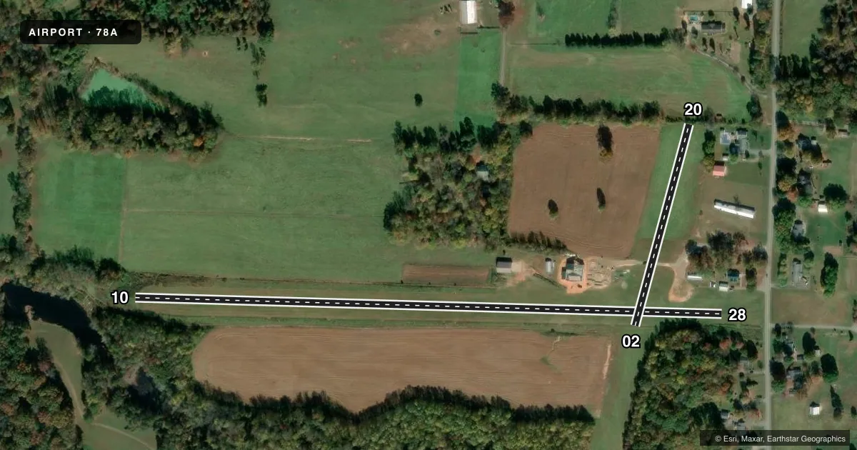
Airport sketch
Runways drawn to scale from FAA survey coordinates, rendered over satellite imagery. Not for navigation.
Approaches & charts
Services on the field
Fuel grades, oxygen, maintenance, ramp storage and lighting — as declared to the FAA by the airport operator.
Fuel & services
- Fuel
- Not available
- Oxygen (bottled)
- Not available
- Oxygen (bulk)
- Not available
- Airframe repair
- Not available
- Power plant repair
- Not available
- Other services
- GLD
Ramp & ground
- Transient storage
- Tie-down
- Landing fee
- No fee published
- Wind indicator
- No
- Segmented circle
- No
Fuel & FBOs
Cheapest 100LL and Jet A on the field and nearby. Always confirm with the FBO before taxi.
Airport notes
Surface conditions, obstructions, local procedures, lighting outages and other notes published with each FAA cycle.
General notes
- NO LINE-OF-SIGHT BTN RWY ENDS.
- RWY 10 SLPS UPHILL.
- FARM EQUIP ON AND INVOF ARPT.
- FOR CD CTC ATLANTA ARTCC AT 770-210-7692.
- TWR INVOF RWY 28 LEFT BASE.
- 4 FT FENCE ALONG LEFT EDGE RWY 10.
- 10 FT WIDE GRVL DRIVEWAY CROSSES RWY 02/20.
Approach & departure obstructions
- 02CTLNG OBSTN EXCEEDS A 45 DEG SLP.
- 20RWY 20 HAS 11-60 FT TREES 0-50 FT FROM THR BOTH SIDES OF CNTRLN WHICH HIDE +3 FT FENCE 20 FT FROM THR 0 FT LEFT & RIGHT OF CNTRLN.
Other notes
- EXISTED PRIOR TO MAY 1959.
VFR map & nearby airports
VFR sectional. Tap any ICAO chip to open that airport.
Key facts · 78A
Answer card- ICAO
- 78A
- Name
- SWAN CREEK
- Location
- JONESVILLE, NORTH CAROLINA
- Elevation
- 1,137 ft MSL
- Traffic pattern altitude
- 2,137 ft MSL (1,000 AGL)
- Control tower
- Non-towered (use CTAF)
- Total runways
- 2
- Longest runway
- 10/28 · 2,600 ft
- Published ILS approaches
- 0
- Published frequencies
- 1
- Magnetic variation
- 5°
- Current flight rules
- VFR
- Current wind
- Calm / unavailable
- Favored runway now
- –
Swan Creek Airport (78A) sits near Jonesville, North Carolina. Field elevation is 1,137 ft MSL. The airport has two turf runways. The longest is runway 10/28 at 2,600 ft. Runway 02/20 is 921 ft. There is no control tower. CTAF is 122.9.
No ILS approaches are published here. Pattern altitude is not published, so use the standard 1,000 ft AGL for light piston operations unless the current Chart Supplement says otherwise. That puts the traffic pattern at 2,137 ft MSL based on the listed field elevation.
The published remarks matter here. A gravel driveway crosses runway 02/20. Farm equipment is reported on and near the airport. Runway 20 has trees close to the threshold on both sides of the centerline. A fence is also hidden near that end. Runway 10 slopes uphill. There is a fence along the left edge of runway 10. There is no line of sight between runway ends, so ground coordination matters before you move. The note about runway 28 left base suggests extra care on arrival. For clearance delivery, contact Atlanta ARTCC at 770-210-7692. With no on-field FBOs listed, verify services with the airport operator before you go.