METAR & TAF KJFZ
Current METAR
Observed 09:15Z
KJFZ 270915Z AUTO 27004KT 1/4SM FG OVC002 18/18 A3000 RMK AO2 T01800180
- Wind
- 270° @ 4 kt
- Visibility
- 0.25 SM
- Temp / Dew
- 18°C / 18°C
- Altimeter
- 30.00 inHg
- Clouds
- OVC
- Density alt
- 3,551 ft
- Ceiling
- 200 ft AGL
- Rules
- LIFR
Airport info & contacts
Manager on record, flight service, ARTCC, attendance schedule and pattern altitude — published by the FAA and refreshed every 28 days.
Location
- From city
- 2 NM S
- VFR sectional
- CINCINNATI
- ARTCC
- ZTL · ATLANTA
- NOTAM facility
- JFZ (NOTAM-D)
Airport manager
- Name
- JAMES FRENCH
- Phone
- 276-963-4509
- Address
- 2200 AIRPORT ROAD, CEDAR BLUFF VA 24609
Flight service · Hours
- FSS DCA
- LEESBURG1-800-WX-BRIEF
- Attendance
- MON-SAT · 0830-1630
Frequencies
Tap any row to copy the frequency to your clipboard.
Runways & pattern
Full pagePattern entry · RWY 25
LEFT TRAFFICRunway end performance
| End | TORA | TODA | ASDA | LDA | VGSI | Approach lights | Obstruction |
|---|---|---|---|---|---|---|---|
| 07 | — | — | — | — | PAPI 2-box left(3.5°) | — | 8', trees, 204' from thr, 132' R of cntrln, slope 0 |
| 25 | — | — | — | — | PAPI 2-box left(3.5°) | — | 17', tree, 227' from thr, 131' R of cntrln, slope 1 |
Declared distances in feet. TORA = takeoff run available, TODA = takeoff distance, ASDA = accelerate-stop, LDA = landing distance.
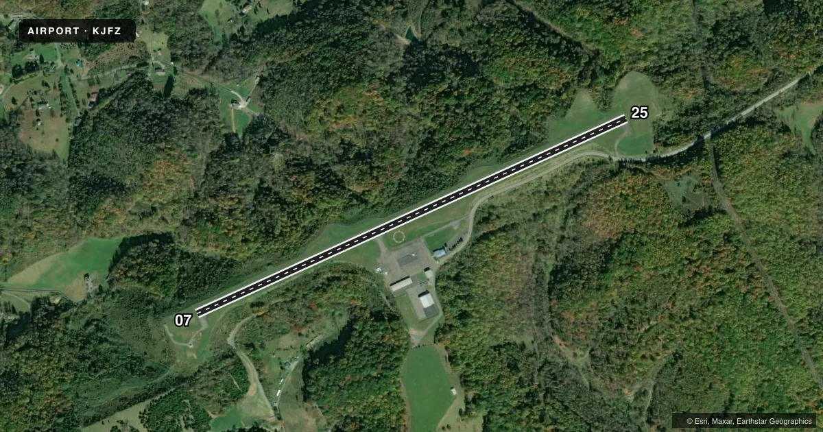
Airport sketch
Runways drawn to scale from FAA survey coordinates, rendered over satellite imagery. Not for navigation.
Approaches & charts
ILS · 1
Services on the field
Fuel grades, oxygen, maintenance, ramp storage and lighting — as declared to the FAA by the airport operator.
Fuel & services
- Fuel
- 100LLA+
- Other services
- RNTL
Ramp & ground
- Transient storage
- Tie-down
- Lighting schedule
- SEE RMK
- Beacon schedule
- SS-SR
- Beacon
- White / Green (civil land)(WG)
- Wind indicator
- Lighted
- Segmented circle
- Yes
Fuel & FBOs
Cheapest 100LL and Jet A on the field and nearby. Always confirm with the FBO before taxi.
Airport notes
Surface conditions, obstructions, local procedures, lighting outages and other notes published with each FAA cycle.
General notes
- GCO AVBL ON FREQ 135.075 THRU ZTL CLEARANCE DELIVERY AND DCA RADIO - INOP.
- FOR CD IF UNA VIA GCO CTC ATLANTA ARTCC AT 770-210-7692.
Lighting notes
- MIRL RWY 07/25 PRESET LOW INTST. TO INCREASE INTST & ACTVT REIL RWYS 07 & 25; PAPI RWY 07 & 25 - CTAF.
Approach & departure obstructions
- 07BRUSH 113 FT L OF CNTRLN AND OVER EMBANKMENT ADJ TO RWY.
- 07CTLNG OBSTN EXCEEDS A 45 DEG SLP.
Other notes
- 1UNATNDD NEW YEARS, THANKSGIVING, & CHRISTMAS.
- 1FOR SUN SVC, CALL APRT DURG RGLR BUS HRS TO ARNG. AFT HRS NRS LISTED ON DOOR.
VFR map & nearby airports
VFR sectional. Tap any ICAO chip to open that airport.
Key facts · KJFZ
Answer card- ICAO
- KJFZ
- Name
- TAZEWELL COUNTY
- Location
- RICHLANDS, VIRGINIA
- Elevation
- 2,653.1 ft MSL
- Traffic pattern altitude
- 3,653.1 ft MSL (1,000 AGL)
- Control tower
- Non-towered (use CTAF)
- Total runways
- 1
- Longest runway
- 07/25 · 4,299 ft
- Published ILS approaches
- 1
- Published frequencies
- 2
- Magnetic variation
- 6°
- Current flight rules
- LIFR
- Current wind
- 270° at 4 kt
- Favored runway now
- RWY 25
Tazewell County Airport sits in Richlands, Virginia. The field elevation is 2,653.1 ft MSL. It has one runway. Runway 07/25 is 4,299 ft long with asphalt pavement. There is no control tower. CTAF and UNICOM are both 123.05.
One ILS approach is published for runway 25. The runway lighting is medium intensity. It starts at low intensity. Use the CTAF to raise intensity. That also activates the runway end identifier lights on 07 and 25. It also turns on the PAPI for both ends. The published pattern altitude is not listed. Use 1,000 ft AGL as the standard pattern reference unless the current Chart Supplement says otherwise.
Tazewell County Airport has one on-field FBO. Tazewell County Airport carries 100LL and Jet A Prist. Call (276) 963-4509 for current service details. The field also has a ground communications outlet on 135.075 through ZTL clearance delivery. DCA radio is inoperative. If you need clearance delivery another way, Atlanta ARTCC is listed at 770-210-7692.
First-time pilots should pay attention to the terrain and elevation. This is a high field for light piston work. Runway 07 has published brush near the left side of the centerline. The controlling obstruction near 07 exceeds a 45 degree slope. Sunset service is by arrangement during business hours. The airport is unattended on New Years, Thanksgiving and Christmas.