METAR & TAF 6A4
6A4 does not publish a METAR.
Showing the nearest reporting station: KVJI (VIRGINIA HIGHLANDS) · 19.0 NM away. Conditions at 6A4 may differ.
METAR · KVJI
Observed 11:15Z
KVJI 271115Z AUTO 00000KT M1/4SM FG VV000 20/20 A2997 RMK AO2
- Wind
- 000° @ 0 kt
- Visibility
- —
- Temp / Dew
- 20°C / 20°C
- Altimeter
- 29.97 inHg
- Clouds
- VV
- Density alt
- 3,317 ft
- Ceiling
- 0 ft AGL
- Rules
- LIFR
Airport info & contacts
Manager on record, flight service, ARTCC, attendance schedule and pattern altitude — published by the FAA and refreshed every 28 days.
Location
- From city
- 4 NM S
- VFR sectional
- CINCINNATI
- ARTCC
- ZTL · ATLANTA
- NOTAM facility
- BNA (NOTAM-D)
Airport manager
- Name
- DAVE GARRIS
- Phone
- 423-727-1223
- Address
- 611 AIRPORT ROAD, MOUNTAIN CITY TN 37683
Flight service · Hours
- FSS BNA
- NASHVILLE1-800-WX-BRIEF
- Attendance
- 0900-1800
Frequencies
Tap any row to copy the frequency to your clipboard.
Runways & pattern
Full pagePattern entry · RWY 07
RIGHT TRAFFICRunway end performance
| End | TORA | TODA | ASDA | LDA | VGSI | Approach lights | Obstruction |
|---|---|---|---|---|---|---|---|
| 07 | — | — | — | — | PAPI 2-box left(4°) | — | 34', tree, 784' from thr, 193' R of cntrln, slope 17 |
| 25 | — | — | — | — | PAPI 2-box left(4°) | — | 97', tree, 1797' from thr, 423' R of cntrln, slope 16 |
Declared distances in feet. TORA = takeoff run available, TODA = takeoff distance, ASDA = accelerate-stop, LDA = landing distance.
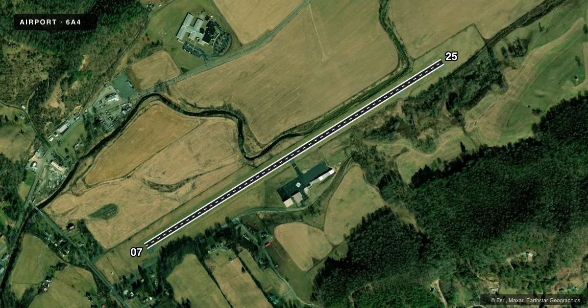
Airport sketch
Runways drawn to scale from FAA survey coordinates, rendered over satellite imagery. Not for navigation.
Approaches & charts
Services on the field
Fuel grades, oxygen, maintenance, ramp storage and lighting — as declared to the FAA by the airport operator.
Fuel & services
- Fuel
- 100LLA+
- Airframe repair
- Major
- Power plant repair
- Major
- Other services
- AVNCS,GLD,INSTR,PAJA,RNTL
Ramp & ground
- Transient storage
- Tie-down
- Hangar
- Landing fee
- No fee published
- Customs
- Not available
- Lighting schedule
- SEE RMK
- Wind indicator
- Lighted
- Segmented circle
- Yes
Fuel & FBOs
Cheapest 100LL and Jet A on the field and nearby. Always confirm with the FBO before taxi.
Airport notes
Surface conditions, obstructions, local procedures, lighting outages and other notes published with each FAA cycle.
General notes
- MT TRRN & HIGH PEAKS ALL QUADS; TSNT NIGHT OPS NOT RCMDD.
- DEER & BIRDS INVOF ARPT.
- COLD TEMPERATURE AIRPORT. ALTITUDE CORRECTION REQUIRED AT OR BELOW -9C.
- FOR CD CTC ATLANTA ARTCC AT 770-210-7692.
Lighting notes
- ACTVT PAPI RWY 07 & 25; MIRL RWY 07/25 - CTAF.
Approach & departure obstructions
- 07RWY 07 PAPI DOES NOT PRVD OBSTN CLNC BYD 1.4 NM FM THR. PAPI RWY 07 UNUSBL BYD 5 DEGS LEFT OF CNTRLN.
- 25PAPI RWY 25 DOES NOT PRVD OBSTN CLNC BYD 1.4 NM FM THR. RWY 25 PAPI UNUSBL BYD 8 DEGS LEFT OF CNTRLN.
Other notes
- VFR OPERNS ONLY.
- 1AFT HR & SVC - AMGR.
- AVNCSDYNON ONLY.
VFR map & nearby airports
VFR sectional. Tap any ICAO chip to open that airport.
Key facts · 6A4
Answer card- ICAO
- 6A4
- Name
- JOHNSON COUNTY
- Location
- MOUNTAIN CITY, TENNESSEE
- Elevation
- 2,241.1 ft MSL
- Traffic pattern altitude
- 3,241.1 ft MSL (1,000 AGL)
- Control tower
- Non-towered (use CTAF)
- Total runways
- 1
- Longest runway
- 07/25 · 4,498 ft
- Published ILS approaches
- 0
- Published frequencies
- 4
- Magnetic variation
- 7°
- Current flight rules
- LIFR
- Current wind
- 000° at 0 kt
- Favored runway now
- –
Johnson County Airport (6A4) is in Mountain City, Tennessee. The field elevation is 2,241.1 ft MSL. It has one runway, 07/25, which is 4,498 ft long. The airport is not towered. CTAF and UNICOM are both 122.7. Approach and departure service is on 134.425 and 349.0 with Tri City. No ILS approaches are published, so plan for VFR operations only.
Pattern altitude is not published. Use the standard 1,000 ft AGL for light piston aircraft unless current local guidance says otherwise. Doe Mountain Aviation Services is on the field. It carries 100LL and Jet A. Call (423) 727-1223 for current service details before you go.
The Chart Supplement remarks matter here. This is a cold temperature airport, so altitude correction is required at or below minus 9 degrees Celsius. Mountainous terrain and high peaks are present in all quadrants. Night transient operations are not recommended. Runway 07 and 25 have medium intensity runway lights and PAPI. The PAPI on 07 is not usable beyond 5 degrees left of centerline. The PAPI on 25 is not usable beyond 8 degrees left of centerline. Deer and birds are also reported in the area. For clearance delivery, contact Atlanta Center at 770-210-7692. After hours and service are available through the airport manager.