METAR & TAF 0A9
Current METAR
Observed 12:55Z
K0A9 271255Z AUTO RMK AO2 PNO PWINO
- Wind
- Calm
- Visibility
- —
- Temp / Dew
- —
- Altimeter
- —
- Clouds
- Clear
- Density alt
- —
- Ceiling
- Unlimited
- Rules
- VFR
Airport info & contacts
Manager on record, flight service, ARTCC, attendance schedule and pattern altitude — published by the FAA and refreshed every 28 days.
Location
- From city
- 3 NM NE
- VFR sectional
- CINCINNATI
- ARTCC
- ZTL · ATLANTA
- NOTAM facility
- BNA (NOTAM-D)
Airport manager
- Name
- DAN COGAN
- Phone
- 423-543-2801
- Address
- 415 HIGHWAY 91, ELIZABETHTON TN 37643
Flight service · Hours
- FSS BNA
- NASHVILLE1-800-WX-BRIEF
- Attendance
- APR-OCT · 0730-1930
- NOV-MAR · 0800-1700
Frequencies
Tap any row to copy the frequency to your clipboard.
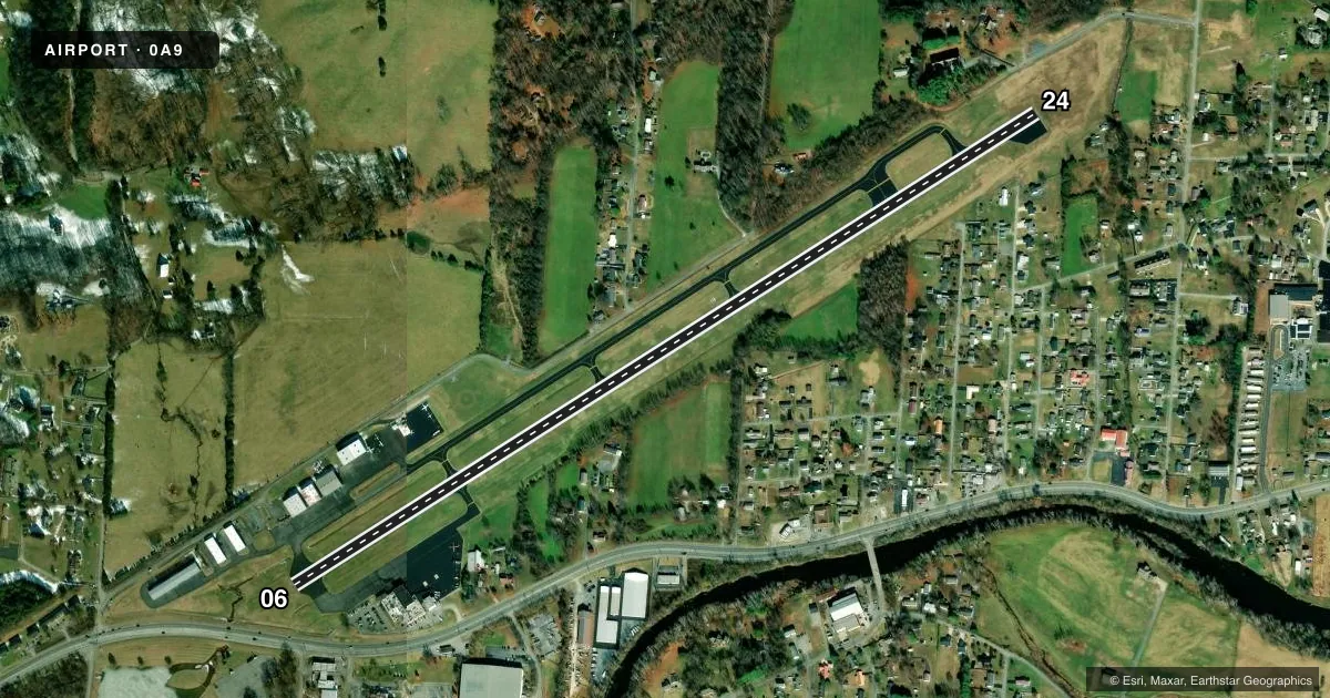
Runways & pattern
Full pagePattern entry · RWY 06
RIGHT TRAFFICRunway end performance
| End | TORA | TODA | ASDA | LDA | VGSI | Approach lights | Obstruction |
|---|---|---|---|---|---|---|---|
| 06 | 5,001' | 5,001' | 5,001' | 4,904' | S2L 2-box left(3.75°) | — | 21', tree, 840' from thr, 6' R of cntrln, slope 30 |
| 24 | 5,001' | 5,001' | 5,001' | 4,099' | — | — | 156', tree, 3108' from thr, 166' R of cntrln, slope 18 |
Declared distances in feet. TORA = takeoff run available, TODA = takeoff distance, ASDA = accelerate-stop, LDA = landing distance.
Airport sketch
Runways drawn to scale from FAA survey coordinates, rendered over satellite imagery. Not for navigation.
Approaches & charts
Services on the field
Fuel grades, oxygen, maintenance, ramp storage and lighting — as declared to the FAA by the airport operator.
Fuel & services
- Fuel
- 100LLA
- Other services
- INSTR,RNTL
Ramp & ground
- Transient storage
- Tie-down
- Hangar
- Landing fee
- No fee published
- Customs
- Not available
- Lighting schedule
- SEE RMK
- Wind indicator
- Yes
- Segmented circle
- No
Fuel & FBOs
Cheapest 100LL and Jet A on the field and nearby. Always confirm with the FBO before taxi.
Airport notes
Surface conditions, obstructions, local procedures, lighting outages and other notes published with each FAA cycle.
General notes
- COLD TEMPERATURE AIRPORT. ALTITUDE CORRECTION REQUIRED AT OR BELOW -10C.
- FOR CD CTC ATLANTA ARTCC AT 770-210-7692.
Lighting notes
- ACTVT REIL RWY 06 - CTAF. LIRL RWY 6/24 PPR - AMGR.
Runway surface & condition
- 06/24NSTD
Approach & departure obstructions
- 24DALGT OPS ONLY. HIGH PERF DEP MNTN RWY HDG UNTIL 2600 FT MSL.
- 06APCH SLOPE 27:1 TO DTHR.
Other notes
- THIS AIRPORT HAS BEEN SURVEYED BY THE NATIONAL GEODETIC SURVEY.
VFR map & nearby airports
VFR sectional. Tap any ICAO chip to open that airport.
Key facts · 0A9
Answer card- ICAO
- 0A9
- Name
- WILLIAM B GREENE JR RGNL
- Location
- ELIZABETHTON, TENNESSEE
- Elevation
- 1,592.5 ft MSL
- Traffic pattern altitude
- 2,592.5 ft MSL (1,000 AGL)
- Control tower
- Non-towered (use CTAF)
- Total runways
- 1
- Longest runway
- 06/24 · 5,001 ft
- Published ILS approaches
- 0
- Published frequencies
- 5
- Magnetic variation
- 6°
- Current flight rules
- VFR
- Current wind
- Calm / unavailable
- Favored runway now
- –
William B Greene Jr Rgnl Airport (0A9) sits in Elizabethton, Tennessee. Field elevation is 1,592.5 ft MSL. The airport has one runway, 06/24, which is 5,001 ft long. There is no control tower. No ILS approaches are published here.
Pattern altitude is not published. Use the standard 1,000 ft AGL for light piston operations unless the current Chart Supplement says otherwise. That puts the traffic pattern at about 2,592.5 ft MSL based on the listed field elevation. The airport is served by William B. Greene Jr. Regional Airport on the field. It carries AVGAS 100LL and Jet A PRIST. Call (423) 543-2801 for current service details.
A few remarks matter for planning. Operations are daylight only. Runway lighting is nonstandard. Runway end identifier lights on runway 06 are activated through CTAF. Low intensity runway lights on 06 and 24 are available with prior permission from the airport manager. High performance departures should hold runway heading until 2,600 ft MSL. This field is also a cold temperature airport. Use the required altitude correction at or below minus 10 degrees Celsius. If you need a clearance, contact Atlanta ARTCC for delivery. The runway 06 approach slope has a noted obstruction issue near the displaced threshold, so brief that side carefully before arrival.