METAR & TAF KGCY
Current METAR
Observed 16:35Z
KGCY 271635Z AUTO 28005KT 10SM 27/22 A2998 RMK A01
- Wind
- 280° @ 5 kt
- Visibility
- 10 SM
- Temp / Dew
- 27°C / 22°C
- Altimeter
- 29.98 inHg
- Clouds
- Clear
- Density alt
- 3,359 ft
- Ceiling
- Unlimited
- Rules
- VFR
Airport info & contacts
Manager on record, flight service, ARTCC, attendance schedule and pattern altitude — published by the FAA and refreshed every 28 days.
Location
- From city
- 2 NM N
- VFR sectional
- CINCINNATI
- ARTCC
- ZTL · ATLANTA
- NOTAM facility
- BNA (NOTAM-D)
Airport manager
- Name
- ANGELA ALLEY
- Phone
- 423-677-5757
- Address
- 246 AIRPORT ROAD, GREENEVILLE TN 37745
Flight service · Hours
- FSS BNA
- NASHVILLE1-800-WX-BRIEF
- Attendance
- OCT 1 - APR 30 · 0800 - 1730
- MAY 1 - SEP 30 · 0800 - 1830
Frequencies
Tap any row to copy the frequency to your clipboard.
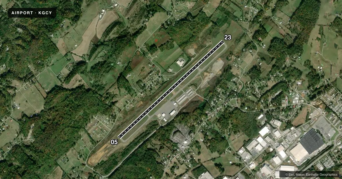
Runways & pattern
Full pagePattern entry · RWY 23
RIGHT TRAFFICRunway end performance
| End | TORA | TODA | ASDA | LDA | VGSI | Approach lights | Obstruction |
|---|---|---|---|---|---|---|---|
| 05 | — | — | — | — | PAPI 2-box left(3°) | — | — |
| 23 | — | — | — | — | PAPI 2-box left(4°) | — | 105', tree, 1642' from thr, 402' R of cntrln, slope 13 |
Declared distances in feet. TORA = takeoff run available, TODA = takeoff distance, ASDA = accelerate-stop, LDA = landing distance.
Airport sketch
Runways drawn to scale from FAA survey coordinates, rendered over satellite imagery. Not for navigation.
Approaches & charts
Services on the field
Fuel grades, oxygen, maintenance, ramp storage and lighting — as declared to the FAA by the airport operator.
Fuel & services
- Fuel
- 100LLA+
- Oxygen (bulk)
- Low pressure
- Airframe repair
- Minor
- Power plant repair
- Minor
- Other services
- AFRT,AMB,CHTR,INSTR,RNTL
Ramp & ground
- Transient storage
- Tie-down
- Hangar
- Landing fee
- No fee published
- Customs
- Not available
- Beacon schedule
- SS-SR
- Beacon
- White / Green (civil land)(WG)
- Wind indicator
- Yes
- Segmented circle
- No
Fuel & FBOs
Cheapest 100LL and Jet A on the field and nearby. Always confirm with the FBO before taxi.
Airport notes
Surface conditions, obstructions, local procedures, lighting outages and other notes published with each FAA cycle.
General notes
- PAEW ADJ RWY & TWY.
- FOR CD CTC ATLANTA ARTCC AT 770-210-7692.
Approach & departure obstructions
- 23CALM WIND RWY.
VFR map & nearby airports
VFR sectional. Tap any ICAO chip to open that airport.
Key facts · KGCY
Answer card- ICAO
- KGCY
- Name
- GREENEVILLE MUNI
- Location
- GREENEVILLE, TENNESSEE
- Elevation
- 1,607.8 ft MSL
- Traffic pattern altitude
- 2,607.8 ft MSL (1,000 AGL)
- Control tower
- Non-towered (use CTAF)
- Total runways
- 1
- Longest runway
- 05/23 · 6,301 ft
- Published ILS approaches
- 0
- Published frequencies
- 4
- Magnetic variation
- 7°
- Current flight rules
- VFR
- Current wind
- 280° at 5 kt
- Favored runway now
- RWY 23
Greeneville Muni sits in Greeneville, Tennessee. Field elevation is 1,607.8 ft MSL. The airport has one runway. Runway 05/23 is 6,301 ft long with asphalt pavement. The field is non-towered. CTAF and UNICOM are both 122.7. Approach and departure service is handled by TRI CITY on 128.05 and 317.5.
No ILS approaches are published here. Pattern altitude is not published, so use the standard 1,000 ft AGL for light piston operations unless the current FAA Chart Supplement says otherwise. That puts the pattern at about 2,608 ft MSL based on the listed field elevation. Verify the current published traffic pattern before you fly it.
Greeneville Municipal Airport is on the field. It carries 100LL and Jet A Prist. For clearance delivery, contact Atlanta ARTCC at 770-210-7692. Published remarks also note paved areas beside the runway and taxiway. Runway 23 is the calm wind runway. The elevation is high enough to pay attention to performance, especially on warm days. Check density altitude before departure. If you are new to the airport, brief the non-towered pattern, the approach frequencies and the runway 23 calm wind note before you taxi.