METAR & TAF 3A2
3A2 does not publish a METAR.
Showing the nearest reporting station: KMOR (MOORE-MURRELL) · 16.3 NM away. Conditions at 3A2 may differ.
METAR · KMOR
Observed 12:55Z
KMOR 271255Z AUTO 00000KT 8SM OVC040 23/23 A2996 RMK A01
- Wind
- 000° @ 0 kt
- Visibility
- 8 SM
- Temp / Dew
- 23°C / 23°C
- Altimeter
- 29.96 inHg
- Clouds
- OVC
- Density alt
- 2,372 ft
- Ceiling
- 4,000 ft AGL
- Rules
- VFR
Airport info & contacts
Manager on record, flight service, ARTCC, attendance schedule and pattern altitude — published by the FAA and refreshed every 28 days.
Location
- From city
- 3 NM SE
- VFR sectional
- CINCINNATI
- ARTCC
- ZTL · ATLANTA
- NOTAM facility
- BNA (NOTAM-D)
Airport manager
- Name
- JOSH OVERTON
- Phone
- 865-567-4348
- Address
- 380 AIRPORT LANE, TAZEWELL TN 37879
Flight service · Hours
- FSS BNA
- NASHVILLE1-800-WX-BRIEF
- Attendance
- 0800-1600
Frequencies
Tap any row to copy the frequency to your clipboard.
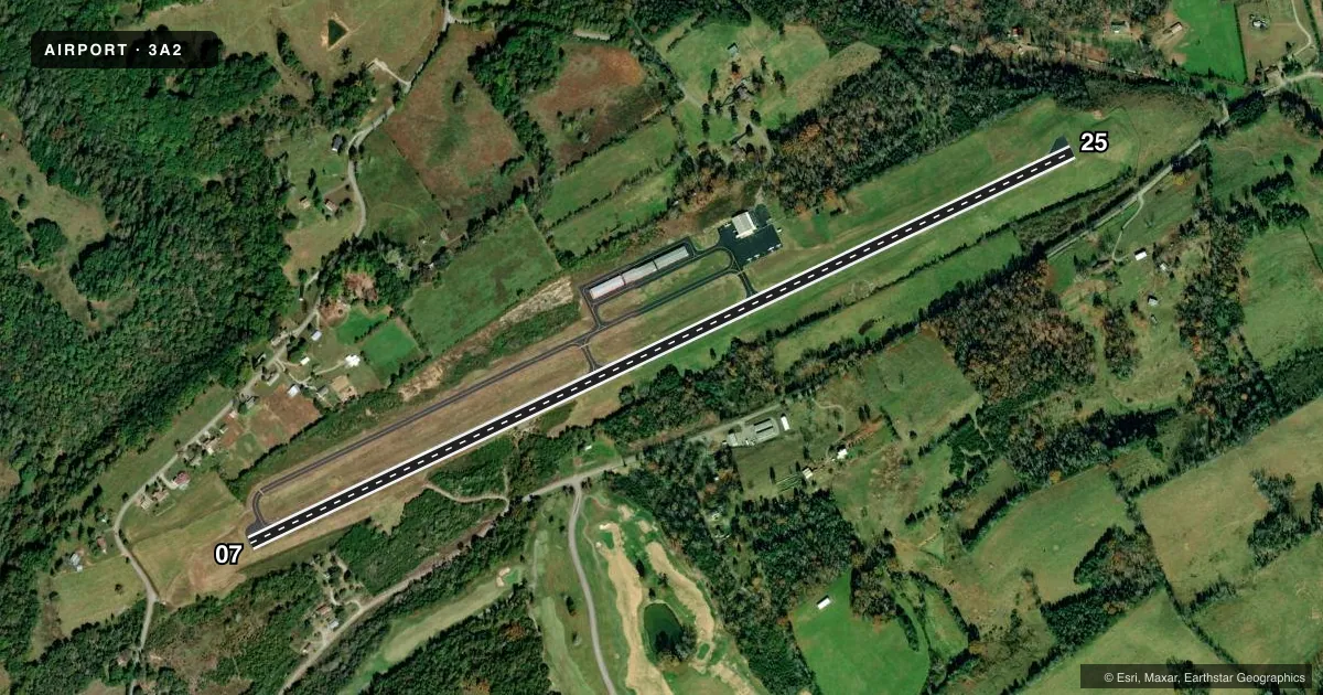
Runways & pattern
Full pagePattern entry · RWY 07
LEFT TRAFFICRunway end performance
| End | TORA | TODA | ASDA | LDA | VGSI | Approach lights | Obstruction |
|---|---|---|---|---|---|---|---|
| 07 | — | — | — | — | PAPI 2-box left(3.5°) | — | 29', trees, 794' from thr, 59' R of cntrln, slope 20 |
| 25 | — | — | — | — | PAPI 2-box left | — | 148', tree, 4300' from thr, 881' R of cntrln, slope 27 |
Declared distances in feet. TORA = takeoff run available, TODA = takeoff distance, ASDA = accelerate-stop, LDA = landing distance.
Airport sketch
Runways drawn to scale from FAA survey coordinates, rendered over satellite imagery. Not for navigation.
Approaches & charts
Services on the field
Fuel grades, oxygen, maintenance, ramp storage and lighting — as declared to the FAA by the airport operator.
Fuel & services
- Fuel
- 100LL
- Airframe repair
- Major
- Power plant repair
- Major
- Other services
- INSTR,RNTL
Ramp & ground
- Transient storage
- Tie-down
- Landing fee
- No fee published
- Customs
- Not available
- Lighting schedule
- SEE RMK
- Beacon schedule
- SS-SR
- Beacon
- White / Green (civil land)(WG)
- Wind indicator
- Lighted
- Segmented circle
- Yes
Fuel & FBOs
Cheapest 100LL and Jet A on the field and nearby. Always confirm with the FBO before taxi.
Airport notes
Surface conditions, obstructions, local procedures, lighting outages and other notes published with each FAA cycle.
General notes
- DEER ON & INVOF ARPT.
- FOR CD CTC ATLANTA ARTCC AT 770-210-7692.
Lighting notes
- ACTVT PAPI RWY 07 & 25 - CTAF.
Other notes
- VFR OPNS ONLY
- 3AFT HR - AMGR.
VFR map & nearby airports
VFR sectional. Tap any ICAO chip to open that airport.
Key facts · 3A2
Answer card- ICAO
- 3A2
- Name
- THE NEW TAZEWELL/WAYNE COFFEY MUNI
- Location
- TAZEWELL, TENNESSEE
- Elevation
- 1,178.8 ft MSL
- Traffic pattern altitude
- 2,178.8 ft MSL (1,000 AGL)
- Control tower
- Non-towered (use CTAF)
- Total runways
- 1
- Longest runway
- 07/25 · 5,208 ft
- Published ILS approaches
- 0
- Published frequencies
- 1
- Magnetic variation
- 5°
- Current flight rules
- VFR
- Current wind
- 000° at 0 kt
- Favored runway now
- –
New Tazewell Muni sits in Tazewell, Tennessee. The field elevation is 1,178.8 ft MSL. It has one runway. Runway 07/25 is 5,208 ft long and paved with asphalt. This is a non-towered field. CTAF is 122.9. No ILS approaches are published here. Pattern altitude is not published. Use the standard 1,000 ft AGL pattern unless the current Chart Supplement says otherwise.
The on-field FBO is New Tazewell Municipal Airport. It carries AVGAS 100LL. Call (423) 626-5242 for current service details before you go. Published remarks say the PAPI is active on both runway ends and is controlled by CTAF. The field is VFR only. Deer are on and near the airport, so keep a sharp scan on taxi, takeoff and landing.
For clearance delivery, contact Atlanta ARTCC at 770-210-7692. After hours, contact the airport manager. With no tower and no published ILS, this is a simple VFR stop. The runway length is workable for light piston traffic. Watch density altitude on warm days at this elevation. Check the current FAA Chart Supplement before flight for any changes to remarks or local procedures.