METAR & TAF KDKX
Current METAR
Observed 12:50Z
KDKX 271250Z AUTO 00000KT 8SM CLR 23/23 A2994 RMK A01
- Wind
- 000° @ 0 kt
- Visibility
- 8 SM
- Temp / Dew
- 23°C / 23°C
- Altimeter
- 29.94 inHg
- Clouds
- CLR
- Density alt
- 1,968 ft
- Ceiling
- Unlimited
- Rules
- VFR
Airport info & contacts
Manager on record, flight service, ARTCC, attendance schedule and pattern altitude — published by the FAA and refreshed every 28 days.
Location
- From city
- 3 NM E
- VFR sectional
- ATLANTA
- ARTCC
- ZTL · ATLANTA
- NOTAM facility
- BNA (NOTAM-D)
Airport manager
- Name
- ROB VOYLES
- Phone
- 865-342-3181
- Address
- 2701 SPENCE PLACE, KNOXVILLE TN 37920
Flight service · Hours
- FSS BNA
- NASHVILLE1-800-WX-BRIEF
- Attendance
- 0700-2200
Frequencies
Tap any row to copy the frequency to your clipboard.
Runways & pattern
Full pagePattern entry · RWY 08
LEFT TRAFFICRunway end performance
| End | TORA | TODA | ASDA | LDA | VGSI | Approach lights | Obstruction |
|---|---|---|---|---|---|---|---|
| 08 | — | — | — | — | PAPI 2-box left(3.8°) | — | 54', tree, 862' from thr, 156' R of cntrln, slope 12 |
| 26 | — | — | — | — | PAPI 2-box left(3.35°) | — | — |
Declared distances in feet. TORA = takeoff run available, TODA = takeoff distance, ASDA = accelerate-stop, LDA = landing distance.
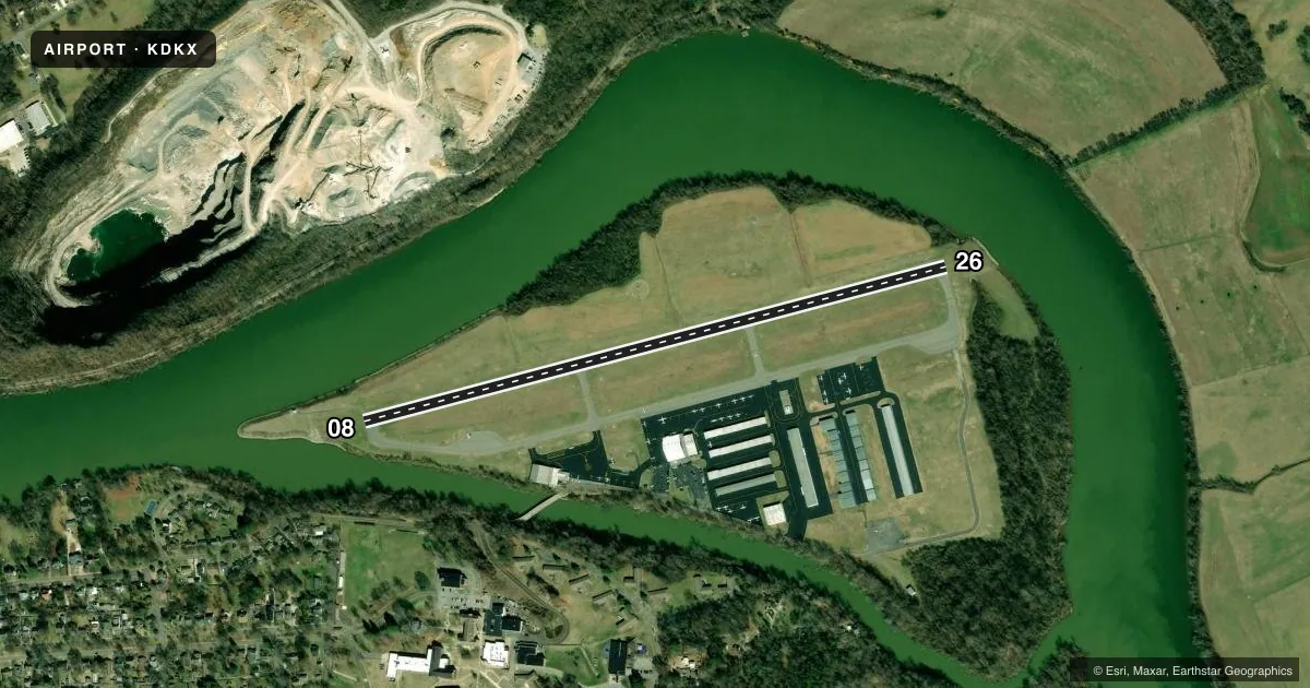
Airport sketch
Runways drawn to scale from FAA survey coordinates, rendered over satellite imagery. Not for navigation.
Approaches & charts
ILS · 1
Services on the field
Fuel grades, oxygen, maintenance, ramp storage and lighting — as declared to the FAA by the airport operator.
Fuel & services
- Fuel
- 100LLA+
- Oxygen (bottled)
- HIGH/LOW
- Oxygen (bulk)
- HIGH/LOW
- Airframe repair
- Major
- Power plant repair
- Major
- Other services
- AMB,CHTR,GLD,INSTR,RNTL,TOW
Ramp & ground
- Transient storage
- Tie-down
- Landing fee
- No fee published
- Customs
- Not available
- Lighting schedule
- SEE RMK
- Beacon schedule
- SS-SR
- Beacon
- White / Green (civil land)(WG)
- Wind indicator
- Lighted
- Segmented circle
- Yes
Fuel & FBOs
Cheapest 100LL and Jet A on the field and nearby. Always confirm with the FBO before taxi.
Airport notes
Surface conditions, obstructions, local procedures, lighting outages and other notes published with each FAA cycle.
General notes
- GEESE ON & INVOF ARPT.
- TFR OVR STADIUM 2.5 MI W; INFO & TIMES - 865-577-4461.
- FOR CD CTC KNOXVILLE APCH AT 865-980-3034; IF UNA FOR CD CTC KNOXVILLE APCH AT 865-980-3033.
Lighting notes
- REIL RWY 08 & 26; MIRL RWY 08/26 & TWY LGTS OPR DUSK-DAWN & PRESET LOW INTST; INCR INTST & ACTVT REIL RWY 08 & 26; PAPI RWY 08 & 26; MIRL RWY 08/26 - 123.075.
Fuel notes
- 100LL100LL SELF SERV H24 WITH CREDIT CARD.
Approach & departure obstructions
- 08CALM WIND RWY.
- 26NOISE SENSITIVE AREA 1 NM SW; DEP AVOID FLT OVR NBRHD.
VFR map & nearby airports
VFR sectional. Tap any ICAO chip to open that airport.
Key facts · KDKX
Answer card- ICAO
- KDKX
- Name
- KNOXVILLE DOWNTOWN ISLAND
- Location
- KNOXVILLE, TENNESSEE
- Elevation
- 833.2 ft MSL
- Traffic pattern altitude
- 1,833.2 ft MSL (1,000 AGL)
- Control tower
- Non-towered (use CTAF)
- Total runways
- 1
- Longest runway
- 08/26 · 3,499 ft
- Published ILS approaches
- 1
- Published frequencies
- 5
- Magnetic variation
- 5°
- Current flight rules
- VFR
- Current wind
- 000° at 0 kt
- Favored runway now
- –
Knoxville Downtown Island Airport sits in Knoxville, Tennessee. Field elevation is 833.2 ft MSL. The airport has one runway, 08/26, at 3,499 ft. There is no control tower. Pattern altitude is not published, so use the standard 1,000 ft AGL for light piston ops unless the current Chart Supplement says otherwise.
Runway 26 has an ILS approach. Runway 08 is listed as the calm wind runway. The field uses CTAF and UNICOM 123.075. Ground and approach services are also published. Knoxville Approach handles clearance delivery. The on-field FBO is Knoxville Downtown Island Airport. It carries 100LL and Jet A with Prist. Self-serve 100LL is available 24 hours a day with a credit card.
A few items matter for a first visit. There is a noise sensitive area 1 NM southwest of runway 26, so plan departures to avoid that neighborhood. A temporary flight restriction is published over the stadium 2.5 miles west. Geese are reported on and near the airport, so keep a sharp scan on takeoff and landing. Runway end identifier lights, medium intensity runway lights and PAPI are installed on both runway ends. Taxiway lights operate from dusk to dawn with preset low intensity. If you need current restriction details, call the airport operator or check the current FAA Chart Supplement before departure.