METAR & TAF 1A6
Current METAR
Observed 06:35Z
K1A6 270635Z AUTO 00000KT 7SM SCT029 SCT036 22/22 A2994 RMK AO2 LTG DSNT S AND SW P0001 T02220222
- Wind
- 000° @ 0 kt
- Visibility
- 7 SM
- Temp / Dew
- 22°C / 22°C
- Altimeter
- 29.94 inHg
- Clouds
- SCT
- Density alt
- 2,247 ft
- Ceiling
- Unlimited
- Rules
- VFR
Airport info & contacts
Manager on record, flight service, ARTCC, attendance schedule and pattern altitude — published by the FAA and refreshed every 28 days.
Location
- From city
- 1 NM W
- VFR sectional
- CINCINNATI
- ARTCC
- ZID · INDIANAPOLIS
- NOTAM facility
- 1A6 (NOTAM-D)
Airport manager
- Name
- GLYNNA BROWN
- Phone
- 606-242-3134
- Address
- 2116 CUMBERLAND AVE, MIDDLESBORO KY 40965
Flight service · Hours
- FSS LOU
- LOUISVILLE1-800-WX-BRIEF
- Attendance
- 0800-1700
Frequencies
Tap any row to copy the frequency to your clipboard.
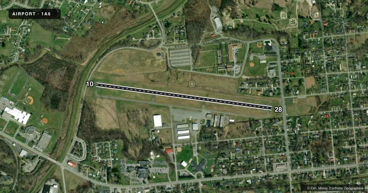
Runways & pattern
Full pagePattern entry · RWY 10
LEFT TRAFFICRunway end performance
| End | TORA | TODA | ASDA | LDA | VGSI | Approach lights | Obstruction |
|---|---|---|---|---|---|---|---|
| 10 | — | — | — | — | — | — | 92', trees, 535' from thr, 288' R of cntrln, slope 3 |
| 28 | — | — | — | — | PAPI 2-box left(3.9°) | — | 12', road, 223' from thr, 0' R of cntrln, slope 1 |
Declared distances in feet. TORA = takeoff run available, TODA = takeoff distance, ASDA = accelerate-stop, LDA = landing distance.
Airport sketch
Runways drawn to scale from FAA survey coordinates, rendered over satellite imagery. Not for navigation.
Approaches & charts
Services on the field
Fuel grades, oxygen, maintenance, ramp storage and lighting — as declared to the FAA by the airport operator.
Fuel & services
- Fuel
- 100LLA+
- Airframe repair
- Major
- Power plant repair
- Major
Ramp & ground
- Transient storage
- Tie-down
- Hangar
- Landing fee
- No fee published
- Customs
- Not available
- Lighting schedule
- SEE RMK
- Wind indicator
- Yes
- Segmented circle
- Yes
Fuel & FBOs
Cheapest 100LL and Jet A on the field and nearby. Always confirm with the FBO before taxi.
Airport notes
Surface conditions, obstructions, local procedures, lighting outages and other notes published with each FAA cycle.
General notes
- ULTRALIGHT ACT ON & INVOF ARPT.
- TREES BOTH SIDES OF RWY VIOLATE 7:1 TRANSITIONAL SFCS.
- NARROW TWYS MAY REQUIRE LG ACFT TO BACK TAXI TO/FR APRON.
- FOR CD CTC INDIANAPOLIS ARTCC AT 317-247-2411.
- COLD TEMPERATURE AIRPORT. ALTITUDE CORRECTION REQUIRED AT OR BELOW -13C.
Lighting notes
- REIL RWY 10 & 28 ON CONSLY; DALGT ONLY.
Runway surface & condition
- 10/28DALGT OPS ONLY.
Approach & departure obstructions
- 1010 FT BERM 230 FT FM RWY END 110 FT R; +4 FT FENCE 157 FT FM RWY END; +17 FT ROAD 183 FT FM RWY END.
- 10FADED & ALGAE CVRD.
- 28FADED & ALGAE CVRD.
- 10APCH RATIO 8:1 TO DTHR.
- 28APCH RATIO 25:1 TO DTHR.
- 104 FT FENCE 220 FT FM RWY END; 200 FT L & R.
Other notes
- EXISTED PRIOR TO 1959.
- 1FOR SVC - AMGR OR 606-248-3563.
- OWNER606-269-6910
VFR map & nearby airports
VFR sectional. Tap any ICAO chip to open that airport.
Key facts · 1A6
Answer card- ICAO
- 1A6
- Name
- MIDDLESBORO/BELL COUNTY
- Location
- MIDDLESBORO, KENTUCKY
- Elevation
- 1,154.3 ft MSL
- Traffic pattern altitude
- 2,154.3 ft MSL (1,000 AGL)
- Control tower
- Non-towered (use CTAF)
- Total runways
- 1
- Longest runway
- 10/28 · 3,633 ft
- Published ILS approaches
- 0
- Published frequencies
- 2
- Magnetic variation
- 5°
- Current flight rules
- VFR
- Current wind
- 000° at 0 kt
- Favored runway now
- –
Middlesboro/Bell County Airport (1A6) sits in Middlesboro, Kentucky. The field elevation is 1,154.3 ft MSL. It has one runway. Runway 10/28 is 3,633 ft long and asphalt. The airport is not towered. CTAF and UNICOM are both 122.8.
No ILS approaches are published here. The traffic pattern altitude is not published, so use the standard 1,000 ft AGL for light piston operations unless the current FAA Chart Supplement says otherwise. The on-field FBO is Middlesboro-Bell County Airport. It carries 100LL and Jet A. Call (606) 242-3134 before arrival if you need current service details.
A few operational items matter here. Daylight operations only are published for runway 10/28. Runway markings on both ends are faded and covered with algae. Ultralight activity is on and near the airport. Trees on both sides of the runway also penetrate the transitional surfaces. Runway 10 has a displaced-threshold approach slope note. Runway 28 has a similar note. The field is also listed as a cold temperature airport, so altitude correction is required at or below minus 13 degrees Celsius. Large aircraft may need to back taxi because the taxiways are narrow. If you need clearance delivery, contact Indianapolis ARTCC at 317-247-2411.