METAR & TAF 18I
18I does not publish a METAR.
Showing the nearest reporting station: KBYL (WILLIAMSBURG-WHITLEY COUNTY) · 11.0 NM away. Conditions at 18I may differ.
METAR · KBYL
Observed 06:35Z
KBYL 270635Z AUTO 00000KT 7SM CLR 21/21 A2994 RMK AO2 LTG DSNT S AND SW T02110211
- Wind
- 000° @ 0 kt
- Visibility
- 7 SM
- Temp / Dew
- 21°C / 21°C
- Altimeter
- 29.94 inHg
- Clouds
- CLR
- Density alt
- 2,394 ft
- Ceiling
- Unlimited
- Rules
- VFR
Airport info & contacts
Manager on record, flight service, ARTCC, attendance schedule and pattern altitude — published by the FAA and refreshed every 28 days.
Location
- From city
- 3 NM NE
- VFR sectional
- CINCINNATI
- ARTCC
- ZID · INDIANAPOLIS
- NOTAM facility
- LOU (NOTAM-D)
Airport manager
- Name
- BRYSON BRYANT
- Phone
- 606-516-4007
- Address
- PO BOX 1143, WHITLEY KY 42653
Flight service · Hours
- FSS LOU
- LOUISVILLE1-800-WX-BRIEF
- Attendance
- Unattended
Frequencies
Tap any row to copy the frequency to your clipboard.
Runways & pattern
Full pagePattern entry · RWY 04
LEFT TRAFFICRunway end performance
| End | TORA | TODA | ASDA | LDA | VGSI | Approach lights | Obstruction |
|---|---|---|---|---|---|---|---|
| 04 | — | — | — | — | PAPI 2-box left(4°) | — | 55', trees, 708' from thr, 239' R of cntrln, slope 9 |
| 22 | — | — | — | — | PAPI 2-box left(3°) | — | 39', trees, 536' from thr, 283' R of cntrln, slope 8 |
Declared distances in feet. TORA = takeoff run available, TODA = takeoff distance, ASDA = accelerate-stop, LDA = landing distance.
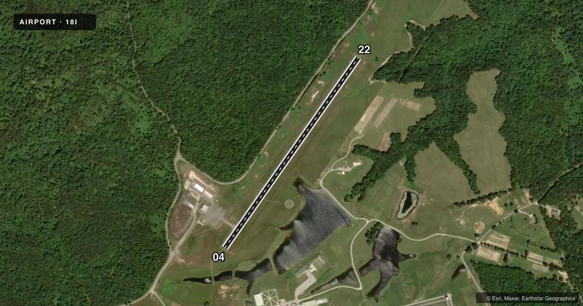
Airport sketch
Runways drawn to scale from FAA survey coordinates, rendered over satellite imagery. Not for navigation.
Approaches & charts
Services on the field
Fuel grades, oxygen, maintenance, ramp storage and lighting — as declared to the FAA by the airport operator.
Fuel & services
- Fuel
- 100LL
Ramp & ground
- Transient storage
- Tie-down
- Hangar
- Landing fee
- No fee published
- Customs
- Not available
- Lighting schedule
- SEE RMK
- Beacon schedule
- SS-SR
- Beacon
- White / Green (civil land)(WG)
- Wind indicator
- Lighted
- Segmented circle
- Yes
Fuel & FBOs
Cheapest 100LL and Jet A on the field and nearby. Always confirm with the FBO before taxi.
Airport notes
Surface conditions, obstructions, local procedures, lighting outages and other notes published with each FAA cycle.
General notes
- FOR CD CTC INDIANAPOLIS ARTCC AT 317-247-2411.
Lighting notes
- ACTVT REIL RWY 04 & 22; PAPI RWY 04 & 22; MIRL RWY 4/22 - CTAF.
Fuel notes
- 100LLTMPRYLY UNAVBL.
Other notes
- VFR USE ONLY.
VFR map & nearby airports
VFR sectional. Tap any ICAO chip to open that airport.
Key facts · 18I
Answer card- ICAO
- 18I
- Name
- MC CREARY COUNTY
- Location
- PINE KNOT, KENTUCKY
- Elevation
- 1,370.4 ft MSL
- Traffic pattern altitude
- 2,370.4 ft MSL (1,000 AGL)
- Control tower
- Non-towered (use CTAF)
- Total runways
- 1
- Longest runway
- 04/22 · 2,999 ft
- Published ILS approaches
- 0
- Published frequencies
- 2
- Magnetic variation
- 5°
- Current flight rules
- VFR
- Current wind
- 000° at 0 kt
- Favored runway now
- –
Mc Creary County Airport is in Pine Knot, Kentucky. The field elevation is 1,370.4 ft MSL. It has one runway. Runway 04/22 is 2,999 ft long with asphalt pavement. The airport is non-towered. Use CTAF 123.05 for traffic calls. The published remarks say the airport is for VFR use only. No ILS approaches are published.
The pattern altitude is not published. Plan on the standard 1,000 ft AGL for light piston traffic unless the current Chart Supplement says otherwise. The runway has medium intensity lighting. Runway end identifier lights are installed on 04 and 22. PAPI is also installed on both ends. 100LL is temporarily unavailable, so verify fuel status with the airport operator before you launch.
This is a small field with one short runway at a higher field elevation. That means performance planning matters, especially on warm days. If you need clearance delivery, the published contact is Indianapolis Center at 317-247-2411. Check the current Chart Supplement before flying in for any updates to lighting, fuel status, or local procedures.