METAR & TAF KJAU
Current METAR
Observed 04:10Z
KJAU 270410Z AUTO 00000KT 10SM FEW050 BKN100 23/23 A2993 RMK A01
- Wind
- 000° @ 0 kt
- Visibility
- 10 SM
- Temp / Dew
- 23°C / 23°C
- Altimeter
- 29.93 inHg
- Clouds
- BKN
- Density alt
- 2,411 ft
- Ceiling
- 10,000 ft AGL
- Rules
- VFR
Airport info & contacts
Manager on record, flight service, ARTCC, attendance schedule and pattern altitude — published by the FAA and refreshed every 28 days.
Location
- From city
- 1 NM E
- VFR sectional
- CINCINNATI
- ARTCC
- ZTL · ATLANTA
- NOTAM facility
- BNA (NOTAM-D)
Airport manager
- Name
- BERT LOUPE
- Phone
- 423-562-9966
- Address
- 610 MEMORIAL LANE, JACKSBORO TN 37757
Flight service · Hours
- FSS BNA
- NASHVILLE1-800-WX-BRIEF
- Attendance
- MON-FRI · 0900-1700
- SAT · 0900-1500
Frequencies
Tap any row to copy the frequency to your clipboard.
Runways & pattern
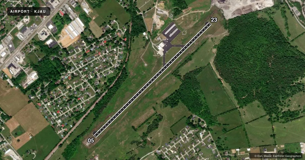
Full pagePattern entry · RWY 05
LEFT TRAFFICRunway end performance
| End | TORA | TODA | ASDA | LDA | VGSI | Approach lights | Obstruction |
|---|---|---|---|---|---|---|---|
| 05 | — | — | — | — | PAPI 2-box left(3°) | — | 28', trees, 630' from thr, 111' R of cntrln, slope 15 |
| 23 | — | — | — | — | PAPI 2-box left(3°) | — | 9', trees, 318' from thr, 81' R of cntrln, slope 13 |
Declared distances in feet. TORA = takeoff run available, TODA = takeoff distance, ASDA = accelerate-stop, LDA = landing distance.
Airport sketch
Runways drawn to scale from FAA survey coordinates, rendered over satellite imagery. Not for navigation.
Approaches & charts
Services on the field
Fuel grades, oxygen, maintenance, ramp storage and lighting — as declared to the FAA by the airport operator.
Fuel & services
- Fuel
- 100LLA
Ramp & ground
- Transient storage
- Tie-down
- Hangar
- Landing fee
- No fee published
- Customs
- Not available
- Lighting schedule
- SEE RMK
- Beacon schedule
- SS-SR
- Beacon
- White / Green (civil land)(WG)
- Wind indicator
- Lighted
- Segmented circle
- Yes
Fuel & FBOs
Cheapest 100LL and Jet A on the field and nearby. Always confirm with the FBO before taxi.
Airport notes
Surface conditions, obstructions, local procedures, lighting outages and other notes published with each FAA cycle.
General notes
- HIGH TRRN S-NE.
- DEER & COYOTE ON RWY.
- FOR CD CTC ATLANTA ARTCC AT 770-210-7692.
Lighting notes
- ACTVT REIL RWY 5 & 23; MIRL RWY 5/23 - CTAF. PAPI RWY 05 & 23 ON CONSLY.
VFR map & nearby airports
VFR sectional. Tap any ICAO chip to open that airport.
Key facts · KJAU
Answer card- ICAO
- KJAU
- Name
- COLONEL TOMMY C STINER AIRFIELD
- Location
- JACKSBORO, TENNESSEE
- Elevation
- 1,179.9 ft MSL
- Traffic pattern altitude
- 2,179.9 ft MSL (1,000 AGL)
- Control tower
- Non-towered (use CTAF)
- Total runways
- 1
- Longest runway
- 05/23 · 4,000 ft
- Published ILS approaches
- 0
- Published frequencies
- 2
- Magnetic variation
- 3°
- Current flight rules
- VFR
- Current wind
- 000° at 0 kt
- Favored runway now
- –
Colonel Tommy C Stiner Airfield is in Jacksboro, Tennessee. The field elevation is 1,179.9 ft MSL. It has one runway. Runway 05/23 is 4,000 ft long and asphalt. The airport is non-towered. CTAF and UNICOM are both 122.8.
No ILS approaches are published here. The pattern altitude is not published, so use the standard 1,000 ft AGL for light piston operations unless the current Chart Supplement says otherwise. Campbell County Aviation is on the field. It carries 100LL and Jet A. Call them at (423) 562-9966 for current service details.
A few operational notes matter here. Deer and coyotes are reported on the runway. High terrain is south to northeast, so plan your arrival and departure with that in mind. Runway end identifier lights are active on 05 and 23. Medium intensity runway lights are also on 05 and 23. They are controlled by CTAF. Precision approach path indicators are installed on both runway ends and are continuously on. For clearance delivery, contact Atlanta ARTCC at 770-210-7692. If you are new to the field, review the current Chart Supplement before you go. That is the best place to confirm any current local procedures or changes.