METAR & TAF KLOZ
Current METAR
Observed 05:53Z
KLOZ 270553Z AUTO 00000KT 10SM FEW027 SCT065 SCT110 23/22 A2997 RMK AO2 LTG DSNT S RAB24E37 SLP133 P0001 60003 T02330222 10272 20233 53001 $
- Wind
- 000° @ 0 kt
- Visibility
- 10 SM
- Temp / Dew
- 23°C / 22°C
- Altimeter
- 29.97 inHg
- Clouds
- SCT
- Density alt
- 2,401 ft
- Ceiling
- Unlimited
- Rules
- VFR
Airport info & contacts
Manager on record, flight service, ARTCC, attendance schedule and pattern altitude — published by the FAA and refreshed every 28 days.
Location
- From city
- 3 NM S
- VFR sectional
- CINCINNATI
- ARTCC
- ZID · INDIANAPOLIS
- NOTAM facility
- LOZ (NOTAM-D)
Airport manager
- Name
- MATTHEW SINGER
- Phone
- 606-878-9100
- Address
- 566 HAL ROGERS DRIVE, LONDON KY 40744
Flight service · Hours
- FSS LOU
- LOUISVILLE1-800-WX-BRIEF
- Attendance
- 0700-1900
Frequencies
Tap any row to copy the frequency to your clipboard.
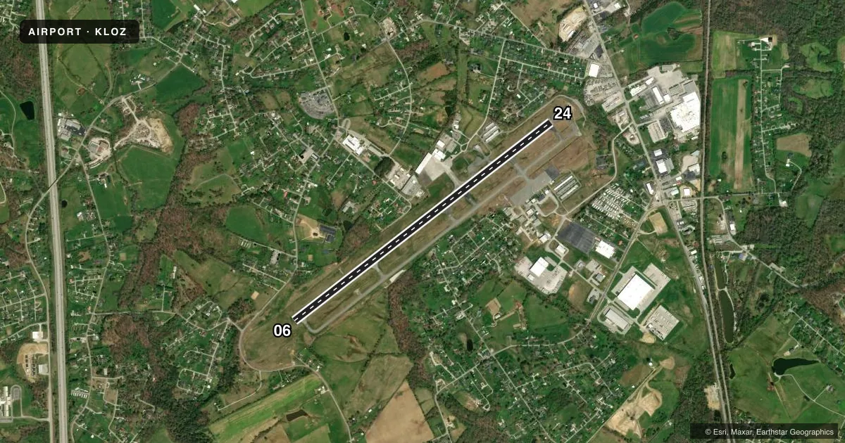
Runways & pattern
Full pagePattern entry · RWY 06
LEFT TRAFFICRunway end performance
| End | TORA | TODA | ASDA | LDA | VGSI | Approach lights | Obstruction |
|---|---|---|---|---|---|---|---|
| 06 | 5,750' | 5,750' | 5,100' | 5,000' | PAPI 4-box left(3°) | — | 56', trees, 1179' from thr, 314' R of cntrln, slope 17 |
| 24 | 5,750' | 5,750' | 5,750' | 5,200' | PAPI 4-box left(4°) | — | 33', trees, 293' from thr, 316' R of cntrln, slope 2 |
Declared distances in feet. TORA = takeoff run available, TODA = takeoff distance, ASDA = accelerate-stop, LDA = landing distance.
Airport sketch
Runways drawn to scale from FAA survey coordinates, rendered over satellite imagery. Not for navigation.
Approaches & charts
ILS · 1
Services on the field
Fuel grades, oxygen, maintenance, ramp storage and lighting — as declared to the FAA by the airport operator.
Fuel & services
- Fuel
- 100LLA+
- Airframe repair
- Major
- Power plant repair
- Major
- Other services
- AMB,CARGO,INSTR,RNTL
Ramp & ground
- Transient storage
- Tie-down
- Landing fee
- No fee published
- Customs
- Not available
- Lighting schedule
- SEE RMK
- Beacon schedule
- SS-SR
- Beacon
- White / Green (civil land)(WG)
- Wind indicator
- Yes
- Segmented circle
- Yes
Fuel & FBOs
Cheapest 100LL and Jet A on the field and nearby. Always confirm with the FBO before taxi.
Airport notes
Surface conditions, obstructions, local procedures, lighting outages and other notes published with each FAA cycle.
General notes
- FOR CD IF UNA TO CTC ON FSS FREQ, CTC INDIANAPOLIS ARTCC AT 317-247-2411.
- SCTY 606-330-5069 EMERG POC MATT 606-260-7825
Lighting notes
- ACTVT REIL RWY 06 & 24; MIRL RWY 06/24 - CTAF. PAPI RWY 06 & 24 OPR CONSLY.
Runway surface & condition
- 06/24TREES SW END OF RWY BOTH SIDES VIOLATES 7:1 TRSN SFC.
Approach & departure obstructions
- 06THR LGTS NON STD.
- 06APCH SLOPE 16:1 TO DTHR.
Other notes
- +EXISTED PRIOR TO 1959.
- MANAGERLANDLINE
VFR map & nearby airports
VFR sectional. Tap any ICAO chip to open that airport.
Key facts · KLOZ
Answer card- ICAO
- KLOZ
- Name
- LONDON/CORBIN/MAGEE
- Location
- LONDON, KENTUCKY
- Elevation
- 1,212.3 ft MSL
- Traffic pattern altitude
- 2,212.3 ft MSL (1,000 AGL)
- Control tower
- Non-towered (use CTAF)
- Total runways
- 1
- Longest runway
- 06/24 · 5,750 ft
- Published ILS approaches
- 1
- Published frequencies
- 2
- Magnetic variation
- 5°
- Current flight rules
- VFR
- Current wind
- 000° at 0 kt
- Favored runway now
- –
London/Corbin/Magee Airport sits in London, Kentucky. Field elevation is 1,212.3 ft MSL. The airport has one asphalt runway, 06/24, at 5,750 ft. There is no control tower. CTAF and UNICOM are both 123.0. One ILS approach is published for runway 06.
Pattern altitude is not published. Use the standard 1,000 ft AGL pattern for light piston traffic unless current instructions say otherwise. The field has runway lighting on 06 and 24. REIL is installed on both ends. PAPI is available on both ends and operates continuously. Threshold lights on runway 06 are non-standard. Trees at the southwest end of the runway penetrate the transitional surface. The approach to the displaced threshold on 06 has a 16 to 1 slope issue, so brief your descent and final carefully.
London-Corbin Airport is on the field. It carries AVGAS 100LL and Jet A. For clearance delivery, if Flight Service is not available, the published contact is Indianapolis ARTCC. This is a non-towered field, so expect self-announce traffic and be ready for local operations. The airport sits in a higher-elevation part of Kentucky, so performance planning still matters on warm days.