METAR & TAF KCPF
Current METAR
Observed 13:15Z
KCPF 271315Z AUTO 00000KT 3/4SM BR OVC001 20/20 A2998 RMK AO2
- Wind
- 000° @ 0 kt
- Visibility
- 0.75 SM
- Temp / Dew
- 20°C / 20°C
- Altimeter
- 29.98 inHg
- Clouds
- OVC
- Density alt
- 2,084 ft
- Ceiling
- 100 ft AGL
- Rules
- LIFR
Airport info & contacts
Manager on record, flight service, ARTCC, attendance schedule and pattern altitude — published by the FAA and refreshed every 28 days.
Location
- From city
- 10 NM NW
- VFR sectional
- CINCINNATI
- ARTCC
- ZID · INDIANAPOLIS
- NOTAM facility
- LOU (NOTAM-D)
Airport manager
- Name
- JORDYN AMUNDSEN
- Phone
- 606-275-8003
- Address
- 1300 WENDELL H. FORD TERMINAL ROAD, CHAVIES KY 41727
Flight service · Hours
- FSS LOU
- LOUISVILLE1-800-WX-BRIEF
- Attendance
- 0800-1800
Frequencies
Tap any row to copy the frequency to your clipboard.
Runways & pattern
Full pagePattern entry · RWY 14
LEFT TRAFFIC| Runway | Heading (°M) | Length | Surface | Traffic |
|---|---|---|---|---|
| 14/32 | 133° / 313° | 5,499 ft | ASPH | Standard L |
| 06/24 | 53° / 233° | 3,246 ft | ASPH | Standard L |
Runway end performance
| End | TORA | TODA | ASDA | LDA | VGSI | Approach lights | Obstruction |
|---|---|---|---|---|---|---|---|
| 14 | — | — | — | — | PAPI 4-box left(3.29°) | — | 20', hangar, 638' from thr, 487' R of cntrln, slope 21 |
| 32 | — | — | — | — | PAPI 4-box left(4.04°) | — | 22', trees, 247' from thr, 435' R of cntrln, slope 2 |
Declared distances in feet. TORA = takeoff run available, TODA = takeoff distance, ASDA = accelerate-stop, LDA = landing distance.
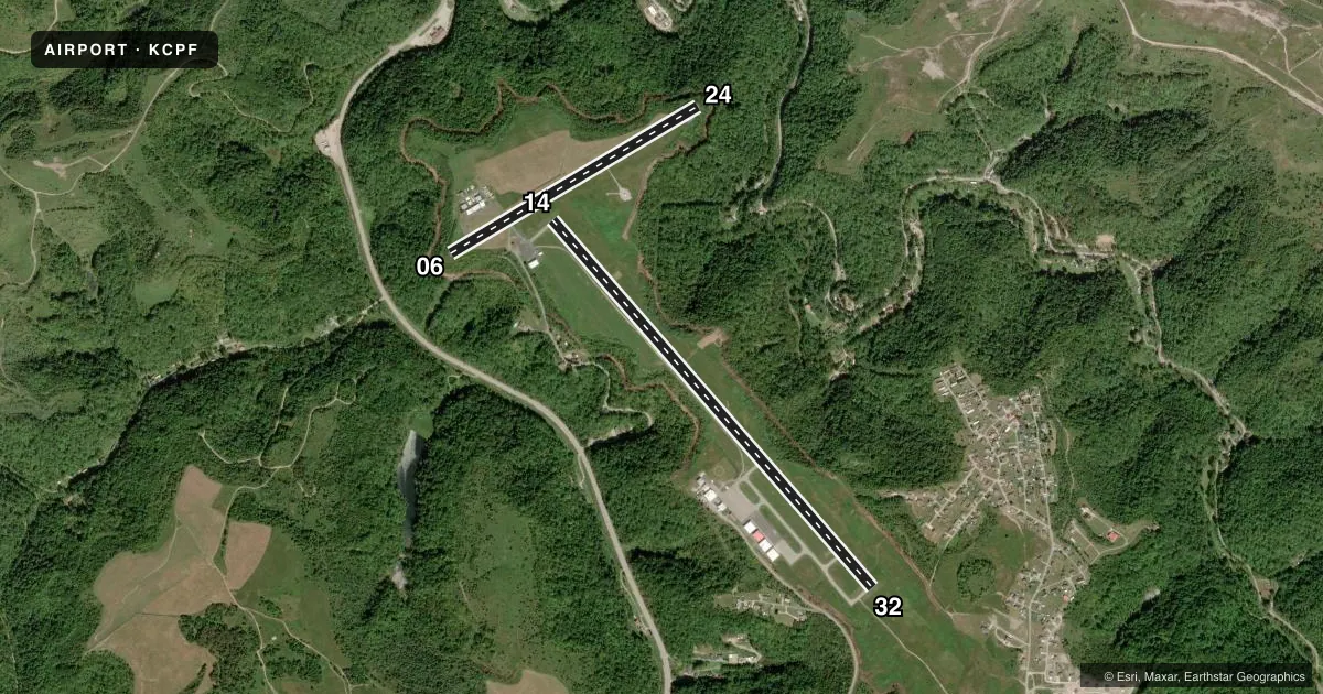
Airport sketch
Runways drawn to scale from FAA survey coordinates, rendered over satellite imagery. Not for navigation.
Approaches & charts
ILS · 1
Services on the field
Fuel grades, oxygen, maintenance, ramp storage and lighting — as declared to the FAA by the airport operator.
Fuel & services
- Fuel
- 100LLA+
- Oxygen (bulk)
- HIGH/LOW
- Airframe repair
- Minor
- Other services
- CHTR,INSTR,RNTL
Ramp & ground
- Transient storage
- Tie-down
- Hangar
- Landing fee
- Yes
- Lighting schedule
- SEE RMK
- Beacon schedule
- SS-SR
- Beacon
- White / Green (civil land)(WG)
- Wind indicator
- Lighted
- Segmented circle
- Yes
Fuel & FBOs
Cheapest 100LL and Jet A on the field and nearby. Always confirm with the FBO before taxi.
Airport notes
Surface conditions, obstructions, local procedures, lighting outages and other notes published with each FAA cycle.
General notes
- FOR CD CTC INDIANAPOLIS ARTCC AT 317-247-2411.
Lighting notes
- ACTVT REIL RWY 14 & 32; PAPI RWY 14 & 32; MIRL RWY 14/32- CTAF.
Runway surface & condition
- 06/24CLSD DLY SS-SR; BOTH RWY ENDS HAVE 300 FT DROP OFF.
Approach & departure obstructions
- 24TREES & BRUSH 25 FT FM SFC END BOTH SIDES.
- 32PAPI RWY 32 UNUSBL BYD 2.5 NM; PAPI RWY 32 UNUSBL BYD 7 DEGS RIGHT & BYD 5 DEGS LEFT OF CTNRLN.
Other notes
- RAMP FEES.
VFR map & nearby airports
VFR sectional. Tap any ICAO chip to open that airport.
Key facts · KCPF
Answer card- ICAO
- KCPF
- Name
- WENDELL H FORD
- Location
- HAZARD, KENTUCKY
- Elevation
- 1,256.8 ft MSL
- Traffic pattern altitude
- 2,256.8 ft MSL (1,000 AGL)
- Control tower
- Non-towered (use CTAF)
- Total runways
- 2
- Longest runway
- 14/32 · 5,499 ft
- Published ILS approaches
- 1
- Published frequencies
- 2
- Magnetic variation
- 6°
- Current flight rules
- LIFR
- Current wind
- 000° at 0 kt
- Favored runway now
- –
Wendell H Ford Airport sits in Hazard, Kentucky. Field elevation is 1,256.8 ft MSL. The airport has two asphalt runways. The longest is 5,499 ft on runway 14/32. There is no control tower. CTAF and UNICOM are both 122.7. The field has one ILS approach. It serves runway 14.
Pattern altitude is not published. Use standard 1,000 ft AGL for light piston planning unless the current Chart Supplement says otherwise. Triton Airways is on the field. It carries 100LL and Jet A. Call (606) 439-5140 for current service details before you go. Ramp fees apply.
This is a field where runway choice matters. Runway 06/24 is closed daily from sunset to sunrise. Both ends of 06/24 have a 300-foot drop off. Trees and brush are close to the end of runway 24. Runway 14/32 has PAPI and runway end identifier lights. The PAPI for runway 32 has limits beyond 2.5 NM. It is also unusable beyond 7 degrees right and beyond 5 degrees left of centerline. For clearance delivery, contact Indianapolis ARTCC at 317-247-2411. Check the current Chart Supplement before departure for any changes to lighting, procedures, or local restrictions.