METAR & TAF 9I3
9I3 does not publish a METAR.
Showing the nearest reporting station: KJKL (JULIAN CARROLL) · 19.5 NM away. Conditions at 9I3 may differ.
METAR · KJKL
Observed 21:53Z
KJKL 262153Z AUTO 31003KT 10SM FEW043 27/22 A2995 RMK AO2 SLP125 T02670217 $
- Wind
- 310° @ 3 kt
- Visibility
- 10 SM
- Temp / Dew
- 27°C / 22°C
- Altimeter
- 29.95 inHg
- Clouds
- FEW
- Density alt
- 2,561 ft
- Ceiling
- Unlimited
- Rules
- VFR
Airport info & contacts
Manager on record, flight service, ARTCC, attendance schedule and pattern altitude — published by the FAA and refreshed every 28 days.
Location
- From city
- 1 NM S
- VFR sectional
- CINCINNATI
- ARTCC
- ZID · INDIANAPOLIS
- NOTAM facility
- LOU (NOTAM-D)
Airport manager
- Name
- JEREMIAH MEYER
- Phone
- 606-362-6204
- Address
- 50 AIRPORT WAY, WEST LIBERTY KY 41472
Flight service · Hours
- FSS LOU
- LOUISVILLE1-800-WX-BRIEF
- Attendance
- Unattended
Frequencies
Tap any row to copy the frequency to your clipboard.
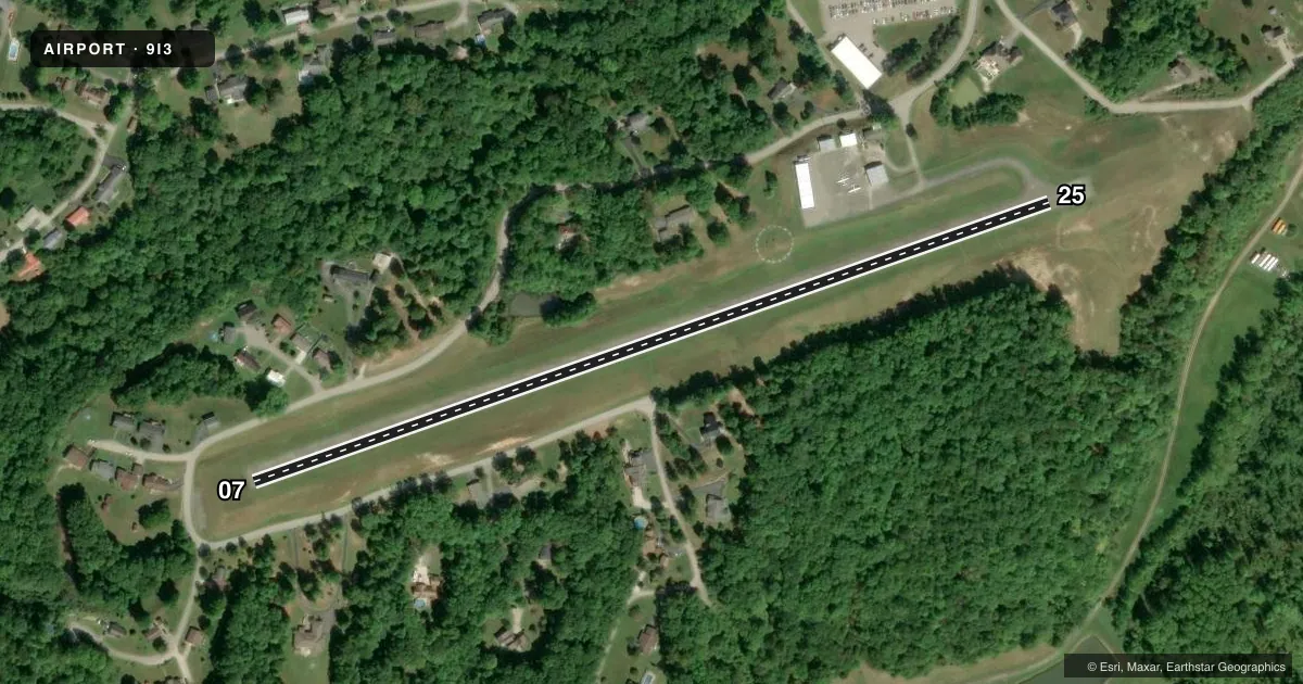
Runways & pattern
Full pagePattern entry · RWY 25
LEFT TRAFFICRunway end performance
| End | TORA | TODA | ASDA | LDA | VGSI | Approach lights | Obstruction |
|---|---|---|---|---|---|---|---|
| 07 | — | — | — | — | — | — | 25', trees, 249' from thr, 26' R of cntrln, slope 1 |
| 25 | — | — | — | — | — | — | 26', trees, 332' from thr, 135' R of cntrln, slope 5 |
Declared distances in feet. TORA = takeoff run available, TODA = takeoff distance, ASDA = accelerate-stop, LDA = landing distance.
Airport sketch
Runways drawn to scale from FAA survey coordinates, rendered over satellite imagery. Not for navigation.
Approaches & charts
Services on the field
Fuel grades, oxygen, maintenance, ramp storage and lighting — as declared to the FAA by the airport operator.
Fuel & services
- Fuel
- Not available
Ramp & ground
- Transient storage
- Tie-down
- Landing fee
- No fee published
- Customs
- Not available
- Wind indicator
- Yes
- Segmented circle
- Yes
Fuel & FBOs
Cheapest 100LL and Jet A on the field and nearby. Always confirm with the FBO before taxi.
Airport notes
Surface conditions, obstructions, local procedures, lighting outages and other notes published with each FAA cycle.
General notes
- DEER ON & INVOF ARPT.
- FOR CD CTC INDIANAPOLIS ARTCC AT 317-247-2411.
Runway surface & condition
- 07/251.5 PCT E - W DOWNSLOPE; TREES & TRRN BOTH SIDES VIOLATE 7:1 TRSN SFC.
Approach & departure obstructions
- 07FADED & ALGAE CVRD.
- 25FADED & ALGAE CVRD.
Other notes
- VFR OPS ONLY
VFR map & nearby airports
VFR sectional. Tap any ICAO chip to open that airport.
Key facts · 9I3
Answer card- ICAO
- 9I3
- Name
- WEST LIBERTY
- Location
- WEST LIBERTY, KENTUCKY
- Elevation
- 934 ft MSL
- Traffic pattern altitude
- 1,934 ft MSL (1,000 AGL)
- Control tower
- Non-towered (use CTAF)
- Total runways
- 1
- Longest runway
- 07/25 · 2,400 ft
- Published ILS approaches
- 0
- Published frequencies
- 1
- Magnetic variation
- 4°
- Current flight rules
- VFR
- Current wind
- 310° at 3 kt
- Favored runway now
- RWY 25
West Liberty Airport (9I3) sits in West Liberty, Kentucky. Field elevation is 934 ft MSL. It has one runway, 07/25, which is 2,400 ft long and asphalt. The airport is not towered. CTAF is 122.9.
No ILS approaches are published here. The published pattern altitude is not listed, so use the standard 1,000 ft AGL pattern unless current local guidance says otherwise. For this field that works out to about 1,934 ft MSL. This is a VFR-only airport. For clearance delivery, contact Indianapolis ARTCC at 317-247-2411.
The published remarks matter here. Deer are on and near the airport. Runway 07 and Runway 25 both have faded markings with algae noted. Runway 07/25 also has a 1.5 percent east to west downslope. Trees and terrain on both sides violate the 7 to 1 transition surface, so expect a tighter visual environment than a flat strip. There are no on-field FBOs listed, so verify services with the airport operator or call the field on CTAF before you go.