METAR & TAF I50
I50 does not publish a METAR.
Showing the nearest reporting station: KIOB (MOUNT STERLING/MONTGOMERY COUNTY) · 14.0 NM away. Conditions at I50 may differ.
METAR · KIOB
Observed 13:35Z
KIOB 271335Z AUTO 00000KT 10SM CLR 23/21 A3000 RMK AO2 PWINO
- Wind
- 000° @ 0 kt
- Visibility
- 10 SM
- Temp / Dew
- 23°C / 21°C
- Altimeter
- 30.00 inHg
- Clouds
- CLR
- Density alt
- 1,668 ft
- Ceiling
- Unlimited
- Rules
- VFR
Airport info & contacts
Manager on record, flight service, ARTCC, attendance schedule and pattern altitude — published by the FAA and refreshed every 28 days.
Location
- From city
- 1 NM E
- VFR sectional
- CINCINNATI
- ARTCC
- ZID · INDIANAPOLIS
- NOTAM facility
- LOU (NOTAM-D)
Airport manager
- Name
- CHARLES DONALDSON
- Phone
- 606-569-9011
- Address
- 310 AIRPORT ROAD, STANTON KY 40380
Flight service · Hours
- FSS LOU
- LOUISVILLE1-800-WX-BRIEF
- Attendance
- Unattended
Frequencies
Tap any row to copy the frequency to your clipboard.
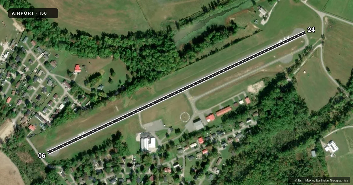
Runways & pattern
Full pagePattern entry · RWY 06
LEFT TRAFFICRunway end performance
| End | TORA | TODA | ASDA | LDA | VGSI | Approach lights | Obstruction |
|---|---|---|---|---|---|---|---|
| 06 | — | 2,890' | 2,990' | 2,460' | PAPI 2-box left(3.5°) | — | 31', trees, 278' from thr, 123' R of cntrln, slope 2 |
| 24 | — | 2,770' | 2,990' | 2,550' | — | — | 8', road, 201' from thr, 0' R of cntrln, slope 1 |
Declared distances in feet. TORA = takeoff run available, TODA = takeoff distance, ASDA = accelerate-stop, LDA = landing distance.
Airport sketch
Runways drawn to scale from FAA survey coordinates, rendered over satellite imagery. Not for navigation.
Approaches & charts
Services on the field
Fuel grades, oxygen, maintenance, ramp storage and lighting — as declared to the FAA by the airport operator.
Fuel & services
- Fuel
- 100LL
- Oxygen (bottled)
- Not available
- Oxygen (bulk)
- Not available
- Airframe repair
- Not available
- Power plant repair
- Not available
Ramp & ground
- Transient storage
- Tie-down
- Landing fee
- No fee published
- Customs
- Not available
- Lighting schedule
- SEE RMK
- Beacon schedule
- SS-SR
- Beacon
- White / Green (civil land)(WG)
- Wind indicator
- Yes
- Segmented circle
- Yes
Fuel & FBOs
Cheapest 100LL and Jet A on the field and nearby. Always confirm with the FBO before taxi.
Airport notes
Surface conditions, obstructions, local procedures, lighting outages and other notes published with each FAA cycle.
General notes
- TERMINAL ACCESS GATE CODE 0651
- FOR CD CTC LEXINGTON APCH AT 859-514-7890.
Lighting notes
- ACTVT REIL RWY 06 & 24; PAPI RWY 06; MIRL RWY 06/24 - CTAF.
Fuel notes
- 100LLFUEL AVBL 24 HR WITH CREDIT CARD.
Approach & departure obstructions
- 06APCH SLOPE 20:1 TO DSPLCD THR.
- 24TREES 1,193 FT BYD RWY, 179' RT, AND 113' ABOVE RESULTS IN APCH SLOPE OF 12:1 TO DSPLCD THR.
Other notes
- EXISTED PRIOR TO 1959.
VFR map & nearby airports
VFR sectional. Tap any ICAO chip to open that airport.
Key facts · I50
Answer card- ICAO
- I50
- Name
- STANTON
- Location
- STANTON, KENTUCKY
- Elevation
- 651.1 ft MSL
- Traffic pattern altitude
- 1,651.1 ft MSL (1,000 AGL)
- Control tower
- Non-towered (use CTAF)
- Total runways
- 1
- Longest runway
- 06/24 · 2,996 ft
- Published ILS approaches
- 0
- Published frequencies
- 2
- Magnetic variation
- 4°
- Current flight rules
- VFR
- Current wind
- 000° at 0 kt
- Favored runway now
- –
Stanton Airport (I50) sits in Stanton, Kentucky. The field elevation is 651.1 ft MSL. It has one runway. Runway 06/24 is 2,996 ft long with asphalt pavement. There is no control tower. CTAF and UNICOM are both 122.8.
No ILS approaches are published here. Pattern altitude is not published, so use the standard 1,000 ft AGL pattern unless the current Chart Supplement says otherwise. That puts the light piston pattern at about 1,651 ft MSL based on the field elevation. Runway lighting is pilot-controlled on 122.8. Runway end identifier lights are on 06 and 24. PAPI is on runway 06.
The on-field FBO is Stanton Airport. It carries AVGAS 100LL. Fuel is available 24 hours with credit card. The terminal access gate code is 0651. For clearance delivery, contact Lexington Approach at 859-514-7890.
Watch the runway environment on both ends. The published remarks call out a 20:1 approach slope to the displaced threshold on runway 06. Runway 24 has trees beyond the threshold that affect the approach path. This is a small non-towered field, so plan for self-announce traffic and verify current procedures before arrival.