METAR & TAF KRGA
Current METAR
Observed 13:15Z
KRGA 271315Z AUTO 28003KT 1/2SM FG OVC002 21/21 A2999 RMK AO2
- Wind
- 280° @ 3 kt
- Visibility
- 0.5 SM
- Temp / Dew
- 21°C / 21°C
- Altimeter
- 29.99 inHg
- Clouds
- OVC
- Density alt
- 1,876 ft
- Ceiling
- 200 ft AGL
- Rules
- LIFR
Airport info & contacts
Manager on record, flight service, ARTCC, attendance schedule and pattern altitude — published by the FAA and refreshed every 28 days.
Location
- From city
- 8 NM SW
- VFR sectional
- CINCINNATI
- ARTCC
- ZID · INDIANAPOLIS
- NOTAM facility
- LOU (NOTAM-D)
Airport manager
- Name
- JASON BONHAM
- Phone
- 859-986-3913
- Address
- 124 MADISON AIRPORT ROAD, RICHMOND KY 40475
Flight service · Hours
- FSS LOU
- LOUISVILLE1-800-WX-BRIEF
- Attendance
- MON-FRI · 0700-1800
- SAT · 0700-1800
- SUN · 0700-1800
Frequencies
Tap any row to copy the frequency to your clipboard.
Runways & pattern
Full pagePattern entry · RWY 36
LEFT TRAFFICRunway end performance
| End | TORA | TODA | ASDA | LDA | VGSI | Approach lights | Obstruction |
|---|---|---|---|---|---|---|---|
| 18 | — | — | — | — | PAPI 4-box left(3°) | — | — |
| 36 | — | — | — | — | PAPI 4-box left(3°) | — | 40', tree, 946' from thr, 324' R of cntrln, slope 18 |
Declared distances in feet. TORA = takeoff run available, TODA = takeoff distance, ASDA = accelerate-stop, LDA = landing distance.
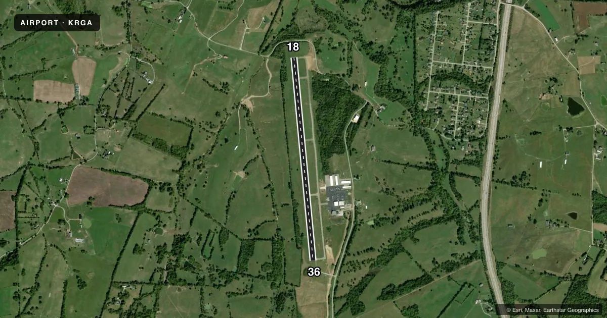
Airport sketch
Runways drawn to scale from FAA survey coordinates, rendered over satellite imagery. Not for navigation.
Approaches & charts
Services on the field
Fuel grades, oxygen, maintenance, ramp storage and lighting — as declared to the FAA by the airport operator.
Fuel & services
- Fuel
- 100LLA+
- Oxygen (bottled)
- Not available
- Oxygen (bulk)
- Not available
- Airframe repair
- Major
- Power plant repair
- Major
- Other services
- INSTR,RNTL
Ramp & ground
- Transient storage
- Tie-down
- Hangar
- Landing fee
- No fee published
- Lighting schedule
- SEE RMK
- Beacon schedule
- SS-SR
- Beacon
- White / Green (civil land)(WG)
- Wind indicator
- Lighted
- Segmented circle
- Yes
Fuel & FBOs
Cheapest 100LL and Jet A on the field and nearby. Always confirm with the FBO before taxi.
Airport notes
Surface conditions, obstructions, local procedures, lighting outages and other notes published with each FAA cycle.
General notes
- DEER AND BIRDS ON AND INVOF ARPT.
- FOR CD CTC LEXINGTON APPROACH AT 859-514-7890.
- STUDENT TRNG WI 15 NM; SFC TO 7500 FT.
Lighting notes
- ACTVT REIL RWY 18 & 36; PAPI RWY 18 & 36; MIRL RWY 18/36 - CTAF.
Fuel notes
- 100LLFUEL AVBL H24 WITH CREDIT CARD.
Other notes
- OPS CONDUCTED W OF RWY CNTRLN.
- MANAGER859-699-6031
- OWNERGEORGE WYATT
- MANAGEROFC LANDLINE.
VFR map & nearby airports
VFR sectional. Tap any ICAO chip to open that airport.
Key facts · KRGA
Answer card- ICAO
- KRGA
- Name
- CENTRAL KENTUCKY RGNL
- Location
- RICHMOND, KENTUCKY
- Elevation
- 1,002.3 ft MSL
- Traffic pattern altitude
- 2,002.3 ft MSL (1,000 AGL)
- Control tower
- Non-towered (use CTAF)
- Total runways
- 1
- Longest runway
- 18/36 · 5,001 ft
- Published ILS approaches
- 0
- Published frequencies
- 4
- Magnetic variation
- 5°
- Current flight rules
- LIFR
- Current wind
- 280° at 3 kt
- Favored runway now
- RWY 36
Central Kentucky Rgnl sits in Richmond, Kentucky. The field elevation is 1,002.3 ft MSL. It has one runway, 18/36, which is 5,001 ft long. There is no control tower. Traffic uses CTAF 122.725. UNICOM is on the same frequency. No ILS approaches are published here, so plan with the current chart and the weather on the day of flight.
The pattern altitude is not published. Use the standard 1,000 ft AGL pattern unless the current Chart Supplement or local procedure says otherwise. Lexington Approach handles clearance delivery. The published contact number is 859-514-7890. Runway end identifier lights are active on 18 and 36. Precision approach path indicators are also on both ends. Medium intensity runway lights are on runway 18/36. They are controlled by CTAF.
Eastern Kentucky University is the on-field FBO. It carries 100LL and Jet A. 100LL is available 24 hours with credit card. Student training is conducted within 15 NM from the surface to 7,500 ft. Deer and birds are reported on and near the airport. Operations are conducted west of the runway centerline. For a first-time arrival, expect a non-towered field with training traffic. Coordinate carefully on CTAF.