METAR & TAF 27K
Current METAR
Observed 11:55Z
K27K 271155Z AUTO 00000KT 6SM BR CLR 19/19 A2994 RMK AO2 T01880188 10206 20177 53014
- Wind
- 000° @ 0 kt
- Visibility
- 6 SM
- Temp / Dew
- 19°C / 19°C
- Altimeter
- 29.94 inHg
- Clouds
- CLR
- Density alt
- 1,630 ft
- Ceiling
- Unlimited
- Rules
- VFR
Airport info & contacts
Manager on record, flight service, ARTCC, attendance schedule and pattern altitude — published by the FAA and refreshed every 28 days.
Location
- From city
- 6 NM E
- VFR sectional
- CINCINNATI
- ARTCC
- ZID · INDIANAPOLIS
- NOTAM facility
- LOU (NOTAM-D)
Airport manager
- Name
- JAMES TOOLE
- Phone
- 502-863-6320
- Address
- 6206 PARIS PIKE, GEORGETOWN KY 40324
Flight service · Hours
- FSS LOU
- LOUISVILLE1-800-WX-BRIEF
- Attendance
- MON-FRI · 0800-1900
- SAT · 0800-1800
- SUN · 0900-1700
Frequencies
Tap any row to copy the frequency to your clipboard.
Runways & pattern
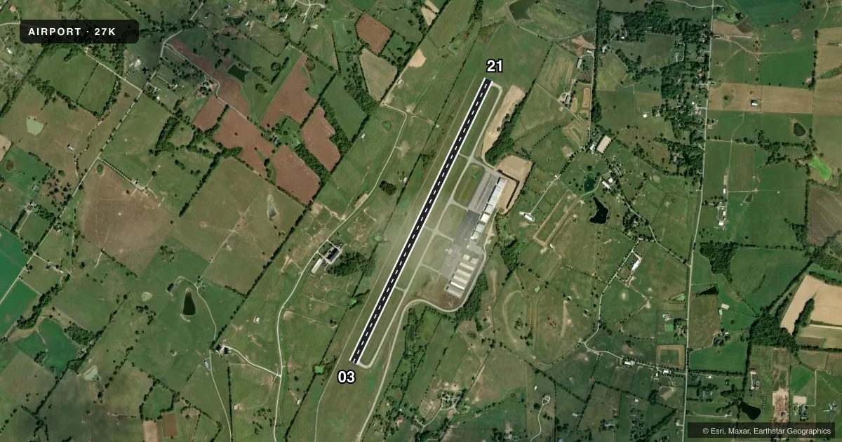
Full pagePattern entry · RWY 03
LEFT TRAFFICRunway end performance
| End | TORA | TODA | ASDA | LDA | VGSI | Approach lights | Obstruction |
|---|---|---|---|---|---|---|---|
| 03 | — | — | — | — | PAPI 2-box left(3°) | — | 16', trees, 232' from thr, 378' R of cntrln, slope 2 |
| 21 | — | — | — | — | PAPI 2-box left(3°) | — | — |
Declared distances in feet. TORA = takeoff run available, TODA = takeoff distance, ASDA = accelerate-stop, LDA = landing distance.
Airport sketch
Runways drawn to scale from FAA survey coordinates, rendered over satellite imagery. Not for navigation.
Approaches & charts
Services on the field
Fuel grades, oxygen, maintenance, ramp storage and lighting — as declared to the FAA by the airport operator.
Fuel & services
- Fuel
- 100LLA+
- Airframe repair
- Minor
- Power plant repair
- Minor
- Other services
- CARGO,CHTR,INSTR,RNTL
Ramp & ground
- Transient storage
- Tie-down
- Hangar
- Lighting schedule
- SEE RMK
- Beacon schedule
- SS-SR
- Beacon
- White / Green (civil land)(WG)
- Wind indicator
- Lighted
- Segmented circle
- Yes
Fuel & FBOs
Cheapest 100LL and Jet A on the field and nearby. Always confirm with the FBO before taxi.
Airport notes
Surface conditions, obstructions, local procedures, lighting outages and other notes published with each FAA cycle.
General notes
- FOR CD CTC LEXINGTON APCH AT 859-514-7890.
Lighting notes
- ACTVT REIL RWY 03/21; PAPI RWY 03/21; MIRL RWY 03/21; WINDSOCK - CTAF.
Fuel notes
- 100LLFUEL AVBL 24/7 WITH CC.
Other notes
- PRVDD VFR USE ONLY.
- MANAGERAFT HR - 859-608-8858.
VFR map & nearby airports
VFR sectional. Tap any ICAO chip to open that airport.
Key facts · 27K
Answer card- ICAO
- 27K
- Name
- GEORGETOWN-SCOTT COUNTY RGNL
- Location
- GEORGETOWN, KENTUCKY
- Elevation
- 947.7 ft MSL
- Traffic pattern altitude
- 1,947.7 ft MSL (1,000 AGL)
- Control tower
- Non-towered (use CTAF)
- Total runways
- 1
- Longest runway
- 03/21 · 5,498 ft
- Published ILS approaches
- 0
- Published frequencies
- 7
- Magnetic variation
- 3°
- Current flight rules
- VFR
- Current wind
- 000° at 0 kt
- Favored runway now
- –
Georgetown-Scott County Regional Airport sits in Georgetown, Kentucky at 947.7 ft MSL. It has one runway, 03/21, which is 5,498 ft long. The field is not towered. Pattern altitude is not published, so light piston traffic should plan on the standard 1,000 ft AGL unless the current Chart Supplement says otherwise. No ILS approaches are published here, so plan your arrival with the current approach chart and the Lexington frequencies if you need IFR support.
The airport is set up for VFR use. The published remarks say the field is for visual flight rules use only. Runway 03/21 has REILs, PAPI and medium intensity runway lights. Fuel is available 24 hours a day with a credit card. The on-field FBO is Georgetown-Scott County Regional Airport. It carries 100LL and Jet A Prist. Call (502) 863-6320 for current service details. For clearance delivery, contact Lexington Approach at 859-514-7890. After hours, the manager number is 859-608-8858.
For a first-time pilot, the main things to plan for are the non-towered environment. The published VFR-only note matters too. Approach support comes from Lexington. Check the current Chart Supplement for any noise or curfew restrictions before flying into the field. Use the CTAF for traffic calls. The windsock is on the CTAF frequency.