METAR & TAF KIOB
Current METAR
Observed 13:35Z
KIOB 271335Z AUTO 00000KT 10SM CLR 23/21 A3000 RMK AO2 PWINO
- Wind
- 000° @ 0 kt
- Visibility
- 10 SM
- Temp / Dew
- 23°C / 21°C
- Altimeter
- 30.00 inHg
- Clouds
- CLR
- Density alt
- 2,125 ft
- Ceiling
- Unlimited
- Rules
- VFR
Airport info & contacts
Manager on record, flight service, ARTCC, attendance schedule and pattern altitude — published by the FAA and refreshed every 28 days.
Location
- From city
- 2 NM W
- VFR sectional
- CINCINNATI
- ARTCC
- ZID · INDIANAPOLIS
- NOTAM facility
- LOU (NOTAM-D)
Airport manager
- Name
- ZACHARY HILL
- Phone
- 859-498-1000
- Address
- 709 AIRPORT ROAD, MT. STERLING KY 40353
Flight service · Hours
- FSS LOU
- LOUISVILLE1-800-WX-BRIEF
- Attendance
- 0800-1800
Frequencies
Tap any row to copy the frequency to your clipboard.
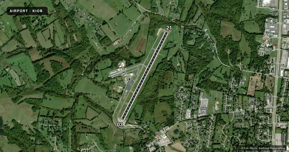
Runways & pattern
Full pagePattern entry · RWY 03
LEFT TRAFFICRunway end performance
| End | TORA | TODA | ASDA | LDA | VGSI | Approach lights | Obstruction |
|---|---|---|---|---|---|---|---|
| 03 | — | — | — | — | PAPI 4-box left(4°) | — | 78', tree, 1737' from thr, 424' R of cntrln, slope 19 |
| 21 | — | — | — | — | PAPI 4-box left(3°) | — | 49', tree, 1604' from thr, 88' R of cntrln, slope 28 |
Declared distances in feet. TORA = takeoff run available, TODA = takeoff distance, ASDA = accelerate-stop, LDA = landing distance.
Airport sketch
Runways drawn to scale from FAA survey coordinates, rendered over satellite imagery. Not for navigation.
Approaches & charts
Services on the field
Fuel grades, oxygen, maintenance, ramp storage and lighting — as declared to the FAA by the airport operator.
Fuel & services
- Fuel
- 100LLA+
- Oxygen (bottled)
- Low pressure
- Airframe repair
- Major
- Power plant repair
- Major
- Other services
- AMB,AVNCS,CHTR,INSTR,RNTL
Ramp & ground
- Transient storage
- Tie-down
- Hangar
- Landing fee
- No fee published
- Customs
- Not available
- Lighting schedule
- SEE RMK
- Beacon schedule
- SS-SR
- Beacon
- White / Green (civil land)(WG)
- Wind indicator
- Lighted
- Segmented circle
- Yes
Fuel & FBOs
Cheapest 100LL and Jet A on the field and nearby. Always confirm with the FBO before taxi.
Airport notes
Surface conditions, obstructions, local procedures, lighting outages and other notes published with each FAA cycle.
General notes
- HELI 1.1 NM & 1.9 NM NE.
- GCO AVBL ON FREQ 121.72 THRU LEX CD.
- FOR CD IF UNA VIA GCO CTC LEXINGTON APCH AT 859-514-7890.
Lighting notes
- ACTVT REIL RWY 03 & 21; PAPI RWY 03 & 21; MIRL RWY 03/21 - CTAF
Fuel notes
- 100LLFUEL AVBL 24/7 WITH CC.
Other notes
- 1SVC AFT HR - AMGR OR 859-585-9936.
- MANAGER859-585-0824
VFR map & nearby airports
VFR sectional. Tap any ICAO chip to open that airport.
Key facts · KIOB
Answer card- ICAO
- KIOB
- Name
- MOUNT STERLING/MONTGOMERY COUNTY
- Location
- MOUNT STERLING, KENTUCKY
- Elevation
- 1,019.5 ft MSL
- Traffic pattern altitude
- 2,019.5 ft MSL (1,000 AGL)
- Control tower
- Non-towered (use CTAF)
- Total runways
- 1
- Longest runway
- 03/21 · 5,000 ft
- Published ILS approaches
- 0
- Published frequencies
- 3
- Magnetic variation
- 6°
- Current flight rules
- VFR
- Current wind
- 000° at 0 kt
- Favored runway now
- –
Mount Sterling/Montgomery County Airport sits in Mount Sterling, Kentucky. The field elevation is 1,019.5 ft MSL. It has one runway, 03/21, which is 5,000 ft long. There is no control tower. Use CTAF 122.8 for local traffic. No ILS approaches are published here.
The published pattern altitude is not listed, so plan on the standard 1,000 ft AGL for light piston traffic unless the current FAA Chart Supplement says otherwise. Runway lighting is in place on 03/21. The field also has runway end identifier lights and PAPI on both ends. That helps for night work and for getting stabilized on final.
Kentucky Airmotive is on the field. It carries 100LL and Jet A. 100LL is available 24 hours a day with a credit card. If you need after-hours service, the airport manager can help or you can call the number in the Chart Supplement. Lexington Approach handles the area for clearance delivery and approach services. There is also a ground communications outlet on 121.72 through Lexington clearance delivery. Watch for helicopter traffic northeast of the airport. For any current noise, curfew, or local operating notes, check the current FAA Chart Supplement before you go.