METAR & TAF KMNV
Current METAR
Observed 13:15Z
KMNV 271315Z AUTO 00000KT 7SM FEW027 SCT039 SCT044 26/26 A2994 RMK A01
- Wind
- 000° @ 0 kt
- Visibility
- 7 SM
- Temp / Dew
- 26°C / 26°C
- Altimeter
- 29.94 inHg
- Clouds
- SCT
- Density alt
- 2,574 ft
- Ceiling
- Unlimited
- Rules
- VFR
Airport info & contacts
Manager on record, flight service, ARTCC, attendance schedule and pattern altitude — published by the FAA and refreshed every 28 days.
Location
- From city
- 2 NM NW
- VFR sectional
- ATLANTA
- ARTCC
- ZTL · ATLANTA
- NOTAM facility
- BNA (NOTAM-D)
Airport manager
- Name
- TOM MCCOSH
- Phone
- 423-572-1124
- Address
- 105 COLLEGE STREET, SUITE 1, MADISONVILLE TN 37354
Flight service · Hours
- FSS BNA
- NASHVILLE1-800-WX-BRIEF
- Attendance
- 0900-1700
Frequencies
Tap any row to copy the frequency to your clipboard.
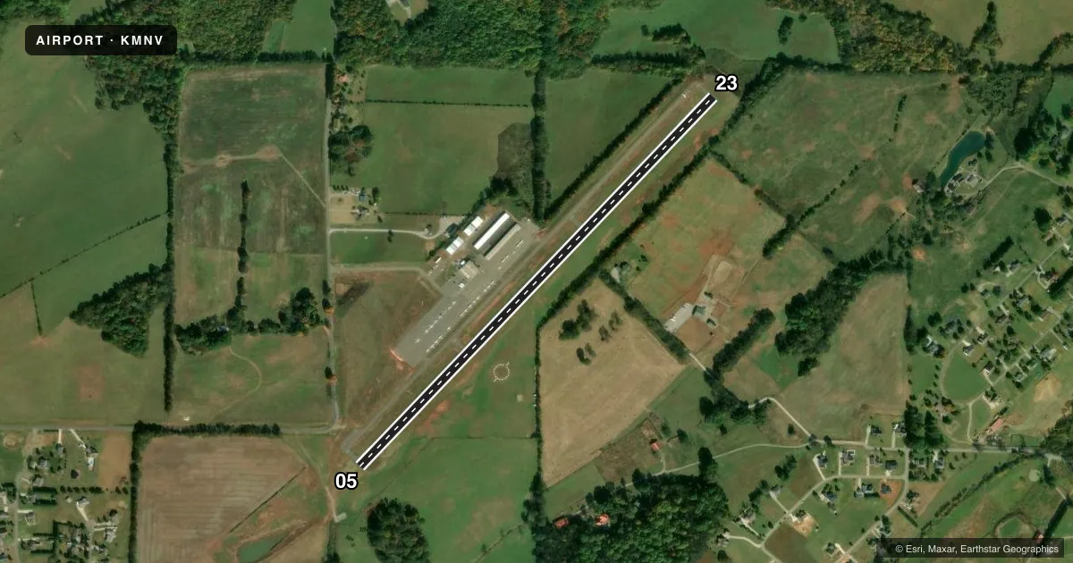
Runways & pattern
Full pagePattern entry · RWY 05
LEFT TRAFFICRunway end performance
| End | TORA | TODA | ASDA | LDA | VGSI | Approach lights | Obstruction |
|---|---|---|---|---|---|---|---|
| 05 | — | — | — | — | PAPI 2-box left(3°) | — | — |
| 23 | — | — | — | — | PAPI 2-box left(3°) | — | — |
Declared distances in feet. TORA = takeoff run available, TODA = takeoff distance, ASDA = accelerate-stop, LDA = landing distance.
Airport sketch
Runways drawn to scale from FAA survey coordinates, rendered over satellite imagery. Not for navigation.
Approaches & charts
Services on the field
Fuel grades, oxygen, maintenance, ramp storage and lighting — as declared to the FAA by the airport operator.
Fuel & services
- Fuel
- 100LLA1+
- Airframe repair
- Major
- Power plant repair
- Major
- Other services
- INSTR,RNTL
Ramp & ground
- Transient storage
- Tie-down
- Hangar
- Landing fee
- No fee published
- Customs
- Not available
- Lighting schedule
- SEE RMK
- Beacon schedule
- SS-SR
- Beacon
- White / Green (civil land)(WG)
- Wind indicator
- Lighted
- Segmented circle
- Yes
Fuel & FBOs
Cheapest 100LL and Jet A on the field and nearby. Always confirm with the FBO before taxi.
Airport notes
Surface conditions, obstructions, local procedures, lighting outages and other notes published with each FAA cycle.
General notes
- FOR CD CTC KNOXVILLE APCH AT 865-980-3034; IF UNA FOR CD CTC KNOXVILLE APCH AT 865-980-3033.
Lighting notes
- ACTVT MIRL RWY 5/23 - CTAF.
VFR map & nearby airports
VFR sectional. Tap any ICAO chip to open that airport.
Key facts · KMNV
Answer card- ICAO
- KMNV
- Name
- MONROE COUNTY
- Location
- MADISONVILLE, TENNESSEE
- Elevation
- 1,031 ft MSL
- Traffic pattern altitude
- 2,031 ft MSL (1,000 AGL)
- Control tower
- Non-towered (use CTAF)
- Total runways
- 1
- Longest runway
- 05/23 · 3,643 ft
- Published ILS approaches
- 0
- Published frequencies
- 4
- Magnetic variation
- 4°
- Current flight rules
- VFR
- Current wind
- 000° at 0 kt
- Favored runway now
- –
Monroe County Airport sits in Madisonville, Tennessee. The field elevation is 1,031 ft MSL. It has one runway, 05/23, which is 3,643 ft long and asphalt. There is no control tower. Pattern altitude is not published, so use the standard 1,000 ft AGL for light piston traffic unless the current Chart Supplement says otherwise.
No ILS approaches are published here. Plan for non-precision work or VFR arrivals. The airport uses CTAF 123.0. The runway lights on 05/23 are medium intensity. They are activated by the CTAF. That matters after sunset because you will need to key the mic to bring the lights up.
Monroe County Airport has one on-field FBO. Monroe County Airport carries 100LL and Jet A. Call (423) 420-0563 before arrival if you need current service details. For clearance delivery, contact Knoxville Approach at 865-980-3034. If that does not work, use 865-980-3033.
For a first-time arrival, the main things to brief are the non-towered environment, the single runway and the lack of published ILS. Check the current Chart Supplement for any noise or curfew restrictions before flying into the field. Also verify the current approach and departure setup with Knoxville Approach if you need IFR handling.