METAR & TAF KRHP
Current METAR
Observed 12:54Z
KRHP 271254Z AUTO 00000KT 10SM CLR 22/21 A3000 RMK AO2 T02200207
- Wind
- 000° @ 0 kt
- Visibility
- 10 SM
- Temp / Dew
- 22°C / 21°C
- Altimeter
- 30.00 inHg
- Clouds
- CLR
- Density alt
- 2,847 ft
- Ceiling
- Unlimited
- Rules
- VFR
Airport info & contacts
Manager on record, flight service, ARTCC, attendance schedule and pattern altitude — published by the FAA and refreshed every 28 days.
Location
- From city
- 2 NM W
- VFR sectional
- ATLANTA
- ARTCC
- ZTL · ATLANTA
- NOTAM facility
- RHP (NOTAM-D)
Airport manager
- Name
- CHRIS WILLIAMS
- Phone
- 828-321-5114
- Address
- 5840 AIRPORT ROAD, ANDREWS NC 28901
Flight service · Hours
- FSS RDU
- RALEIGH1-800-WX-BRIEF
- Attendance
- MON-SAT · 0900-1700
- SUN · 1200-1700
Frequencies
Tap any row to copy the frequency to your clipboard.
Runways & pattern
Full pagePattern entry · RWY 08
RIGHT TRAFFICRunway end performance
| End | TORA | TODA | ASDA | LDA | VGSI | Approach lights | Obstruction |
|---|---|---|---|---|---|---|---|
| 08 | — | — | — | — | PAPI 2-box left(4°) | — | 20', rr, 216' from thr, 246' R of cntrln, slope 0 |
| 26 | — | — | — | — | PAPI 2-box left(4°) | — | 51', trees, 1144' from thr, 92' R of cntrln, slope 18 |
Declared distances in feet. TORA = takeoff run available, TODA = takeoff distance, ASDA = accelerate-stop, LDA = landing distance.
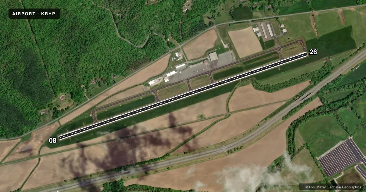
Airport sketch
Runways drawn to scale from FAA survey coordinates, rendered over satellite imagery. Not for navigation.
Approaches & charts
Services on the field
Fuel grades, oxygen, maintenance, ramp storage and lighting — as declared to the FAA by the airport operator.
Fuel & services
- Fuel
- 100LLAA1+
- Oxygen (bottled)
- Not available
- Oxygen (bulk)
- Not available
- Airframe repair
- Major
- Power plant repair
- Major
- Other services
- CHTR,INSTR,RNTL
Ramp & ground
- Transient storage
- Tie-down
- Hangar
- Landing fee
- No fee published
- Customs
- Not available
- Lighting schedule
- SEE RMK
- Beacon schedule
- SS-SR
- Beacon
- White / Green (civil land)(WG)
- Wind indicator
- Lighted
- Segmented circle
- Yes
Fuel & FBOs
Cheapest 100LL and Jet A on the field and nearby. Always confirm with the FBO before taxi.
Airport notes
Surface conditions, obstructions, local procedures, lighting outages and other notes published with each FAA cycle.
General notes
- LOW FLYING MIL JET ACFT OVERFLY ARPT.
- TWY UNLGTD.
- 4-5 FT DITCH 75 FT FROM RWY CNTRLN ON BOTH SIDES.
- RWY 08 RR 390 FT RIGHT OF CNTRLN 260 FT FM THLD.
- ARPT SRNDD BY HIGH TRRN.
- RWY 08, 8 FT DROP-OFF, 108 FT FM THLD BOTH SIDES IN RWY SAFETY AREA.
- COLD TEMPERATURE AIRPORT. ALTITUDE CORRECTION REQUIRED AT OR BELOW -4C.
- FOR CD CTC ATLANTA ARTCC AT 770-210-7692.
- LIVESTOCK PASTURED INVOF ARPT.
Lighting notes
- LCTD 0.5 MI NORTH OF WEST END OF RWY 08/26.
- MIRL RWY 08/26 OPR SS-SR; TO INCR INTST - CTAF. ACTVT REIL RWY 08 - CTAF. PAPI RWY 08 & 26 OPER CONSLY, OTR TIMES - CTAF.
Fuel notes
- 100LLFUEL AVBL 24 HR WITH CREDIT CARD.
Approach & departure obstructions
- 08HAS 5 FT CROPS 0-200 FT FM END OFFSET 150 FT RIGHT OF CNTRLN AND 2 FT BRUSH 189 FT FM END OFFSET 65 FT LEFT OF CNTRLN.
- 263 FT BERM 20 FT FM THLD OFFSET 81 FT RIGHT OF CNTRLN.
- 08PAPI UNUSBL BYD 6 DEG LEFT AND 8 DEG RIGHT OF CNTRLN DUE TO TRRN.
- 26PAPI UNUSBL BYD 6 DEG RIGHT OF CNTRLN DUE TO TRRN; UNUSBL BYD 2.5 NM FM THR DUE TO TRRN.
- 08APCH RATIO 19:1 AT DSPLCD THLD DUE TO RR.
Other notes
- 3UNATNDD THANKSGIVING, CHRISTMAS AND NEW YEARS DAY.
VFR map & nearby airports
VFR sectional. Tap any ICAO chip to open that airport.
Key facts · KRHP
Answer card- ICAO
- KRHP
- Name
- WESTERN CAROLINA RGNL
- Location
- ANDREWS, NORTH CAROLINA
- Elevation
- 1,698.7 ft MSL
- Traffic pattern altitude
- 2,698.7 ft MSL (1,000 AGL)
- Control tower
- Non-towered (use CTAF)
- Total runways
- 1
- Longest runway
- 08/26 · 5,500 ft
- Published ILS approaches
- 0
- Published frequencies
- 2
- Magnetic variation
- 4°
- Current flight rules
- VFR
- Current wind
- 000° at 0 kt
- Favored runway now
- –
Western Carolina Rgnl is in Andrews, North Carolina. The field elevation is 1,698.7 ft MSL. It has one runway, 08/26, which is 5,500 ft long. There is no control tower. CTAF and UNICOM are both 122.8.
No ILS approaches are published here. Pattern altitude is not published, so use the standard 1,000 ft AGL for light piston traffic unless the current FAA Chart Supplement says otherwise. The airport sits in high terrain. That matters here. Expect density altitude to be a factor, especially on warm days and at this elevation. The airport is also a cold temperature airport. Altitude correction is required at or below minus 4 degrees Celsius.
Western Carolina Regional Airport is the on-field FBO. It carries AVGAS 100LL and Jet A Prist. Taxiways are unlighted. Runway 08 has published terrain and obstruction issues near the threshold. Runway 26 also has terrain limits on the PAPI. Low flying military jet traffic may overfly the airport. Medium intensity runway lights operate from sunset to sunrise. Use CTAF to increase intensity or to activate the runway end identifier lights on runway 08. The airport is unattended on Thanksgiving, Christmas and New Years Day. For any current operational detail not listed here, check the current FAA Chart Supplement or call the airport operator before departure.