METAR & TAF 24A
Current METAR
Observed 13:35Z
K24A 271335Z AUTO 00000KT 1/4SM FG OVC002 20/20 A3005 RMK AO2 VIS M1/4V1 LTG DSNT SE AND S T02010200
- Wind
- 000° @ 0 kt
- Visibility
- 0.25 SM
- Temp / Dew
- 20°C / 20°C
- Altimeter
- 30.05 inHg
- Clouds
- OVC
- Density alt
- 3,981 ft
- Ceiling
- 200 ft AGL
- Rules
- LIFR
Airport info & contacts
Manager on record, flight service, ARTCC, attendance schedule and pattern altitude — published by the FAA and refreshed every 28 days.
Location
- From city
- 3 NM SE
- VFR sectional
- ATLANTA
- ARTCC
- ZTL · ATLANTA
- NOTAM facility
- RDU (NOTAM-D)
Airport manager
- Name
- JIM ROWELL
- Phone
- 828-586-0321
- Address
- 401 GRINDSTAFF COVE RD, SUITE A-207, SYLVA NC 28779
Flight service · Hours
- FSS RDU
- RALEIGH1-800-WX-BRIEF
- Attendance
- Unattended
Frequencies
Tap any row to copy the frequency to your clipboard.
Runways & pattern
Full pagePattern entry · RWY 15
LEFT TRAFFICRunway end performance
| End | TORA | TODA | ASDA | LDA | VGSI | Approach lights | Obstruction |
|---|---|---|---|---|---|---|---|
| 15 | — | — | — | — | PAPI 2-box left(3.5°) | — | 13', trees, 640' from thr, 91' R of cntrln, slope 33 |
| 33 | — | — | — | — | PAPI 2-box left(3.09°) | — | 10', brush, 236' from thr, 25' R of cntrln, slope 3 |
Declared distances in feet. TORA = takeoff run available, TODA = takeoff distance, ASDA = accelerate-stop, LDA = landing distance.
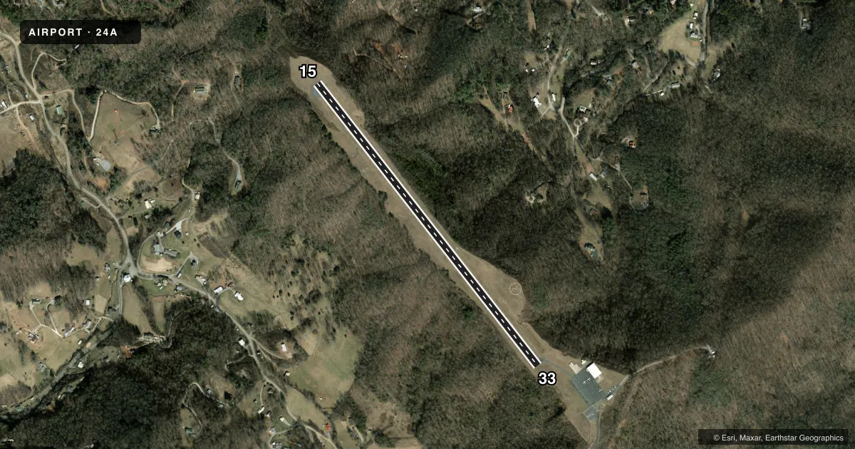
Airport sketch
Runways drawn to scale from FAA survey coordinates, rendered over satellite imagery. Not for navigation.
Approaches & charts
Services on the field
Fuel grades, oxygen, maintenance, ramp storage and lighting — as declared to the FAA by the airport operator.
Fuel & services
- Fuel
- 100LL
- Oxygen (bottled)
- Not available
- Oxygen (bulk)
- Not available
- Airframe repair
- Not available
- Power plant repair
- Not available
Ramp & ground
- Transient storage
- Tie-down
- Landing fee
- No fee published
- Customs
- Not available
- Lighting schedule
- SEE RMK
- Beacon schedule
- SS-SR
- Beacon
- White / Green (civil land)(WG)
- Wind indicator
- Lighted
- Segmented circle
- Yes
Fuel & FBOs
Cheapest 100LL and Jet A on the field and nearby. Always confirm with the FBO before taxi.
Airport notes
Surface conditions, obstructions, local procedures, lighting outages and other notes published with each FAA cycle.
General notes
- MTN HAZ RED BCN LGTS LCTD ON MTN RANGE APPROX 1.7 MILES SSW OF ARPT - LGTS OPN UNRELBL.
- RWY 15 300 FT DROP-OFF 300 FT FM THLD BOTH SIDES AND 90 FT LEFT/RIGHT OF CNTRLN ALONG RWY.
- RWY 33 300 FT DROP-OFF 200 FT FM THLD 50 FT LEFT OF CNTRLN.
- RPDLY RSG TRRN ALL QUADS.
- FOR CD CTC ATLANTA ARTCC AT 770-210-7692.
- COLD TEMPERATURE AIRPORT. ALTITUDE CORRECTION REQUIRED AT OR BELOW -13C.
- NO DSGND HELI AT THIS ARPT - ARPT MASTER RECORD INCORRECTLY DESIGNATES H1 EXISTS.
Lighting notes
- AFTER SS ACTVT REIL RWY 33; PAPI RWY 15 & 33; MIRL RWY 15/33 - CTAF.
Fuel notes
- 100LLFUEL 24 HOUR CREDIT CARD SVC AVBL.
Approach & departure obstructions
- 15NOTAM IN EFFECT - OTS INDEFLY.
- 15UNUSBL BYD 8 DEG LEFT OF CNTRLN.
- 33DSPLD THLD SLOPE 18:1 .
VFR map & nearby airports
VFR sectional. Tap any ICAO chip to open that airport.
Key facts · 24A
Answer card- ICAO
- 24A
- Name
- JACKSON COUNTY
- Location
- SYLVA, NORTH CAROLINA
- Elevation
- 2,857 ft MSL
- Traffic pattern altitude
- 3,857 ft MSL (1,000 AGL)
- Control tower
- Non-towered (use CTAF)
- Total runways
- 1
- Longest runway
- 15/33 · 3,210 ft
- Published ILS approaches
- 0
- Published frequencies
- 2
- Magnetic variation
- 5°
- Current flight rules
- LIFR
- Current wind
- 000° at 0 kt
- Favored runway now
- –
Jackson County Airport (24A) sits in Sylva, North Carolina. The field elevation is 2,857 ft MSL. It has one runway, 15/33, which is 3,210 ft long. There is no control tower. CTAF and UNICOM are both 123.0. No ILS approaches are published.
The published pattern altitude is not listed, so use the standard 1,000 ft AGL unless the current Chart Supplement says otherwise. Jackson County Airport is a mountain field with rapidly rising terrain in all quadrants. That matters here. Runway 33 has a 300-foot drop-off near the threshold area. Runway 15 also has steep drop-offs close in. Plan your arrival with extra margin, especially if you are new to mountain flying.
Jackson County Airport is the on-field FBO. It carries 100LL. 24-hour credit card self-serve fuel is available. After sunset, runway lighting and the PAPI are activated through the CTAF. There is a note that runway 15 lighting is out of service indefinitely. Cold temperature correction is required at or below minus 13 degrees Celsius. For IFR clearance delivery, contact Atlanta ARTCC. The airport also has mountain hazard beacons south-southwest of the field. They are reported as unreliable.