METAR & TAF KDZJ
Current METAR
Observed 13:35Z
KDZJ 271335Z AUTO 00000KT 7SM BR CLR 24/23 A3000 RMK AO2 LTG DSNT W AND NW P0001 T02430227
- Wind
- 000° @ 0 kt
- Visibility
- 7 SM
- Temp / Dew
- 24°C / 23°C
- Altimeter
- 30.00 inHg
- Clouds
- CLR
- Density alt
- 3,345 ft
- Ceiling
- Unlimited
- Rules
- VFR
Airport info & contacts
Manager on record, flight service, ARTCC, attendance schedule and pattern altitude — published by the FAA and refreshed every 28 days.
Location
- From city
- 3 NM SW
- VFR sectional
- ATLANTA
- ARTCC
- ZTL · ATLANTA
- NOTAM facility
- MCN (NOTAM-D)
Airport manager
- Name
- DAN FIREBAUGH
- Phone
- 706-745-4307
- Address
- 579 AIRPORT TERMINAL DRIVE, BLAIRSVILLE GA 30512
Flight service · Hours
- FSS MCN
- MACON1-800-WX-BRIEF
- Attendance
- 0800-1700
Frequencies
Tap any row to copy the frequency to your clipboard.
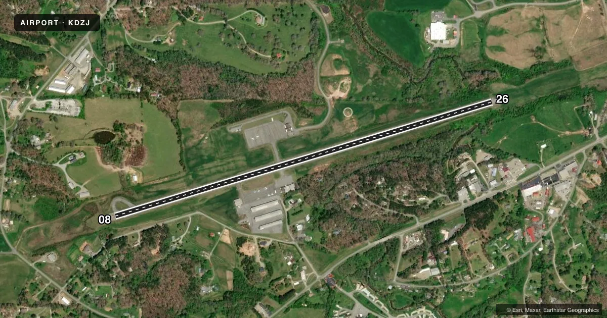
Runways & pattern
Full pagePattern entry · RWY 08
LEFT TRAFFICRunway end performance
| End | TORA | TODA | ASDA | LDA | VGSI | Approach lights | Obstruction |
|---|---|---|---|---|---|---|---|
| 08 | 5,004' | 5,004' | 5,004' | 4,017' | PAPI 2-box left(3.31°) | — | 67', trees, 507' from thr, 291' R of cntrln, slope 4 |
| 26 | 5,004' | 5,004' | 5,004' | 4,319' | PAPI 2-box left(3.54°) | — | 30', trees, 201' from thr, 155' R of cntrln, slope 0 |
Declared distances in feet. TORA = takeoff run available, TODA = takeoff distance, ASDA = accelerate-stop, LDA = landing distance.
Airport sketch
Runways drawn to scale from FAA survey coordinates, rendered over satellite imagery. Not for navigation.
Approaches & charts
Services on the field
Fuel grades, oxygen, maintenance, ramp storage and lighting — as declared to the FAA by the airport operator.
Fuel & services
- Fuel
- 100LLA+
- Oxygen (bottled)
- Not available
- Oxygen (bulk)
- Not available
- Airframe repair
- Not available
- Power plant repair
- Not available
- Other services
- AVNCS,INSTR,RNTL
Ramp & ground
- Transient storage
- Tie-down
- Landing fee
- No fee published
- Customs
- Not available
- Lighting schedule
- SEE RMK
- Beacon schedule
- SS-SR
- Beacon
- White / Green (civil land)(WG)
- Wind indicator
- Lighted
- Segmented circle
- Yes
Fuel & FBOs
Cheapest 100LL and Jet A on the field and nearby. Always confirm with the FBO before taxi.
Airport notes
Surface conditions, obstructions, local procedures, lighting outages and other notes published with each FAA cycle.
General notes
- WILDLIFE INCLG DEER AND GEESE, INVOF RWYS AND TWYS.
- FOR CD CTC ATLANTA ARTCC AT 770-210-7692.
Lighting notes
- ACTVT PAPI RWY 08 & 26; MIRL RWY 08/26 - CTAF.
Fuel notes
- 100LLLCTD ON NORTH SIDE OF RWY.
- A+AVBL DRG OPRG HOURS 0800 TO 1800.
Runway surface & condition
- 08/26RWY SLPS DOWNHILL 1.5 PCT EAST.
Approach & departure obstructions
- 26RWY 26 +10 FT-13 FT HILL 135 FT-250 FT L&R, 20 FT TREES 147 FT LEFT 0 FT-200 FT FM END OF RWY.
- 26UNUSBL BYD 1.3 NM DUE TO TRRN.
- 08APCH RATIO 15:1 TO DSPLCD THR; 177 FT TREES 2653 FT FM DSPLCD THR 451 FT LEFT.
VFR map & nearby airports
VFR sectional. Tap any ICAO chip to open that airport.
Key facts · KDZJ
Answer card- ICAO
- KDZJ
- Name
- BLAIRSVILLE
- Location
- BLAIRSVILLE, GEORGIA
- Elevation
- 1,906.9 ft MSL
- Traffic pattern altitude
- 2,906.9 ft MSL (1,000 AGL)
- Control tower
- Non-towered (use CTAF)
- Total runways
- 1
- Longest runway
- 08/26 · 5,004 ft
- Published ILS approaches
- 0
- Published frequencies
- 2
- Magnetic variation
- 3°
- Current flight rules
- VFR
- Current wind
- 000° at 0 kt
- Favored runway now
- –
Blairsville Airport sits in Blairsville, Georgia. The field elevation is 1,906.9 ft MSL. It has one runway. Runway 08/26 is 5,004 ft long with asphalt pavement. There is no control tower. CTAF and UNICOM are both 122.8. No ILS approaches are published here.
Pattern altitude is not published. Use the standard 1,000 ft AGL for light piston traffic unless the current Chart Supplement says otherwise. The on-field FBO is Blairsville Airport. It carries 100LL and Jet A. 100LL is on the north side of the runway. A+ fuel is available during operating hours from 0800 to 1800.
This is a mountain airport with terrain close in. Runway 26 is unusable beyond 1.3 NM because of terrain. Runway 26 also has trees and a small hill near the approach area. Runway 08 has a steep approach path with tall trees near the displaced threshold. The runway slopes downhill 1.5 percent to the east. Wildlife is also a factor here. Deer and geese are reported near the runways and taxiways. PAPI and medium intensity runway lights on 08 and 26 are activated by CTAF. For IFR clearance delivery, contact Atlanta ARTCC. Check the current Chart Supplement before you go.