METAR & TAF KRVN
KRVN does not publish a METAR.
Showing the nearest reporting station: KGCY (GREENEVILLE MUNI) · 16.1 NM away. Conditions at KRVN may differ.
METAR · KGCY
Observed 03:55Z
KGCY 270355Z AUTO 00000KT 10SM 23/22 A2998 RMK A01
- Wind
- 000° @ 0 kt
- Visibility
- 10 SM
- Temp / Dew
- 23°C / 22°C
- Altimeter
- 29.98 inHg
- Clouds
- Clear
- Density alt
- 2,441 ft
- Ceiling
- Unlimited
- Rules
- VFR
Airport info & contacts
Manager on record, flight service, ARTCC, attendance schedule and pattern altitude — published by the FAA and refreshed every 28 days.
Location
- From city
- 6 NM NE
- VFR sectional
- CINCINNATI
- ARTCC
- ZTL · ATLANTA
- NOTAM facility
- BNA (NOTAM-D)
Airport manager
- Name
- MARK FINLEY
- Phone
- 423-345-0219
- Address
- 675 MAIN ST, SURGOINSVILLE TN 37873
Flight service · Hours
- FSS BNA
- NASHVILLE1-800-WX-BRIEF
- Attendance
- 0800-1700
Frequencies
Tap any row to copy the frequency to your clipboard.
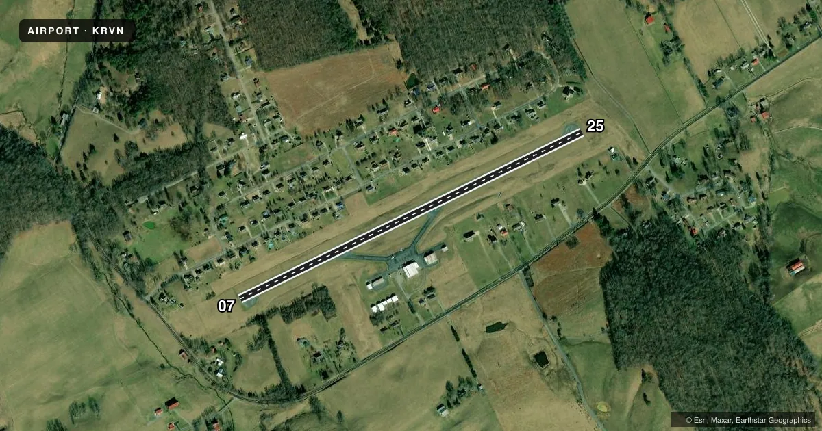
Runways & pattern
Full pagePattern entry · RWY 07
LEFT TRAFFICRunway end performance
| End | TORA | TODA | ASDA | LDA | VGSI | Approach lights | Obstruction |
|---|---|---|---|---|---|---|---|
| 07 | — | — | — | — | PAPI 2-box left(4°) | — | 24', trees, 637' from thr, 144' R of cntrln, slope 18 |
| 25 | — | — | — | — | PAPI 2-box left(3°) | — | 72', trees, 1025' from thr, 225' R of cntrln, slope 11 |
Declared distances in feet. TORA = takeoff run available, TODA = takeoff distance, ASDA = accelerate-stop, LDA = landing distance.
Airport sketch
Runways drawn to scale from FAA survey coordinates, rendered over satellite imagery. Not for navigation.
Approaches & charts
Services on the field
Fuel grades, oxygen, maintenance, ramp storage and lighting — as declared to the FAA by the airport operator.
Fuel & services
- Fuel
- 100LL
- Airframe repair
- Major
- Power plant repair
- Major
- Other services
- INSTR
Ramp & ground
- Transient storage
- Tie-down
- Hangar
- Landing fee
- No fee published
- Customs
- Not available
- Lighting schedule
- SEE RMK
- Beacon schedule
- SS-SR
- Beacon
- White / Green (civil land)(WG)
- Wind indicator
- Lighted
- Segmented circle
- Yes
Fuel & FBOs
Cheapest 100LL and Jet A on the field and nearby. Always confirm with the FBO before taxi.
Airport notes
Surface conditions, obstructions, local procedures, lighting outages and other notes published with each FAA cycle.
General notes
- DEER ON & INVOF ARPT.
- FOR CD CTC ATLANTA ARTCC AT 770-210-7692.
Lighting notes
- ACTVT RWY 7 & 25 REILS; PAPIS 7 & 25; MIRLS RWY 7/25 - CTAF.
Fuel notes
- 100LLH24 SELF SVC FUEL AVBL.
Approach & departure obstructions
- 073118 FT MT RIDGE SE OF ARPT WI 9 NM.
- 07PAPI UNUSBL BYD 7 DEGS LEFT OF CNTRLN.
Other notes
- 1UNATNDD MAJOR HOL.
VFR map & nearby airports
VFR sectional. Tap any ICAO chip to open that airport.
Key facts · KRVN
Answer card- ICAO
- KRVN
- Name
- HAWKINS COUNTY
- Location
- ROGERSVILLE, TENNESSEE
- Elevation
- 1,254.6 ft MSL
- Traffic pattern altitude
- 2,254.6 ft MSL (1,000 AGL)
- Control tower
- Non-towered (use CTAF)
- Total runways
- 1
- Longest runway
- 07/25 · 3,504 ft
- Published ILS approaches
- 0
- Published frequencies
- 4
- Magnetic variation
- 7°
- Current flight rules
- VFR
- Current wind
- 000° at 0 kt
- Favored runway now
- –
Hawkins County Airport sits in Rogersville, Tennessee. The field elevation is 1,254.6 ft MSL. It has one runway, 07/25, which is 3,504 ft long. There is no control tower. CTAF and UNICOM are both 122.8. Approach and departure service is handled by TRI CITY on 128.05 and 317.5.
No ILS approaches are published here. The pattern altitude is not published, so use the standard 1,000 ft AGL for light piston operations unless the current Chart Supplement says otherwise. Runway 07 has medium intensity lighting. Runway end identifier lights are installed on 07 and 25. Precision approach path indicators are also installed on both ends. The published remarks say the PAPI on runway 07 is unusable beyond 7 degrees left of centerline. That matters on short final.
Hawkins County Airport has Hawkins County Airport on the field. It carries 100LL. 24-hour self-serve 100LL is available. The airport is unattended on major holidays. Deer are reported on and near the airport. There is also a 3,118-foot mountain ridge southeast of the airport within 9 NM of runway 07, so pay attention to terrain and climb performance when departing that direction.