METAR & TAF KBLF
Current METAR
Observed 07:59Z
KBLF 270759Z AUTO 00000KT 8SM SCT005 BKN021 OVC041 19/18 A3000 RMK AO2 T01890183
- Wind
- 000° @ 0 kt
- Visibility
- 8 SM
- Temp / Dew
- 19°C / 18°C
- Altimeter
- 30.00 inHg
- Clouds
- OVC
- Density alt
- 3,923 ft
- Ceiling
- 2,100 ft AGL
- Rules
- MVFR
Airport info & contacts
Manager on record, flight service, ARTCC, attendance schedule and pattern altitude — published by the FAA and refreshed every 28 days.
Location
- From city
- 3 NM NE
- VFR sectional
- CINCINNATI
- ARTCC
- ZID · INDIANAPOLIS
- NOTAM facility
- BLF (NOTAM-D)
Airport manager
- Name
- JIM PILKINS
- Phone
- 304-327-5308
- Address
- 300 MARKELL DR. STE 201, BLUEFIELD WV 24701
Flight service · Hours
- FSS EKN
- ELKINS703-724-42881-800-WX-BRIEF
- Attendance
- 0600-2100
Frequencies
Tap any row to copy the frequency to your clipboard.
Runways & pattern
Full pagePattern entry · RWY 05
LEFT TRAFFICRunway end performance
| End | TORA | TODA | ASDA | LDA | VGSI | Approach lights | Obstruction |
|---|---|---|---|---|---|---|---|
| 05 | 4,743' | 4,743' | 4,743' | 4,743' | PAPI 4-box left(3°) | — | 35', trees, 201' from thr, 330' R of cntrln, slope 0 |
| 23 | 4,743' | 4,743' | 4,743' | 4,743' | PAPI 4-box left(3°) | — | 40', trees, 201' from thr, 300' R of cntrln, slope 0 |
Declared distances in feet. TORA = takeoff run available, TODA = takeoff distance, ASDA = accelerate-stop, LDA = landing distance.
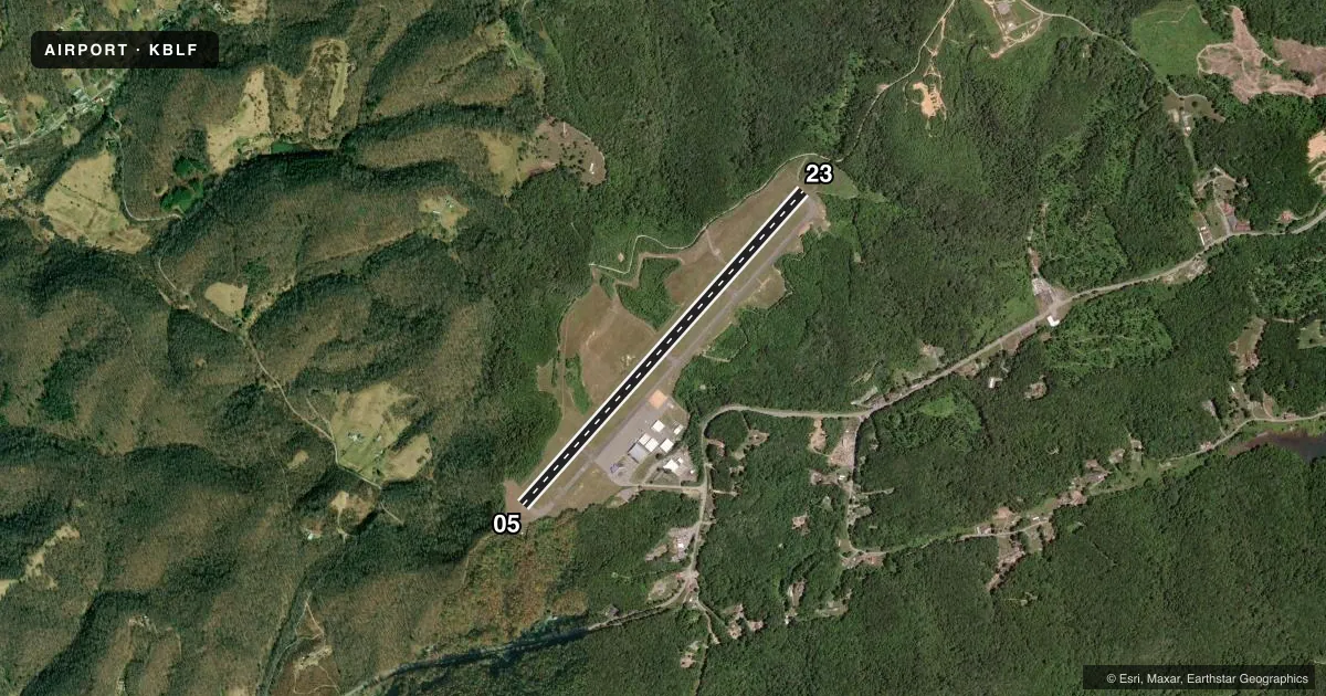
Airport sketch
Runways drawn to scale from FAA survey coordinates, rendered over satellite imagery. Not for navigation.
Approaches & charts
ILS · 1
Services on the field
Fuel grades, oxygen, maintenance, ramp storage and lighting — as declared to the FAA by the airport operator.
Fuel & services
- Fuel
- 100LLAA+
- Oxygen (bottled)
- Not available
- Oxygen (bulk)
- Not available
- Airframe repair
- Major
- Power plant repair
- Major
- Other services
- INSTR
Ramp & ground
- Transient storage
- Tie-down
- Hangar
- Landing fee
- No fee published
- Customs
- Not available
- Lighting schedule
- SEE RMK
- Beacon schedule
- SS-SR
- Beacon
- White / Green (civil land)(WG)
- Wind indicator
- Lighted
Fuel & FBOs
Cheapest 100LL and Jet A on the field and nearby. Always confirm with the FBO before taxi.
Airport notes
Surface conditions, obstructions, local procedures, lighting outages and other notes published with each FAA cycle.
General notes
- MOWING IN PROGRESS APR-NOV ALL SFCS.
- DEER & BIRDS ON & INVOF ARPT.
- RWY 23 HAS STEEP DROP-OFF 320 FT FM THR 0B, 280 FT L AND R.
- RWY 05 HAS STEEP DROP-OFF 175 FT FM THR L SIDE.
- FOR CD IF UNA TO CTC ON FSS FREQ, CTC INDIANAPOLIS ARTCC AT 317-247-2411.
Lighting notes
- ACTVT REIL RWY 05 & 23; PAPI RWY 05 & 23; HIRL RWY 05/23; TWY LIGHTS - CTAF.
Fuel notes
- 100LL24 HR SELF-SERVE FUEL. FUEL ALSO AVBL BY TRUCK DRG ATND HRS OR AFTR HRS BY PRIOR ARGMNT, $75 CALL-OUT FEE. LINE OFC PH 304-327-8440.
Approach & departure obstructions
- 0535 FT TREES, UP TO 199 FT DSTC, 300 FT RIGHT.
- 2340 FT TREES, 0 FT DSTC, 300 FT R.
Other notes
- ROTARY WING REPAIRS ONLY. FIXED WING RPRS AVBL ON CALL, CTC AMGR.
- ROTARY WING REPAIRS ONLY. FIXED WING RPRS AVBL ON CALL, CTC AMGR.
- 1ARPT UNATND CHRISTMAS & NEW YEARS. FOR SVCS CALL 304-921-3417 (LINE STAFF CELL).
- MANAGERMGR CELL 304-921-3417.
VFR map & nearby airports
VFR sectional. Tap any ICAO chip to open that airport.
Key facts · KBLF
Answer card- ICAO
- KBLF
- Name
- MERCER COUNTY
- Location
- BLUEFIELD, WEST VIRGINIA
- Elevation
- 2,856.8 ft MSL
- Traffic pattern altitude
- 3,856.8 ft MSL (1,000 AGL)
- Control tower
- Non-towered (use CTAF)
- Total runways
- 1
- Longest runway
- 05/23 · 4,743 ft
- Published ILS approaches
- 1
- Published frequencies
- 1
- Magnetic variation
- 7°
- Current flight rules
- MVFR
- Current wind
- 000° at 0 kt
- Favored runway now
- –
Mercer County Airport (KBLF) sits in Bluefield, West Virginia. Field elevation is 2,856.8 ft MSL. The airport has one runway. Runway 05/23 is 4,743 ft long with asphalt pavement. There is no control tower, so use CTAF 122.9 for traffic calls and taxiway lighting control. The published pattern altitude is not listed. Use the standard 1,000 ft AGL pattern unless the current Chart Supplement says otherwise.
This field has one ILS approach to runway 23. That matters here because the airport sits high enough that performance planning should be part of the preflight. The published remarks also note steep drop-offs near both runway ends. Runway 05 has trees off the right side near the departure end. Runway 23 has trees right at the end. Deer and birds are also reported on and near the airport, so keep a sharp scan on short final and in the pattern.
Mercer County Airport Authority is on the field. It carries 100LL, Jet A and Jet A Prist. Twenty-four hour self-serve 100LL is available. Truck fuel is also available during attended hours or by prior arrangement. The airport manager is the contact for fixed-wing repair requests. Mowing runs from April through November on all surfaces.