METAR & TAF KHLX
Current METAR
Observed 09:35Z
KHLX 270935Z AUTO 36003KT 10SM CLR 20/18 A2997 RMK AO2
- Wind
- 360° @ 3 kt
- Visibility
- 10 SM
- Temp / Dew
- 20°C / 18°C
- Altimeter
- 29.97 inHg
- Clouds
- CLR
- Density alt
- 3,878 ft
- Ceiling
- Unlimited
- Rules
- VFR
Airport info & contacts
Manager on record, flight service, ARTCC, attendance schedule and pattern altitude — published by the FAA and refreshed every 28 days.
Location
- From city
- 7 NM NE
- VFR sectional
- CINCINNATI
- ARTCC
- ZDC · WASHINGTON
- NOTAM facility
- HLX (NOTAM-D)
Airport manager
- Name
- MICHAEL LAWSON
- Phone
- 276-728-4504
- Address
- 504 HANGAR RD., HILLSVILLE VA 24343-5264
Flight service · Hours
- FSS DCA
- LEESBURG1-800-WX-BRIEF
- Attendance
- M-F · 0800-1700
Frequencies
Tap any row to copy the frequency to your clipboard.
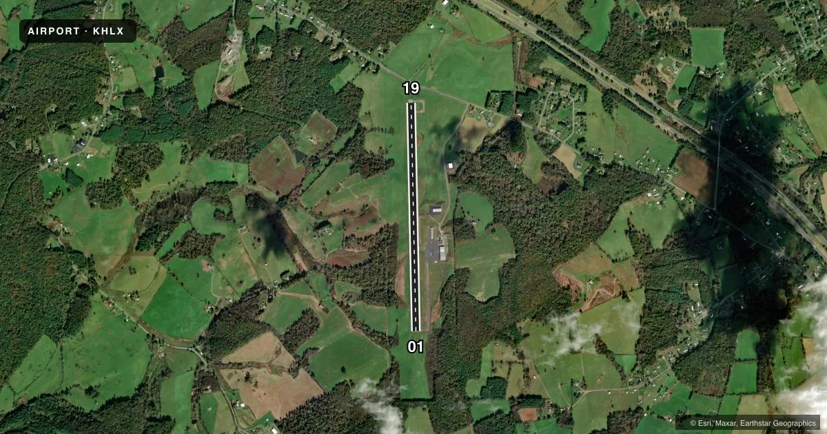
Runways & pattern
Full pagePattern entry · RWY 01
LEFT TRAFFICRunway end performance
| End | TORA | TODA | ASDA | LDA | VGSI | Approach lights | Obstruction |
|---|---|---|---|---|---|---|---|
| 01 | — | — | — | — | PAPI 2-box left(3°) | — | 41', trees, 985' from thr, 355' R of cntrln, slope 19 |
| 19 | — | — | — | — | PAPI 2-box left(3°) | — | 54', trees, 1237' from thr, 63' R of cntrln, slope 19 |
Declared distances in feet. TORA = takeoff run available, TODA = takeoff distance, ASDA = accelerate-stop, LDA = landing distance.
Airport sketch
Runways drawn to scale from FAA survey coordinates, rendered over satellite imagery. Not for navigation.
Approaches & charts
Services on the field
Fuel grades, oxygen, maintenance, ramp storage and lighting — as declared to the FAA by the airport operator.
Fuel & services
- Fuel
- 100LLA+
- Oxygen (bottled)
- Not available
- Oxygen (bulk)
- Not available
- Airframe repair
- Major
- Power plant repair
- Major
- Other services
- INSTR,RNTL
Ramp & ground
- Transient storage
- Tie-down
- Landing fee
- No fee published
- Customs
- Not available
- Lighting schedule
- SEE RMK
- Beacon schedule
- SS-SR
- Beacon
- White / Green (civil land)(WG)
- Wind indicator
- Lighted
- Segmented circle
- No
Fuel & FBOs
Cheapest 100LL and Jet A on the field and nearby. Always confirm with the FBO before taxi.
Airport notes
Surface conditions, obstructions, local procedures, lighting outages and other notes published with each FAA cycle.
General notes
- DEER ON & INVOF ARPT.
- RWY 01 10-20 FT HILL LCTD 150 FT W OF RWY 01 BEGINNING N OF THLD.
- ROA TWR SVCS AVBL AT 540-563-1307.
- FOR CD CTC ROANOKE APCH AT 540-563-1307.
Lighting notes
- ACTVT MIRL RWY 1/19 - CTAF. REILS RWY 1 & 19; PAPI RWY 1 & 19 OPS CONSLY.
Fuel notes
- 100LLSELF-SVC FUEL AVLB 24 HRS WITH CREDIT CARD.
Approach & departure obstructions
- 19RWY MRKG CONDS VARY BTWN GOOD & FAIR. RWY DISPLACEMENT MRKG INCORRECT.
- 01RWY 01 HAS 10-20 FT HILL LCTD 150 FT W OF RWY 01, BEGINNING N OF THLD.
Other notes
- 1WKEND ATTENDANCE: COORDINATE DRG RGLR WEEKLY BUS HRS.
- 1AFT HRS TRML ACCESS AVBL S SIDE OF BLDG.
- 1UNATNDD NEW YEAR'S DAY, EASTER, THANKSGIVING, & CHRISTMAS.
- OWNERFAX 276-728-4544.
VFR map & nearby airports
VFR sectional. Tap any ICAO chip to open that airport.
Key facts · KHLX
Answer card- ICAO
- KHLX
- Name
- TWIN COUNTY
- Location
- GALAX HILLSVILLE, VIRGINIA
- Elevation
- 2,693.7 ft MSL
- Traffic pattern altitude
- 3,693.7 ft MSL (1,000 AGL)
- Control tower
- Non-towered (use CTAF)
- Total runways
- 1
- Longest runway
- 01/19 · 4,151 ft
- Published ILS approaches
- 0
- Published frequencies
- 4
- Magnetic variation
- 8°
- Current flight rules
- VFR
- Current wind
- 360° at 3 kt
- Favored runway now
- RWY 01
Twin County Airport sits near Galax Hillsville, Virginia. Field elevation is 2,693.7 ft MSL. The airport has one runway, 01/19, at 4,151 ft. There is no control tower. Pattern altitude is not published, so use the standard 1,000 ft AGL for light piston operations unless the current FAA Chart Supplement says otherwise.
No ILS approaches are published here. CTAF and UNICOM are both 122.8. Roanoke Approach handles the approach and departure side on 126.0 and 339.8. The on-field FBO is Twin County Airport. It carries 100LL and JET A Prist. Self-serve 100LL is available 24 hours with credit card. The field is unattended on New Year’s Day, Easter, Thanksgiving and Christmas. Weekend attendance is coordinated during regular weekly business hours.
A few operational items matter here. Runway 01 has a 10 to 20 ft hill about 150 ft west of the runway beginning north of the threshold. Deer are reported on and near the airport. Runway lighting is medium intensity and is activated by CTAF. REILs are on both ends. The PAPI on runway 01 and runway 19 operates continuously. Runway marking conditions vary between good and fair. The runway displacement marking is incorrect. For a first visit, brief the elevation. Watch the terrain near runway 01. Verify current procedures with the airport operator or the current FAA Chart Supplement before you go.